Three-dimensional space firefighting command controlling system

A three-dimensional and spatial technology, applied in transmission systems, TV system components, image data processing, etc., can solve problems such as insufficient understanding, errors, and insufficiencies, and achieve active rescue of companions, accurate fire locations, and scientific paths Effect

Active Publication Date: 2017-01-11
宁波琦美文旅科技有限公司
View PDF4 Cites 9 Cited by
  • Summary
  • Abstract
  • Description
  • Claims
  • Application Information

AI Technical Summary

Problems solved by technology

[0005] Therefore, after knowing the location of the firefighting facilities, the firefighters enter the fire scene, the determination, understanding, and understanding of the firefighting target are not comprehensive enough, and there are large e

Method used


Image

  • Three-dimensional space firefighting command controlling system
  • Three-dimensional space firefighting command controlling system
  • Three-dimensional space firefighting command controlling system

Examples


Embodiment Construction

[0040] The present invention will be described in further detail below in conjunction with the accompanying drawings.

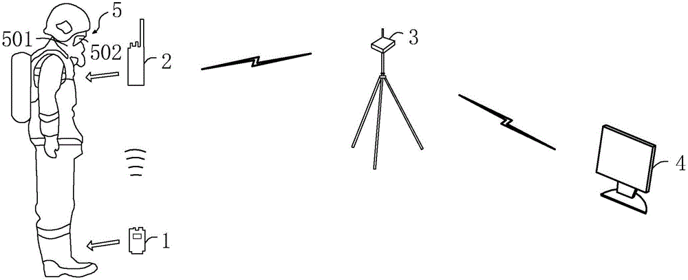
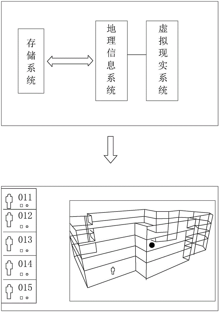
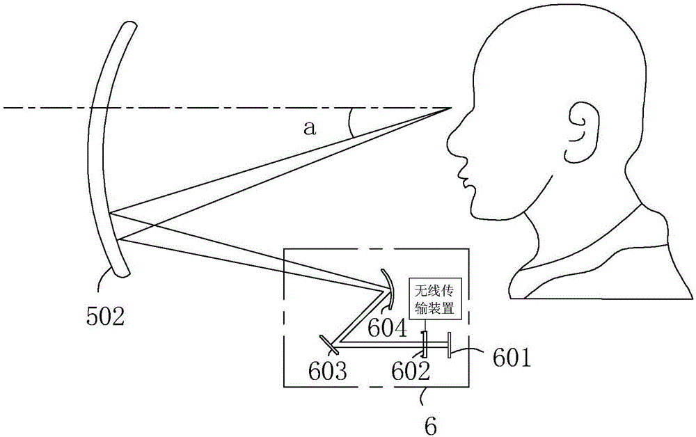
[0041] Such as figure 1 As shown, a three-dimensional space fire command and control system includes a locator 1, a firefighter data terminal 2, a backfield data terminal 3, a backfield host 4, an air mask 5, and a projection device 6;

[0042] The locator 1 has a GPS module and a heart rate detection module. The locator 1 is worn on the firefighter (mainly on the ankle of the firefighter). The GPS module in the locator 1 is used to locate the location information of the firefighter, and the heart rate The detection module is used to monitor the vital signs information of the firefighters. The vital signs information is mainly the beating of the pulse. The locator 1 transmits the location information and vital signs information to the firefighter data terminal 2 via wireless after the firefighters enter the fire scene;

[0043] The firefighter data terminal ...


PUM


Abstract

The invention discloses a three-dimensional space firefighting command controlling system. The system is characterized in that a positioner and a firefighter data terminal are worn by a firefighter, a backfield data terminal and a backfield host connected with the backfield data terminal in a wireless manner are arranged at an on-site command position, the positioner calculates a positioning result of the firefighter, transmits the result to the firefighter data terminal, and sends data to the backfield data terminal through the firefighter data terminal, and the backfield host receives the data from the backfield data terminal and displays real-time position and track of the firefighter. According to the system, a holographic three-dimensional space model is constructed by employing the GIS technology, the VR technology is employed, two-group, two-dimensional and real-scene three-dimensional seamless integration in a fire scene range can be realized, the positioning of positions and movement tracks of the firefighters in the fire scene space can be realized by employing a VR+ data terminal, the entire time-space and multi-dimensional system with high space precision is constructed, and the safety of the firefighters is guaranteed in an omnibearing manner.

Description

technical field [0001] The invention relates to the field of command and control technology, in particular to a three-dimensional space fire command and control system. Background technique [0002] GIS is a geographic information system, which uses traditional cartography methods to express geographic information through abstract symbols such as various thematic maps and symbol libraries, and provides a macroscopic abstract expression method for geographic information, which greatly simplifies people's understanding of maps. However, the two-dimensional geographic information system provides users with only two-dimensional plane graphics, and there is no substantial improvement in the degree of visualization compared with traditional paper maps. With the deepening of GIS applications, This is far from satisfying people's visual needs; therefore, the conceptual model of two-dimensional visualization that simplifies the real world into a two-dimensional projection on a plane ...

Claims


Application Information

Patent Timeline
IPC IPC(8): G06T19/00G06T17/05G06F17/30G06Q10/04G06Q50/26H04N5/225H04W4/02H04B1/38A62C37/00
CPCA62C37/00H04B1/385H04W4/025G06F16/29G06Q10/047G06Q50/265G06T17/05G06T19/003H04N23/50
Inventor 蒋海富
Owner 宁波琦美文旅科技有限公司
Why Eureka
Try Eureka