A method for automatic processing of railway thematic map elements in remote sensing images

A remote sensing image and automatic processing technology, applied in electrical digital data processing, special data processing applications, maps/plans/charts, etc., can solve the problems of large editing work, inability to draw in batches, unfavorable drawing efficiency, etc., and achieve the editing workload. Reduce and improve the effect of drawing efficiency and drawing quality

Active Publication Date: 2018-11-27
CHINA RAILWAY DESIGN GRP CO LTD
View PDF4 Cites 0 Cited by
  • Summary
  • Abstract
  • Description
  • Claims
  • Application Information

AI Technical Summary

Problems solved by technology

Since most map drawing platforms cannot provide automatic drawing of the above thematic elements, and thematic information does not appear in the map according to certain rules, batch drawing is not possible
Therefore, the current technical means are mainly manual drawing. In order to improve the efficiency in the drawing process, the method of calling the legend library is often used. However, the shape, angle, and color of the icon symbols called by this method are all fixed values, and the post-editing work is huge. Conducive to the improvement of drawing efficiency

Method used


Image

  • A method for automatic processing of railway thematic map elements in remote sensing images

Examples


Embodiment Construction

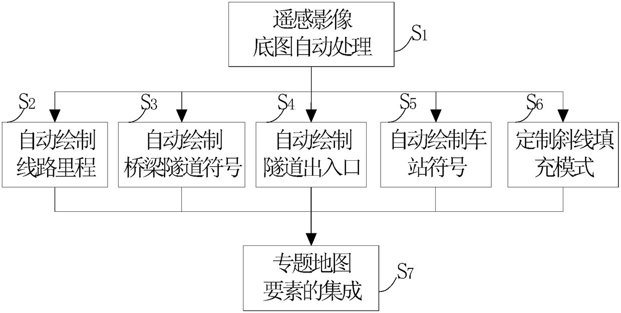
[0030] The present invention relates to a method for automatically processing elements of a remote sensing image railway thematic map, the technical steps comprising: automatic processing of remote sensing image base maps (S1), automatic drawing of line mileage (S2), automatic drawing of bridge and tunnel symbols (S3), automatic drawing Tunnel entrances and exits (S4), automatic drawing of station symbols (S5), customized slash fill mode (S6), integration of thematic map elements (S7). .

[0031] S 1 , Remote sensing image base map automatic processing

[0032] According to the characteristics of remote sensing images, the specified batch processing template is selected in the ground feature database of remote sensing images to automatically process the color difference and color cast in batches of remote sensing images. For example, a QuickBird multispectral data with a resolution of 0.61 meters was shot under poor weather conditions, the color was bluish and the image brig...


PUM


Abstract

The invention discloses an automatic processing method for essential factors of a remote-sensing image railway thematic map. The method comprises technical steps that a base map of a remote sensing image is processed automatically, and aberration and color cast of batch of remote sensing image data are processed automatically; a route mileage is drafted automatically, and mileage marks and characters are drafted automatically by being perpendicular to a path; bridge and tunnel symbols are drafted automatically according to a foreground color; entrances and exits of the tunnels are drafted automatically; a station symbol is drafted automatically, and the length of a station mark and orientations of platforms are determined according to positions specified by a user; an inclined line filling mode is customized according to specific modes and angles; and the essential factors of the thematic map are integrated by adjusting the data topological relation of the essential factors of the thematic maps according to a map integration principle and integrating the data according to a file management mode.

Description

technical field [0001] The invention relates to a thematic mapping technology, in particular to a method for automatic processing of remote sensing image data and automatic drawing of elements in a map. Background technique [0002] As China's railway construction continues to heat up, thematic maps are more and more widely used in the entire life cycle of railway engineering construction. The generalized railway thematic elements in the remote sensing image railway thematic map include: remote sensing image base map, railway line orientation, mileage, stations, bridges, tunnels and controlling factors affecting the line orientation. [0003] The specific forms of these thematic elements in the map are base map, point, line, area, text, etc. Since most map-making platforms cannot provide automatic drawing of the above thematic elements, and thematic information does not appear in the map according to a certain rule, it cannot be drawn in batches. Therefore, the current tec...

Claims


Application Information

Patent Timeline
Patent Type & Authority Patents(China)
IPC IPC(8): G06F17/00
CPCG09B29/008
Inventor 杜辉黄守鑫王长进张朋明
Owner CHINA RAILWAY DESIGN GRP CO LTD
Why Eureka
Try Eureka