Satellite image positioning method and device

A satellite image and positioning method technology, applied in the field of satellite applications, can solve the problems that the precise positioning of satellite remote sensing images depends on ground control points and the difficulty of obtaining a sufficient number of ground control points.

Active Publication Date: 2017-03-15
SPACE STAR TECH CO LTD
View PDF3 Cites 9 Cited by
  • Summary
  • Abstract
  • Description
  • Claims
  • Application Information

AI Technical Summary

Problems solved by technology

[0003] In view of this, the present invention provides a satellite image positioning method and device applied to a charge-coupled device image sensor to solve the problem that the precise positioning of satellite remote sensing images in the prior art has always relied on ground control points, but obtaining a sufficient number of Ground control points are usually very difficult problems, and the technical solutions are as follows:

Method used


Image

  • Satellite image positioning method and device
  • Satellite image positioning method and device
  • Satellite image positioning method and device

Examples


Embodiment Construction

[0040] For reference and clarity, descriptions, abbreviations or abbreviations of technical terms used in the following text are summarized as follows:

[0041] WGS84: World Geodetic System 1984, a coordinate system established for the GPS global positioning system;

[0042] CCD sensor: Charge Coupled Device, charge coupled device image sensor;

[0043] RPC: Remote Procedure Call Protocol, Remote Procedure Call Protocol.

[0044] The following will clearly and completely describe the technical solutions in the embodiments of the present invention with reference to the accompanying drawings in the embodiments of the present invention. Obviously, the described embodiments are only some, not all, embodiments of the present invention. Based on the embodiments of the present invention, all other embodiments obtained by persons of ordinary skill in the art without making creative efforts belong to the protection scope of the present invention.

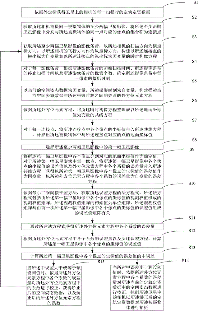
[0045] see figure 1 , is a schematic...


PUM


Abstract

The embodiment of the invention provides a satellite image positioning method and device applied to a charge-coupled device image sensor. By adoption of the method and device provided by the embodiment of the invention, under the condition of no ground control point, orbit determination and attitude determination data and coordinate value data of connection points of satellite images shot by a camera of a satellite under the orbit determination and attitude determination data can be obtained only according to external calibration, and spatial attitude data in the orbit determination and attitude determination data of the satellite are corrected. Specifically, the orbit determination and attitude determination data and a corresponding relation between the connection point coordinates and ground coordinate values corresponding to the connection points are utilized, an exterior orientation element equation of the spatial attitude data changing with time is built through a quadratic polynomial, and based on a collinearity equation, the ground coordinate values of the connection points are obtained and the least square method is utilized to perform iteration to solve the spatial attitude data.

Description

technical field [0001] The invention relates to the technical field of satellite applications, in particular to a satellite image positioning method and device. Background technique [0002] At present, the precise positioning of satellite remote sensing images has always relied on ground control points. However, it is usually very difficult to obtain a sufficient number of ground control points. Therefore, it is an urgent task to study the high-precision geometric processing of satellite remote sensing images without ground control points. Task. Contents of the invention [0003] In view of this, the present invention provides a satellite image positioning method and device applied to a charge-coupled device image sensor to solve the problem that the precise positioning of satellite remote sensing images in the prior art has always relied on ground control points, but obtaining a sufficient number of Ground control points are usually very difficult problems, and the tech...

Claims


Application Information

Patent Timeline
Patent Type & Authority Applications(China)
IPC IPC(8): G06T7/70
Inventor 陈刚靳笑琳王一赵颖芝折晓宇
Owner SPACE STAR TECH CO LTD
Why Eureka
Try Eureka