
Method for quantitatively recovering lake basin ancient water depth

A technology of water depth and lake basin, which is applied in the direction of measuring devices, nuclear radiation exploration, geophysical measurement, etc., and can solve the problems of low accuracy, high cost, and low accuracy

Inactive Publication Date: 2017-03-22
EXPLORATION & DEV RES INST OFSINOPEC JIANGHAN OILFIELD
View PDF5 Cites 9 Cited by
  • Summary
  • Abstract
  • Description
  • Claims
  • Application Information

AI Technical Summary

Problems solved by technology

[0010] (2) Geochemical marker method: The Th / U ratio curve can be approximately regarded as the relative change curve of paleo-depth, which can reflect the cycle of relative change of paleo-depth, but the accuracy is not high, and it can only reflect a rough range. Perform natural gamma ray spectroscopy logging
[0012] (4) Qualitative relative paleobathy curve method: the accuracy is very low, it can only represent the approximate range, and there are large errors and subjective judgment factors
[0013] (5) Quantitative paleowater depth restoration method: logging results of specified elements are required, which is costly and not universal

Method used


Image

  • Method for quantitatively recovering lake basin ancient water depth
  • Method for quantitatively recovering lake basin ancient water depth
  • Method for quantitatively recovering lake basin ancient water depth

Examples


Embodiment 1

[0077] Using the above method, a total of 35 wells were selected in the Xingouzui Formation in the Jiangling Sag of the Jianghan Basin to calculate the paleo-depth values ​​of this period, and finally the column diagram of the paleo-depth change of a single well and the contour map of the paleo-depth of the whole well were drawn , and successfully restored the paleowater depth distribution of the study interval in the study area (see attached Figure 5 ).

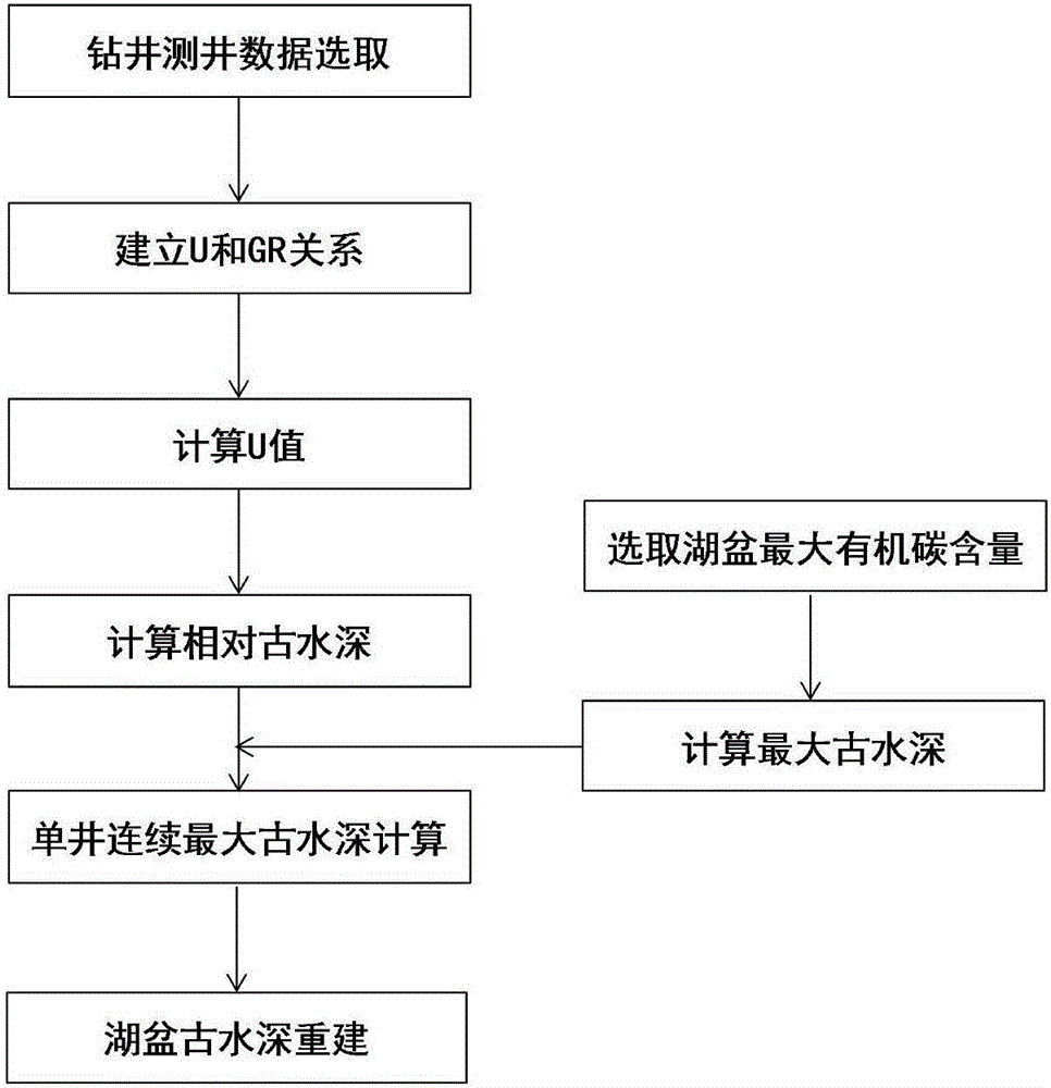
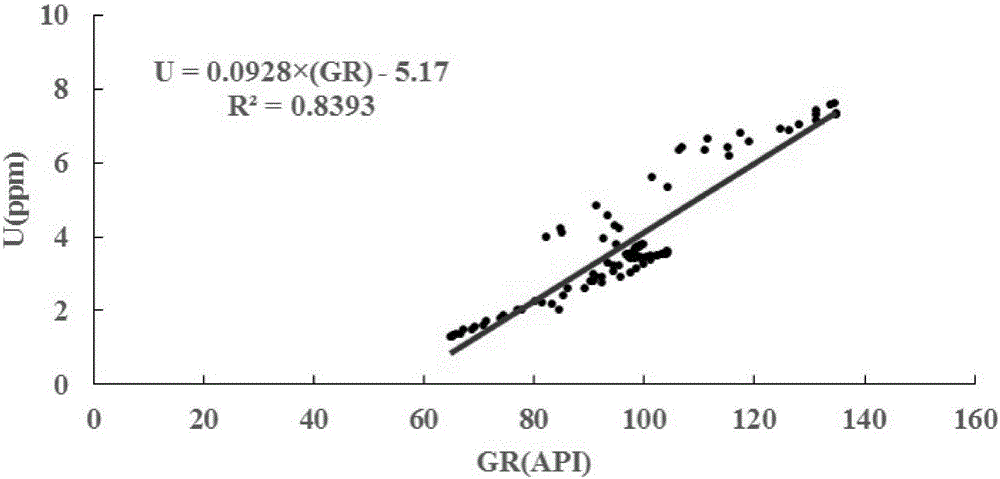
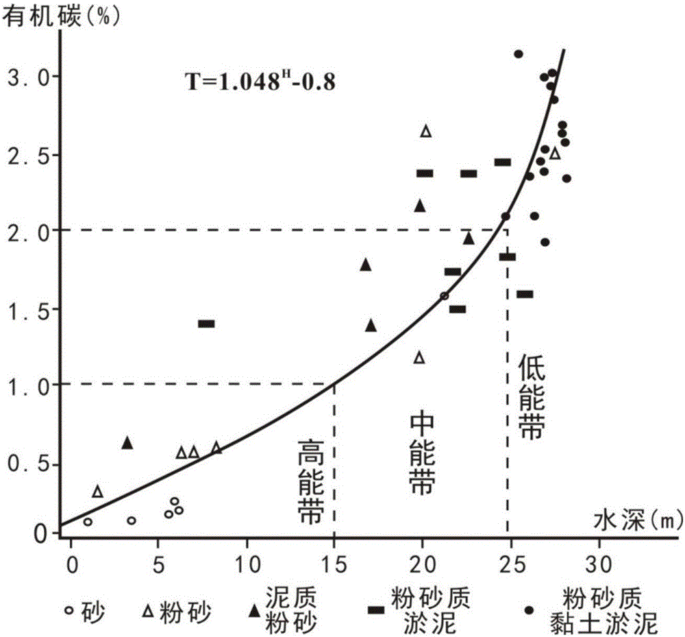
[0078] Take Well Wan 12 and oil group II in the study area as examples for illustration. According to the uranium and gamma values ​​in the mudstone section of Well Lu 13, the relationship between U value and GR value was established (see attached figure 2 ). The uranium value can be calculated according to the gamma value read in the mudstone section of Well Wan 12. The relative paleo-depth can be calculated by the uranium value (see attached image 3 ). The maximum value of organic carbon in the depositional period ...


PUM


Abstract

The invention discloses a method for quantitatively recovering a lake basin ancient water depth. The method comprises steps that gamma logging and natural gamma ray spectral logging of a randomly-selected well of a to-be-recovered lake basin are carried out; GR values and U values of a pure mudstone interval of a target interval are read; a function relationship of the GR values and the U values is established; a gamma value of a pure mudstone interval of a target interval of each other drilling well is measured, and U values are acquired through calculation; an actual water depth H can be acquired according to a formula H=Hmax*L / Lmax; calculation for each well is carried out, statistics of an actual average water depth value of the target interval of the wells is carried out, a lake basin ancient water depth distribution diagram of the target interval can be made, and lake basin ancient water depth reconstruction is carried out. The method is advantaged in that relative ancient water depth of each interval can be recovered through utilizing natural gamma logging curves (GR curves) of the drilling wells and a natural gamma ray spectral logging curve of a certain drilling well, in combination with deposition rules and actual quantitative calculation, the actual water depth is calculated, and a lake basin ancient water depth plane distribution diagram can be made.

Description

technical field [0001] The invention relates to the field of paleoenvironment restoration, in particular to a method for quantitatively restoring paleowater depths in lake basins. Background technique [0002] Paleo-depth restoration is an important part of paleoenvironmental research and basin analysis, as well as the key content of determining ancient sea level changes and paleogeomorphological restoration. The restoration of the water depth of ancient lacustrine basins is of great significance for studying the sedimentary history of ancient sedimentary basins, determining the types of sedimentary systems, and evaluating the conditions of oil and gas generation, storage, and caprock. At present, there are mainly the following methods for restoring the ancient water depth of lake basins: [0003] (1) Sedimentological method: Qualitative determination based on various sedimentological signs such as sediment distribution law, sedimentary structure, paleontological type, pale...

Claims


Application Information

Patent Timeline
IPC IPC(8): G01V5/12
CPCG01V5/12
Inventor 黄华彭伟杜学斌张成李宸邹威陈晓李赫男何云龙
Owner EXPLORATION & DEV RES INST OFSINOPEC JIANGHAN OILFIELD
Learn More