Remote sensing assessment method and system for ecosystem vulnerability

An ecosystem and vulnerability technology, applied in special data processing applications, instruments, electrical digital data processing, etc., can solve the problems of limited research on the formation mechanism of ecosystem vulnerability

Inactive Publication Date: 2017-04-26
INST OF REMOTE SENSING & DIGITAL EARTH CHINESE ACADEMY OF SCI
View PDF1 Cites 44 Cited by
  • Summary
  • Abstract
  • Description
  • Claims
  • Application Information

AI Technical Summary

Problems solved by technology

[0004] At present, the research on the formation mechanism of ecosystem vulnerability is still quite limited, and it is difficult to establish a quantitative mathematical relationship between the sensitivity of each ecological vulnerability issue and its influencing factors

Method used


Image

  • Remote sensing assessment method and system for ecosystem vulnerability
  • Remote sensing assessment method and system for ecosystem vulnerability
  • Remote sensing assessment method and system for ecosystem vulnerability

Examples


Embodiment Construction

[0046] The present invention will be described below in conjunction with the accompanying drawings.

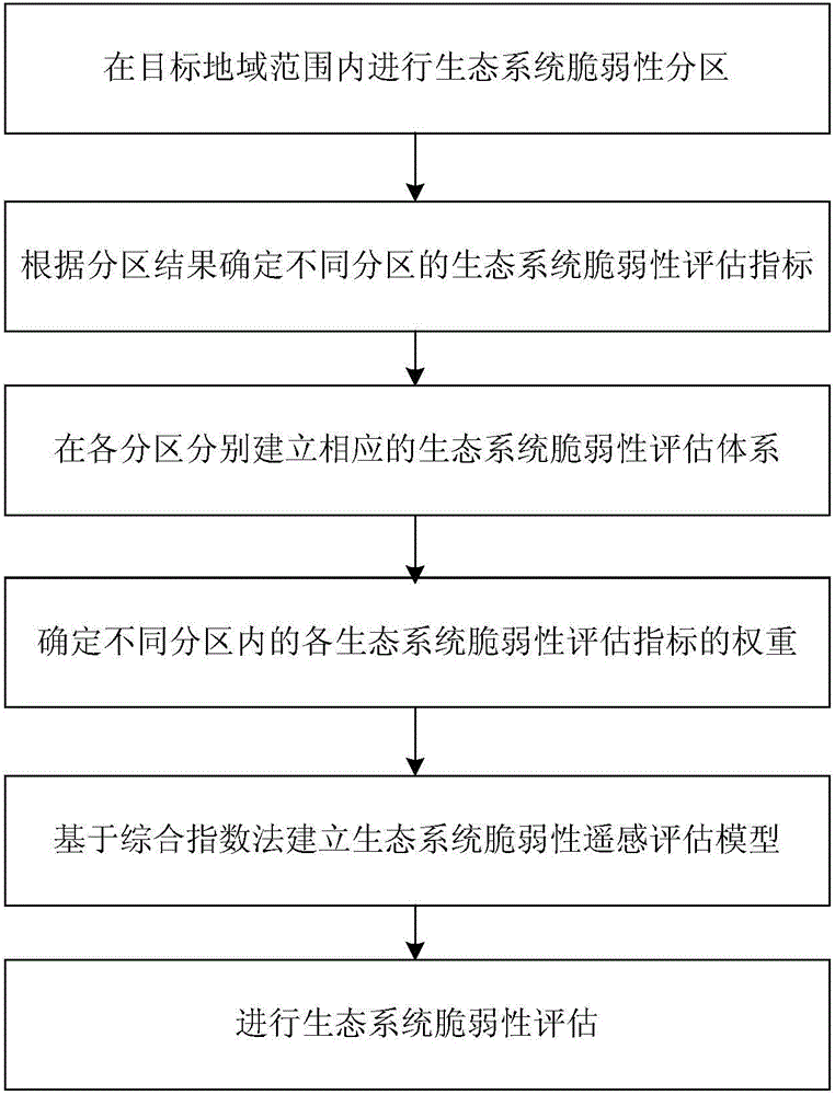
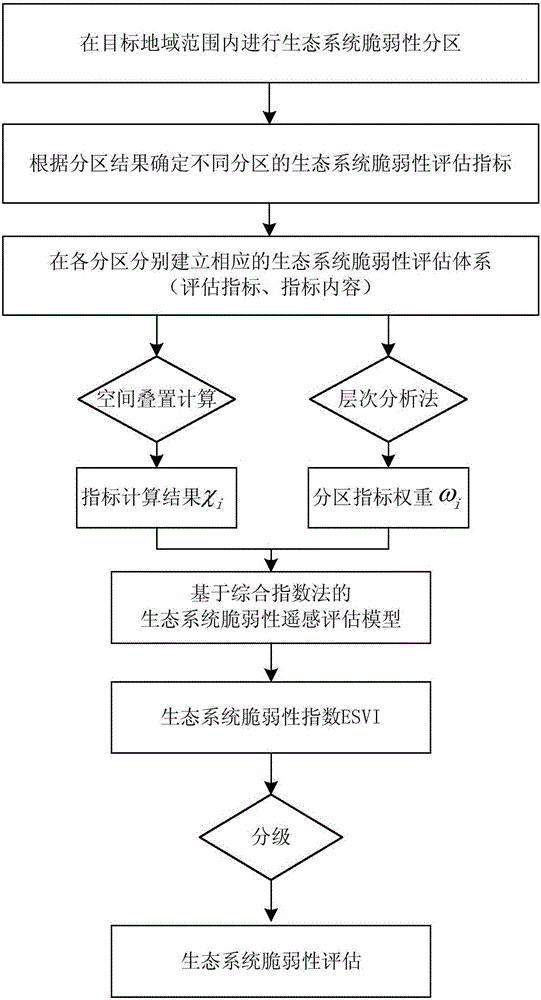
[0047] The invention relates to a remote sensing assessment method for ecosystem vulnerability, the process of which is as follows: figure 1 As shown, by zoning the ecosystem vulnerability within the target area, determining the ecosystem vulnerability assessment indicators for different zones according to the zoning results and establishing corresponding ecosystem vulnerability assessment systems in each zone, and using the AHP to determine the different Based on the weight of each ecosystem vulnerability assessment index in the subregion, the remote sensing assessment model of ecosystem vulnerability is established based on the comprehensive index method, and then the ecosystem vulnerability assessment is carried out.

[0048] The remote sensing evaluation method for ecosystem vulnerability of the present invention will be described in detail below, and the evaluation method...


PUM


Abstract

The invention relates to a remote sensing assessment method and system for ecosystem vulnerability. The method comprises the steps of performing ecosystem vulnerability zoning in a target area range, determining ecosystem vulnerability assessment indexes of different zones according to the zoning result, establishing a corresponding ecosystem vulnerability assessment system in each zone, determining the weights of the ecosystem vulnerability assessment indexes in the different zones by using a hierarchical analysis method, and establishing an ecosystem vulnerability remote sensing assessment model based on a comprehensive index method to assess the ecosystem vulnerability. According to the method, a reasonable ecological environment zoning scheme is formed in the target area range, and a scientific and normative ecosystem vulnerability assessment system, a weight assignment scheme and an assessment model are respectively constructed according to the ecological environment characteristics of the zones to realize intelligent remote sensing assessment of the ecosystem vulnerability, so that the assessment result is accurate and reliable and repeated operation can be implemented.

Description

technical field [0001] The invention relates to the technical field of ecological remote sensing, in particular to a remote sensing assessment method and system for ecological system vulnerability. Background technique [0002] Ecosystem is one of the most basic units constituting the terrestrial ecosphere and an important guarantee for maintaining the sustainable development of society and economy. Since the 20th century, climate warming has intensified, and the global climate and environment have undergone tremendous changes. The loss of species diversity, frequent occurrence of extreme weather events, intensified desertification, and melting of polar glaciers are all strong feedbacks on ecosystem changes. It is a serious threat to the survival of human beings and the sustainable development of social economy. However, under the double coercion of human activities and climate change, population, resource and environmental problems have increasingly become urgent problems ...

Claims


Application Information

Patent Timeline
Patent Type & Authority Applications(China)
IPC IPC(8): G06F19/00
CPCG16Z99/00
Inventor 周艺王世新朱金峰王丽涛刘文亮王福涛
Owner INST OF REMOTE SENSING & DIGITAL EARTH CHINESE ACADEMY OF SCI
Why Eureka
Try Eureka