A multi-source heterogeneous spatial data transfer method based on oracle database

A spatial data, multi-source heterogeneous technology, applied in the database field, can solve problems such as difficult data sharing, multi-source heterogeneous data cannot provide sufficient support, and imperfect distributed processing technology of distributed vector data, etc., to improve efficiency Effect

Active Publication Date: 2020-01-17
CHINESE ACAD OF SURVEYING & MAPPING
View PDF2 Cites 0 Cited by
  • Summary
  • Abstract
  • Description
  • Claims
  • Application Information

AI Technical Summary

Problems solved by technology

Although many solutions have been proposed for spatial data management based on non-relational databases, they are not widely used in commercial applications. The reasons include: the technology of distributed vector data storage, spatial operation and distributed processing is not perfect, Further exploration and research are needed; there is still insufficient support for multi-source heterogeneous data; there is no good solution for how to integrate spatial data in existing relational databases
[0007] At present, most of the domestic database construction does not have a cloud environment, and the more widely used databases are still mainly concentrated in the two aspects of Oracle-based "extended object-relational database" and "spatial data engine". However, many years of database construction have emerged. Many GIS systems with different architectures make it difficult to share data, low data migration efficiency, difficult multi-source heterogeneous data flow, and difficult data interoperability.

Method used


Image

  • A multi-source heterogeneous spatial data transfer method based on oracle database
  • A multi-source heterogeneous spatial data transfer method based on oracle database
  • A multi-source heterogeneous spatial data transfer method based on oracle database

Examples


Embodiment example

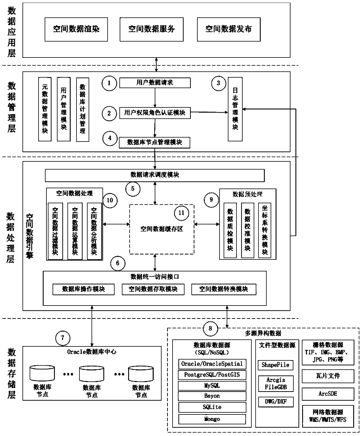
[0130]Based on the NewMap software spatial database engine API, the applicant developed an Oracle data-driven engine (hereinafter referred to as NewMap SDE, referred to as NMSDE) by using the above-mentioned technology. Storage) on the same computer (CPU 8-core 3.6GHz, 4G memory, 100M Ethernet card), the same network bandwidth (100M Ethernet), the same Oracle database server (CPU 8-core 2.40GHz, 16G memory, 100M Ethernet card ) to test storage and query efficiency.

[0131] The experimental data adopts the vector data of March 2016 provided by OpenStreetMap (OSM), Japan in Asia, and the format is Shapefile. The data size is 3.29GB, and there are 8 layers in total, including 2 point layers, 3 line layers and 3 surface layers. The raster data uses TIFF format image data TIFF01 (0.874GB) with 3 bands 18915×15772, IMG format image data IMG01 (1.653GB) with 3 bands 21340×26284 and 30994×72079 image data with 1 band The image data TIFF02 (2.182GB) in TIFF format, the test results a...


PUM


Abstract

The invention discloses a multi-source heterogeneous spatial data transfer method based on an Oracle database. The method includes accepting a data request; determining the database node to be accessed through a spatial data index according to the request; The conversion module converts the spatial data model; performs simple preprocessing on the converted data; stores the data or stores the data after processing. The present invention combines the mature relational database spatial data storage with the spatial database engine technology, and integrates the spatial data in the distributed storage spatial databases by establishing an integrated vector and raster data storage model and optimizing the spatial data retrieval mechanism. Realize the data flow of multi-source heterogeneous data. The Oracle data-driven engine NMSDE developed based on the technology of the present invention is better than ArcSDE in both storage and query efficiency tests.

Description

technical field [0001] The invention relates to the technical field of databases, in particular to a method for transferring multi-source heterogeneous spatial data based on an Oracle database. Background technique [0002] With the continuous development of spatial geographic information technology, the means of obtaining geographic spatial information are constantly enriched. Geospatial data presents the characteristics of diversified data sources, differentiated data models, decentralized data storage, complex spatial relationships, and massive quantities. To this end, various data and application-oriented spatial database technologies, spatial data engine technologies, and distributed storage management technologies have emerged, which have effectively solved the problem of geospatial data storage and management to a certain extent or from a certain aspect. question. [0003] For the storage, organization, management and release of multi-source heterogeneous spatial dat...

Claims


Application Information

Patent Timeline
Patent Type & Authority Patents(China)
IPC IPC(8): G06F16/21G06F16/22G06F16/27G06F16/28
CPCG06F16/214G06F16/2237G06F16/2246G06F16/2282G06F16/27G06F16/284
Inventor 李成名吴政沈建明孙伟洪志远武鹏达方驰宇刘丽
Owner CHINESE ACAD OF SURVEYING & MAPPING
Why Eureka
Try Eureka