Device and method for measuring to-ground height of unmanned aerial vehicle in field of electronic information

A technology of electronic information and measuring devices, applied in the field of electronic information, can solve problems such as low cost of use, large amount of information in image frame data, and small amount of processed information

Active Publication Date: 2017-05-31
广州禹卓勘测技术有限公司
View PDF6 Cites 5 Cited by
  • Summary
  • Abstract
  • Description
  • Claims
  • Application Information

AI Technical Summary

Problems solved by technology

[0002] UAV is an unmanned aircraft controlled by radio remote control equipment or onboard computer program control system. UAV is simple in structure and low in use cost. Tasks play an important role in emergencies and early warning. The height measurement of the ground when the UAV is flying is often an important data to ensure the safety of the flight. The computing power requirements of the processor are naturally high, so the cost of the equipment is greatly increased. Moreover, the camera is usually mainly used for flight aerial photograph

Method used


Image

  • Device and method for measuring to-ground height of unmanned aerial vehicle in field of electronic information
  • Device and method for measuring to-ground height of unmanned aerial vehicle in field of electronic information
  • Device and method for measuring to-ground height of unmanned aerial vehicle in field of electronic information

Examples


Embodiment Construction

[0025]The following will clearly and completely describe the technical solutions in the embodiments of the present invention with reference to the accompanying drawings in the embodiments of the present invention. Obviously, the described embodiments are only some, not all, embodiments of the present invention. Based on the embodiments of the present invention, all other embodiments obtained by persons of ordinary skill in the art without making creative efforts belong to the protection scope of the present invention.

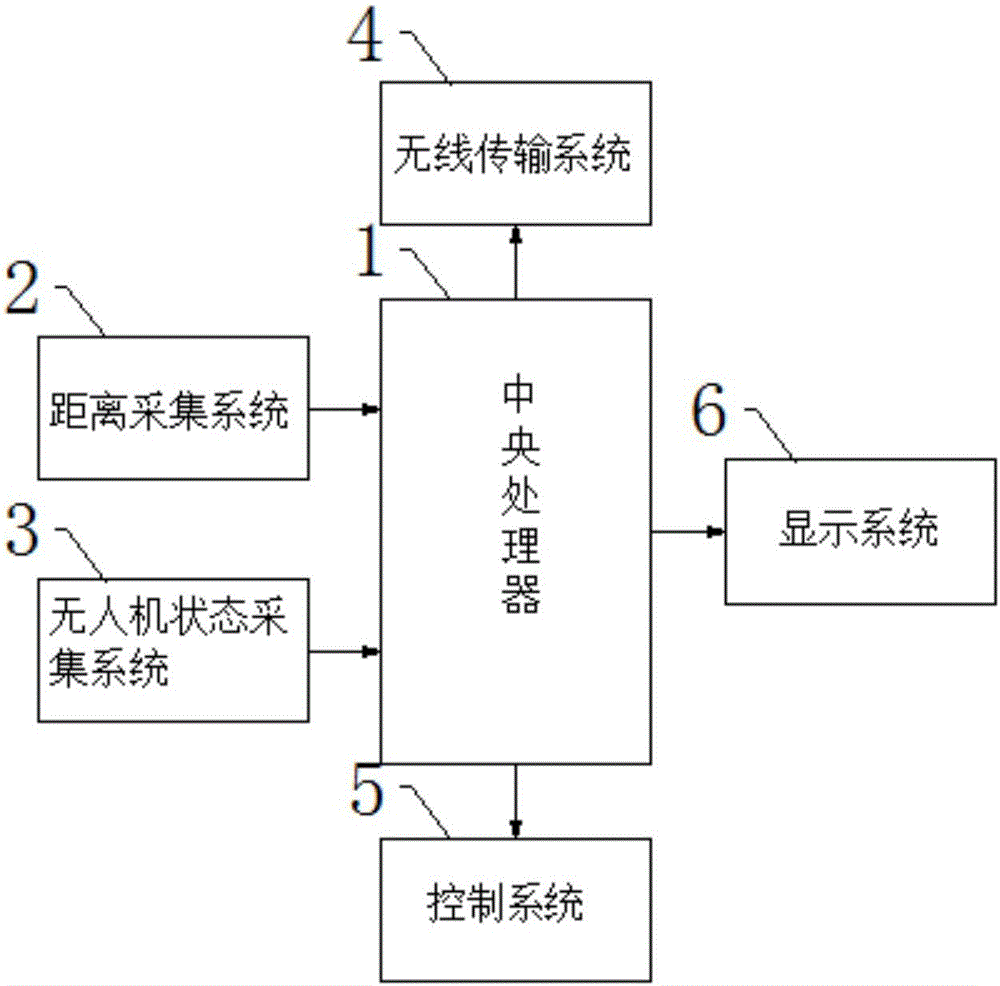
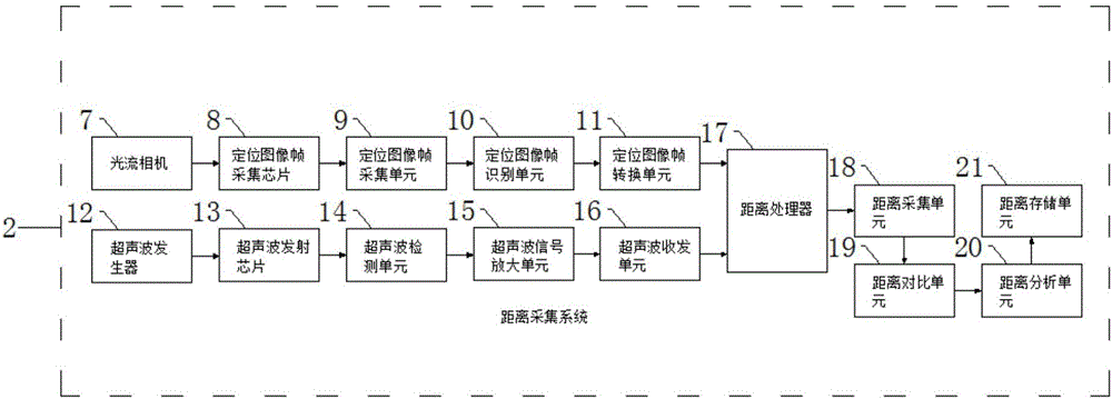
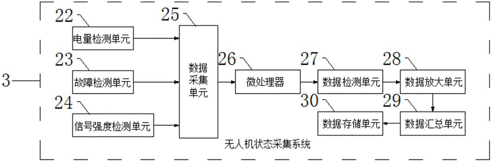
[0026] see Figure 1-7 , the present invention provides a technical solution: a device for measuring the height of an unmanned aerial vehicle to the ground in the field of electronic information, including a central processing unit 1, and the central processing unit 1 is electrically input and connected to the distance acquisition system 2 and the state acquisition of the unmanned aerial vehicle respectively. The system 3 and the central processing unit 1 are r...


PUM


Abstract

The invention discloses a device and a method for measuring a to-ground height of an unmanned aerial vehicle in the field of electronic information, and belongs to the technical field of electronic information. The device comprises a central processing unit, wherein the central processing unit is electrically connected with a distance collecting system and an unmanned aerial vehicle state collecting system in an input manner respectively; the central processing unit is electrically connected with a wireless transmission system, a control system and a display system in an output manner respectively. According to the device and the method, a locating image frame is collected through an optical-flow camera in the distance collecting system; an ultrasonic generator measures the to-ground distance; a distance value and the pixel of the image frame are comprehensively compared and analyzed; the locating coordinate of an aircraft is obtained; the accurate measurement of the to-ground height is obtained; the electric quantity, the failure and the signal intensity of the unmanned aerial vehicle are detected through the unmanned aerial vehicle state collecting system; a control background masters the flight state of the unmanned aerial vehicle in real time; the control information of a controller is transmitted to the unmanned aerial vehicle through the wireless transmission system so as to control the unmanned aerial vehicle.

Description

technical field [0001] The invention relates to the technical field of electronic information, in particular to a device and method for measuring the height of an unmanned aerial vehicle to the ground in the field of electronic information. Background technique [0002] UAV is an unmanned aircraft controlled by radio remote control equipment or onboard computer program control system. UAV is simple in structure and low in use cost. Tasks play an important role in emergencies and early warning. The height measurement of the ground when the UAV is flying is often an important data to ensure the safety of the flight. The computing power requirements of the processor are naturally high, so the cost of the equipment has increased significantly. Moreover, the camera is usually mainly used for flight aerial photography. Technically, the optical flow camera (the principle is the same as the photoelectric sensor for mouse displacement detection) is used to replace the traditional ca...

Claims


Application Information

Patent Timeline
IPC IPC(8): G01C5/00G05B19/042
CPCG01C5/005G05B19/0423
Inventor 孙永智
Owner 广州禹卓勘测技术有限公司
Why Eureka
Try Eureka