

Method for estimating exploitation and utilization actualities of underground spaces on basis of multiple urban geographic data
An underground space and geographic data technology, applied in geographic information databases, data processing applications, special data processing applications, etc., can solve the problem of insufficient specific and accurate values, and achieve the effect of ensuring accuracy, avoiding incalculability, and avoiding work confusion.
- Summary
- Abstract
- Description
- Claims
- Application Information
AI Technical Summary
Problems solved by technology
Method used
Image

Examples
Embodiment Construction
[0046]The specific implementation manners of the present invention will be further described below in conjunction with the drawings and examples. The following examples are only used to illustrate the technical solution of the present invention more clearly, but not to limit the protection scope of the present invention.
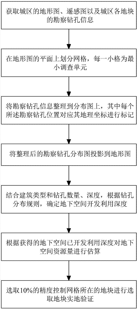
[0047] In one embodiment, the method for estimating the status quo of underground space development and utilization based on a variety of urban geographic data of the present invention, figure 1 As shown, the estimation method of this embodiment at least includes the following steps:
[0048] Step 1. Collect urban topographic maps, remote sensing images, and survey control drilling information for each plot.
[0049] In a specific embodiment, the collected topographic map is a 1:10000 topographic map, and the remote sensing picture is a 1:2000 remote sensing picture; the survey report records the location, quantity and depth of the survey control drilling ...
PUM
 Abstract
Description
Claims
Application Information