PSInSAR deformation estimation method applicable to complex urban area infrastructure in windy and rainy conditions

A technology of infrastructure and conditions, which is applied in the field of PSInSAR estimation to achieve the effects of improving accuracy, robustness and fit.

Inactive Publication Date: 2017-07-11
洪都天顺(深圳)科技有限公司
View PDF1 Cites 39 Cited by
  • Summary
  • Abstract
  • Description
  • Claims
  • Application Information

AI Technical Summary

Problems solved by technology

[0015] In order to solve the above-mentioned technical problems, the present invention provides a PSInSAR deformation estimation method of complex urban infrastructure under cloudy and rainy conditions, which realizes the joint calculation of single PS points and overlapping PS points without the need to remove the atmosphere g

Method used


Image

  • PSInSAR deformation estimation method applicable to complex urban area infrastructure in windy and rainy conditions
  • PSInSAR deformation estimation method applicable to complex urban area infrastructure in windy and rainy conditions
  • PSInSAR deformation estimation method applicable to complex urban area infrastructure in windy and rainy conditions

Examples


Embodiment Construction

[0048] In order to make the object, technical solution and advantages of the present invention clearer, the present invention will be further described in detail below in conjunction with the accompanying drawings and embodiments. It should be understood that the specific embodiments described here are only used to explain the present invention, not to limit the present invention.

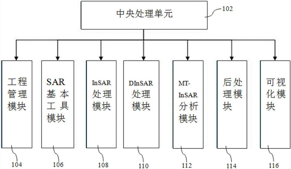
[0049] An embodiment of the present invention provides a method for PSInSAR deformation estimation of complex urban infrastructure under cloudy and rainy conditions, comprising the following steps:

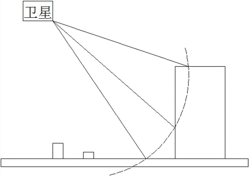
[0050] Preprocess the time-series SAR image to obtain the image data of differential interferometry;

[0051] Use amplitude deviation threshold method or coherence coefficient threshold method or intensity method to extract the single PS point candidate points of Delaunay triangulation network from the differential interferometry image data, connect each single PS point candidate points and carry out a...


PUM


Abstract

The invention relates to the technical field of synthetic aperture radar interferometry, and specifically relates to a PSInSAR estimation method applicable to complex urban area infrastructure in windy and rainy conditions. The method includes following steps: performing data preprocessing on InSAR data; establishing a Delaunay triangulation network and an adaptive encryption network; estimating an arc segment relative parameter through a robust estimator; performing Tikhonov regularization adjustment operation; establishing a local star network; recognizing single PS points and layover PS points; calculating the single PS points in remaining pixels through the robust estimator, and detecting the layover PS points through a compressed sensing algorithm; and outputting heights and deformation results of the single PS points and the layover PS points. According to the method, combined calculation of the single PS points and the layover PS points is realized through mixed network establishment without removing the atmosphere in a global manner, a temperature non-linear deformation model is introduced, the fitting degree of the time sequence phase is improved, accurate estimation of the PS points is realized by employing the robust estimator, and the layover PS points of the complex urban environment are extracted by employing super-resolution MD-TomoSAR imaging.

Description

technical field [0001] The invention relates to the technical field of synthetic aperture radar interference, in particular to a PSInSAR estimation method suitable for complex urban infrastructure under cloudy and rainy conditions. Background technique [0002] Urban infrastructure (including roads, buildings, railways, bridges, dams, airports, etc.) is an important part of the urban environment, and the structural safety of infrastructure is directly related to the sustainable development of the urban environment and social economy. [0003] However, in recent years, ground subsidence and infrastructure deformation caused by groundwater extraction, underground space development, and soft soil deposition have become increasingly serious, resulting in structural deformation and damage to infrastructure, and even casualties, such as the March 2013 Shenzhen The ground subsidence incident caused 1 death. In April 2014, the collapse of a building in Fenghua, Zhejiang Province cau...

Claims


Application Information

Patent Timeline
IPC IPC(8): G01S13/90
CPCG01S13/9023
Inventor 马培峰林晖杨侨聪严伟叶关根
Owner 洪都天顺(深圳)科技有限公司
Why Eureka
Try Eureka