Outdoor construction method based on UAV photography technology and BIM technology

A construction method and unmanned aerial vehicle technology, applied in the direction of image data processing, special data processing applications, instruments, etc., can solve the problems of increased workload, tight construction period, and heavy measurement workload, so as to ensure project quality and reduce labor costs and the effect of time cost

Active Publication Date: 2017-08-18
CHINA MCC17 GRP
View PDF3 Cites 56 Cited by
  • Summary
  • Abstract
  • Description
  • Claims
  • Application Information

AI Technical Summary

Problems solved by technology

[0011] However, in the above calculation methods, there are still the following defects: the earthwork survey of the grid method requires the measurement of the elevation of the grid nodes, which requires the grid layout in advance, and then measures the node elevation, which greatly increases the w

Method used


Image

  • Outdoor construction method based on UAV photography technology and BIM technology

Examples


Embodiment Construction

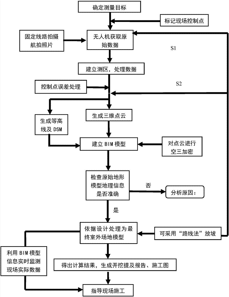
[0033] In order to further describe the present invention, the present invention will be further described below in conjunction with the embodiments and accompanying drawings.

[0034] As shown in the figure, combined with the example of Lanzhou Modern Vocational College Project landscape lake greening earthwork construction, the project covers an area of ​​about 182.36 hectares (about 2,735.37 acres), and the planned construction area is about 1,099,800 square meters. Mainly construct teaching buildings, libraries, indoor sports centers, student dormitories, canteens, administrative offices, logistics and auxiliary buildings, etc. Municipal supporting facilities such as roads, water, electricity, gas, heating, and greening will be constructed at the same time.

[0035] Take one of them as the target area.

[0036] 1. Obtain raw data through drones

[0037] 1.1 Set the parameters of the aircraft, the height of the aircraft from the ground (70m); the angle between the camera l...


PUM


Abstract

The present invention discloses an outdoor construction method based on a UAV photography technology and a BIM technology. The method comprises the following steps: 1) acquiring UAV field data; 2) performing data processing by using corresponding software; 3) establishing a BIM information model; 4) by applying a BIM technology, performing sloping according to different sites and designs; and 5) designing a BIM site model. The method disclosed by the present invention has the following advantages: manpower cost and time cost of measurement are greatly reduced; on-site terrain data is acquired in real time, which is convenient and quick; by combining BIM, on-site construction is provided with a visualized three-dimensional model and precise data at each stage, such as excavation volume reports, construction drawings and spatial information, so as to ensure implementation of project quality.

Description

technical field [0001] The invention relates to the field of earthwork measurement and construction technology, in particular to an outdoor construction method based on unmanned aerial vehicle photography technology and BIM technology, which is suitable for construction land with fewer buildings and a wider site, and for large-scale infrastructure projects, road and bridge projects should be applicable. Background technique [0002] In large-scale and large-scale infrastructure projects, the outdoor project will undoubtedly look at the entire site and play a decisive role in the image of the project. Therefore, in order to reasonably arrange the project progress, accurately calculate the project cost, and improve the project quality, it is usually necessary to be efficient, Accurately calculate site earthwork volume. The quality and efficiency of earthwork measurement will bear a large weight in the project, which directly affects the cost and progress of the project, and a...

Claims


Application Information

Patent Timeline
IPC IPC(8): G06F17/50G06T17/10
CPCG06F30/13G06F30/20G06T17/10
Inventor 王佳禧刘宇刘生强杜文静
Owner CHINA MCC17 GRP
Why Eureka
Try Eureka