Plot scale based remote-sensing monitoring method for dynamic area change of crops

A technology of remote sensing monitoring and dynamic change, applied in measurement devices, image data processing, instruments, etc., can solve the problems of difficult to achieve results, difficult to achieve consistency, large differences in patterns, etc., to improve monitoring accuracy and monitoring efficiency, The effect of reducing the source of remote sensing monitoring errors and reducing manual workload

Inactive Publication Date: 2017-08-22
HUBEI UNIV
View PDF4 Cites 15 Cited by
  • Summary
  • Abstract
  • Description
  • Claims
  • Application Information

AI Technical Summary

Problems solved by technology

But in fact, the current remote sensing classification results often have many sources of error, such as image imaging time, resolution, image quality, human interference, etc. For images in the same area, different people or differen

Method used


Image

  • Plot scale based remote-sensing monitoring method for dynamic area change of crops

Examples


Embodiment 1

[0024] Embodiment 1: In the embodiment of the present invention, professional software such as ARCGIS, ERDAS IMAGE, ENVI are used in conjunction with development tools such as ArcGIS Engine or ArcGIS Object, Visual Studio to implement and complete.

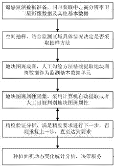
[0025] Such as figure 1 Shown: the method for remote sensing monitoring of dynamic changes in crop planting area based on the plot scale in the embodiment of the present invention, which includes the following steps:

[0026] S1. Remote sensing monitoring data preparation, while obtaining medium and high resolution satellite image data and other basic data. Basic data of the monitoring area, including administrative division maps, historical maps, statistical data, etc. Query the satellite image data of the monitoring area, and obtain the image data source through purchase or free download. If the 1-2m high-resolution image data and higher-resolution image data cannot be obtained for free, the monitoring area data should be appr...


PUM


Abstract

The invention discloses a plot scale based remote-sensing monitoring method for dynamic area change of crops, and belongs to the field of agricultural information application. According to the method, dynamic area change of crops is monitored by combining spatial data, as a basic monitoring data, of the plot scale of cultivated land with real-time satellite image data in the growing period of the crops. A satellite remote-sensing monitoring technology replaces a ground investigation method to certain extent to obtain patch data and attribute information of the cultivated land in the monitoring period, and the general change tread of the plantation area of the crops is analyzed according to the obtained information. The method is mainly based on the 3S technology, the accuracy of high-resolution image data and the timeliness of intermediate and high resolution image data are utilized fully, the plantation area of the crops can be extracted accurately, error sources in the remote-sensing interpretation process are reduced, the labor workload of ground investigation is reduced, the present situation that outdoor investigation is large in the workload and indoor remote-sensing monitoring is large is errors at present can be changed to certain extent, and the new technical scheme is provided for monitoring the dynamic change of the plantation area of the crops.

Description

technical field [0001] The invention relates to the field of agricultural information applications, in particular to a remote sensing monitoring method for dynamic changes in crop area based on plot scale. Background technique [0002] At present, the agricultural remote sensing monitoring method is mainly a method based on remote sensing image sampling combined with ground survey. The crop planting area information in remote sensing image is extracted by extracting remote sensing classification technology, so as to monitor the change trend of crop area. But in fact, the current remote sensing classification results often have many sources of error, such as image imaging time, resolution, image quality, human interference, etc. For images in the same area, different people or different classification methods, the extracted result patterns are often The differences are large, and it is difficult to reach a consensus. It is difficult to achieve ideal results by using such dat...

Claims


Application Information

Patent Timeline
IPC IPC(8): G01B11/28G06T7/62
CPCG01B11/28G06T2207/10032G06T2207/30188
Inventor 陈志杰汪权方
Owner HUBEI UNIV
Why Eureka
Try Eureka