Automatic generation system of ground line data

An automatic generation and data processing system technology, applied in the field of surveying and mapping, can solve the problems of low accuracy of surveying and mapping results, difficulty in guaranteeing the construction period, and increased survey costs, and achieve the effects of saving field survey costs, improving efficiency, and improving efficiency

Pending Publication Date: 2017-08-22
SHANGHAI HUACE NAVIGATION TECH
View PDF7 Cites 5 Cited by
  • Summary
  • Abstract
  • Description
  • Claims
  • Application Information

AI Technical Summary

Problems solved by technology

However, this method uses single-point contact measurement, which leads to a slow operation speed. At the same time, due to the limitations of natural conditions such as weather, traffic, and diffi

Method used


Image

  • Automatic generation system of ground line data

Examples


Embodiment Construction

[0023] In the following description, a lot of specific details are given in order to provide a more thorough understanding of the present invention. However, it is obvious to those skilled in the art that the present invention can be implemented without one or more of these details. In other examples, in order to avoid confusion with the present invention, some technical features known in the art are not described.

[0024] In order to thoroughly understand the present invention, detailed steps and detailed structures will be presented in the following description to explain the technical solution of the present invention. The preferred embodiments of the present invention are described in detail as follows. However, in addition to these detailed descriptions, the present invention may also have other embodiments.

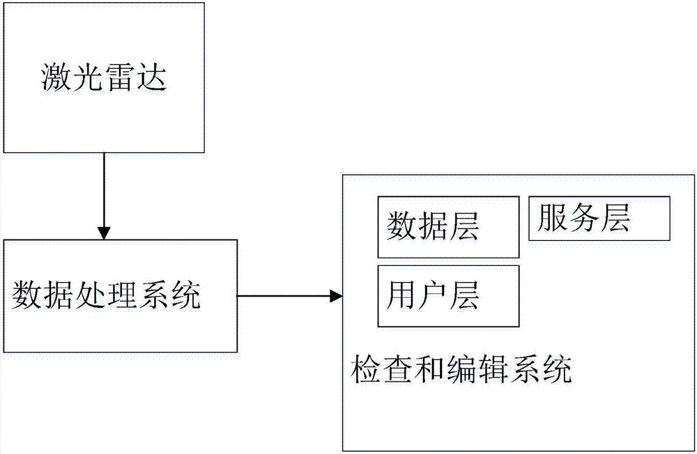
[0025] Reference figure 1 As shown, the present invention provides an automatic generation system for ground line data, including:

[0026] Lidar, the lidar is used to...


PUM


Abstract

The invention provides an automatic generation system of ground line data. The system comprises a laser radar, a data processing system and a checking and editing system; the laser radar obtains point cloud data of a ground line; the data processing system processes the obtained point cloud data, carries out data modeling and elevation interpolation according to ground type points in the point cloud data to obtain the ground line; and the checking and editing system drafts the obtained ground line in a visual graph environment, checks the edits the generated ground line visually by overlapping LiDAR point cloud and DOM data, and generates ground line data finally. The system can extract the designed ground line rapidly and automatically, and integrate laser radar measurement with road production drawing design; and in an area with many structures, the ground line generated by the system reflects real land surface information of micro-landforms more accurately compared with that via a digital-analog interpolation method.

Description

Technical field [0001] The invention relates to the field of surveying and mapping, in particular to an automatic generation system for ground line data. Background technique [0002] At present, the efficiency and accuracy of obtaining ground line information in highway survey and design are low. The current mainstream method is to use total station or real-time differential positioning technology (rael-time kinematic, RTK) to stake out the middle pile first, and then use RTK to measure the elevation of each cross section. However, this method uses single-point contact measurement, resulting in slower operation speed. At the same time, due to natural conditions such as weather, traffic and terrain difficulties in the survey area, it is easy to cause low accuracy of surveying and mapping results, difficult to guarantee the construction period, and survey costs. Increased adverse consequences. Summary of the invention [0003] In order to solve the above technical problems, the p...

Claims


Application Information

Patent Timeline
IPC IPC(8): G01S17/89
CPCG01S17/89
Inventor 赵延平朴东国何伟王杰俊王安邦
Owner SHANGHAI HUACE NAVIGATION TECH
Why Eureka
Try Eureka