Highway survey and design method based on airborne lidar data

A survey design and data technology, applied in the fields of surveying and mapping and highway survey, can solve the problems of unguaranteed accuracy and quality requirements, reduced highway survey and design efficiency, and high cost of highway survey work, avoiding loss of accuracy, high practicability, Easy to achieve effects

Active Publication Date: 2016-11-23
HENAN PROVINCIAL COMM PLANNING & DESIGN INST CO LTD
View PDF2 Cites 0 Cited by
  • Summary
  • Abstract
  • Description
  • Claims
  • Application Information

AI Technical Summary

Problems solved by technology

At present, although LiDAR equipment and technology have been introduced in China, and have been applied in highway survey and route selection and route design, most of them still need to use mature LiDAR data processing software to obtain DEM, DOM and DLG products first, and then These data processing products are imported into the design software for highway survey and longitudinal and cross-section design. In this way, due to the increase in data processing, the accuracy of the measurement results will inevitably be affected. At the same time, the process of highway survey will be increased and the cost of highway survey will be reduced. design efficiency
In addition, the existing design and generation of highway longitudinal and cross-sections often do not comprehensively consider various factors and requirements, which easily leads to high cost of highway survey work, long construction period, and the accuracy and quality requirements cannot be guaranteed.

Method used


Image

  • Highway survey and design method based on airborne lidar data

Examples


Embodiment 1

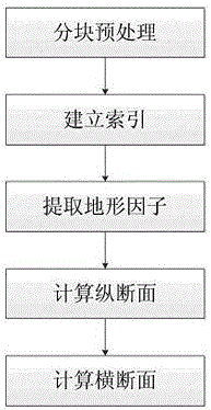
[0033] Example 1, such as figure 1 As shown, a highway survey and design method based on airborne LiDAR data includes the following steps:

[0034] Step 1), perform block preprocessing on the LiDAR data, this step further includes the following sub-steps:

[0035] ① Obtain the coordinate range of LiDAR data by traversing LiDAR data or querying metadata;

[0036] ②Set the appropriate grid size of LiDAR data blocks, such as 1KM*1KM;

[0037] ③ Calculate the range of each block according to the size of the LiDAR data block, and calculate the file name stored in each block accordingly, and store the point cloud within the range as a file. This method uses an incremental method for mesh division.

[0038] Newlat=Lat+AddLat

[0039] Newlon=Lon+AddLon

[0040] In the formula, NewLat and NewLon are the coordinates of the lower right corner of the current grid, Lat and Lon are the coordinates of the lower right corner of the previous grid, and AddLat and AddLon are the increments ...


PUM


Abstract

The invention belongs to a road survey and design method based on airborne LiDAR data. The method includes the following steps that (1) blocking pre-processing is carried out on the LiDAR data, (2) indexes of the LiDAR data are built, (3) terrain factors of the LiDAR data are extracted, (4) the vertical section of a road is calculated, and (5) the cross section of the road is calculated. According to the method, the LiDAR data are directly used as original data, and the needed vertical section and the needed cross section in road design are calculated, so that the vertical section and the cross section of the road are directly generated by means of the LiDAR data, the steps of generating a DOM and a DEM are omitted, precision loss caused by data processing is avoided, efficiency of road survey and design is improved, time of road survey and design is shortened, meanwhile, influences of landform on the vertical section and the cross section are taken into consideration, influences of natural terrain, geology, hydrology, climate and other factors along the road on road survey and design are comprehensively considered, the method can automatically adapt to changes of the terrain, practicability of the method is high, and the method is easy to achieve and meets requirements of the road survey and design industry.

Description

technical field [0001] The invention belongs to the technical field of surveying and mapping and highway survey, in particular to a road survey and design method based on airborne LiDAR data. Background technique [0002] LiDAR—Light Detection And Ranging, that is, light detection and measurement. It uses GPS (Global Position System) and IMU (Inertial Measurement Unit, inertial measurement unit) airborne laser scanning. The measured data is a discrete point representation of the Digital Surface Model (DSM), which contains spatial three-dimensional information and laser intensity information. LiDAR is roughly divided into two categories: airborne and ground. Among them, airborne lidar is an airborne laser detection and ranging system installed on an aircraft, which can measure the three-dimensional coordinates of ground objects. Airborne LiDAR is an active earth observation system, which is an emerging technology first developed by western countries and put into commercial ...

Claims


Application Information

Patent Timeline
Patent Type & Authority Patents(China)
IPC IPC(8): G01S13/88
CPCG01S17/88
Inventor 王世杰马捷苏沛东陈金旺万进杜占军马松江马炅万继志付大喜楚斌康健
Owner HENAN PROVINCIAL COMM PLANNING & DESIGN INST CO LTD
Why Eureka
Try Eureka