Vehicle laser radar three-dimensional scanning method, and terrain classification method and system

A vehicle-mounted laser radar and three-dimensional scanning technology, which is applied in the field of vehicle-mounted color three-dimensional scanning laser radar solutions, can solve the problems that the accuracy effect is not suitable for market development, it is difficult to obtain the spectral characteristics of ground objects, and the data processing is complicated, etc., to achieve enhanced color resolution, The effect of improving the ability of ground detection

Active Publication Date: 2017-08-25
天津珞雍空间信息研究院有限公司
View PDF5 Cites 16 Cited by
  • Summary
  • Abstract
  • Description
  • Claims
  • Application Information

AI Technical Summary

Problems solved by technology

However, due to the limitation of a single wavelength of traditional lidar, it is difficult to obtain effective spectral features of ground objects, and spectral information can effectively express the attributes of ground objects
Usually it is necessary to match a panoramic camera to detect at the same time to obtain the corresponding texture and color spectrum information, but the cost is too high, the subsequent data processing is complicated, and the accuracy effect is no longer suitable for market development needs

Method used


Image

  • Vehicle laser radar three-dimensional scanning method, and terrain classification method and system
  • Vehicle laser radar three-dimensional scanning method, and terrain classification method and system
  • Vehicle laser radar three-dimensional scanning method, and terrain classification method and system

Examples


Embodiment Construction

[0036] The technical solution of the present invention will be described in detail below in conjunction with the drawings and embodiments.

[0037] The present invention proposes, aiming at vehicle-mounted radar remote sensing technology, overcomes the prejudice of the prior art and changes the existing single-wavelength laser radar technology into a three-color synthetic color laser wavelength in the visible light range, or adopts continuous white light laser to make its detection data have a color spectrum Echo intensity and angle, distance information. Under new equipment conditions, performing corresponding detection processing is also the research scope of the present invention.

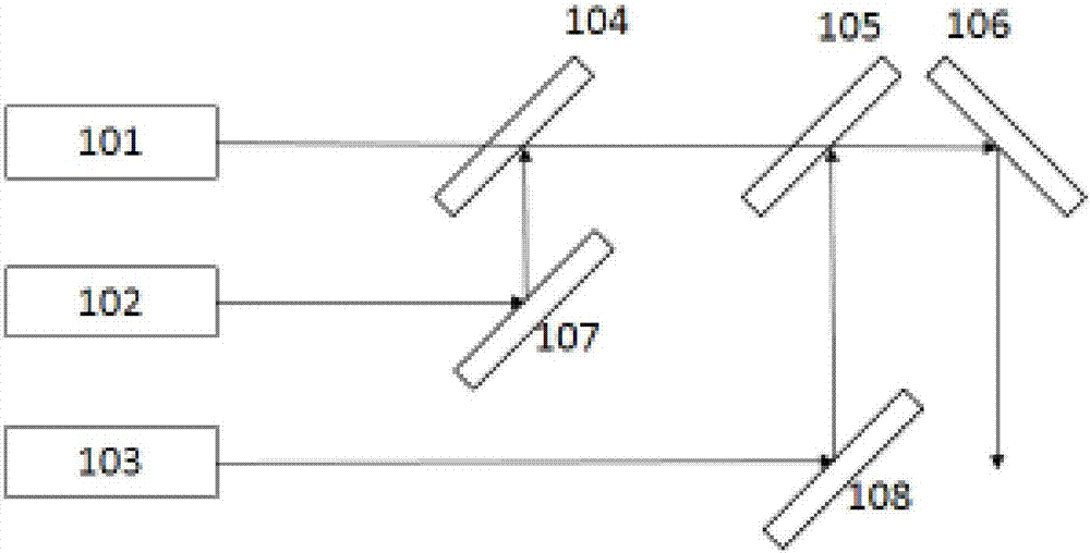
[0038] If the method of three-color synthesis is adopted, red, green and blue lasers with wavelength ranges of 600-700nm, 490-580nm, and 490-450nm are preferably used, which are combined through multiple dichroic mirrors.

[0039] The 3D color laser scanning imaging detection combined with 3D s...


PUM


Abstract

The invention provides a vehicle laser radar three-dimensional scanning method, and a terrain classification method and system. A laser emission unit, a signal detection unit, a POS unit and a core processing unit are arranged on a vehicle, wherein the laser emission unit comprises a colorful laser source, an acquisition result of the signal detection unit is inputted to the core processing unit, point cloud acquired through scanning is acquired, the colorful spectrum information of the point cloud is acquired, and the relative geometric position of the point cloud is determined; the attitude position information is further recorded by the POS unit and is inputted to the core processing unit, according to the relative attitude of the laser emission unit and the POS unit, the absolute geometric position of the point cloud is acquired based on the relative geometric position of the point cloud, and the space position information of the point cloud is acquired. The vehicle laser radar three dimensional scanning method is advantaged in that the colorful laser spectrum information of a target terrain and the laser point cloud space information are directly and simultaneously acquired, so colorful laser imaging of the target terrain is acquired through three-dimensional reconstruction, and the method can be widely applied to the digital city and smart city fields.

Description

technical field [0001] The invention relates to the technical field of comprehensive application of mobile measurement and surveying and mapping remote sensing, in particular to a vehicle-mounted color three-dimensional scanning laser radar solution, which can simultaneously acquire color spectrum information and three-dimensional space information of target ground objects on a mobile vehicle platform. Background technique [0002] Vehicle-mounted earth observation lidar technology is an important remote sensing method to achieve high spatial resolution three-dimensional space description of ground objects in road environment, especially in urban environment, it has outstanding advantages in quickly obtaining three-dimensional space information. However, due to the limitation of a single wavelength of traditional lidar, it is difficult to obtain effective spectral features of ground objects, and spectral information can effectively express the attributes of ground objects. I...

Claims


Application Information

Patent Timeline
Patent Type & Authority Applications(China)
IPC IPC(8): G01S17/89G01S7/481
CPCG01S7/481G01S17/89
Inventor 龚威陈必武宋沙磊史硕陈振威
Owner 天津珞雍空间信息研究院有限公司
Why Eureka
Try Eureka