Air/space/boat/buoy/island-reef based waters multi-sensor integrated monitoring system
What is Al technical title?
Al technical title is built by PatSnap Al team. It summarizes the technical point description of the patent document.
A monitoring system, multi-sensor technology, used in aerospace, aviation, navigation and information fields
Pending Publication Date: 2017-09-05
XIAN FEISIDA AUTOMATION ENG
View PDF4 Cites 36 Cited by
Summary
Abstract
Description
Claims
Application Information
AI Technical Summary
This helps you quickly interpret patents by identifying the three key elements:
Problems solved by technology
Method used
Benefits of technology
Problems solved by technology
[0005] In order to solve the technical problem that it is difficult to cover and focus on monitoring and obtaining accurate dynamic data, the present invention provides a multi-sensor integrated monitoring system for sky/air/ship/buoy/island and reef-based sea area, which uses satellite SAR images for passive positioning , UAVs use multi-sensor special surveillance pods such as radar/image/ultrasound, unmanned ships use search radar/image/ultrasound/laser integrated monitoring systems, island reef bases and shore bases use ADS-B/AIS/radar/ Panorami
Method used
Image
Click on the blue label to locate the original text in one second.
Reading with bidirectional positioning of images and text.
Examples
Embodiment Construction
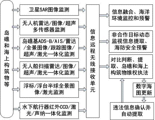
[0019] Refer to attached figure 1 .
[0020] Step 1: In view of the lack of obvious feature points of maritime targets, the difficulty of obtaining ground control points, and the difficulty of online precise positioning of maritime ship targets with image data; a robust prediction and estimation algorithm aimed at the center of the earth is used to suppress space-based errors, time Datum error, calculation error of earth rotation and revolution, location accumulation error of sea surface target caused by map large-area matching prediction, error of remote sensing image and remote image;
[0021] Step 2: (1) Install a radar / image / ultrasonic multi-sensor hemispherical surveillance pod on the UAV platform. One CCD achieves full coverage of the monitored range; at the same time, considering the requirements of key monitoring, according to the area coverage requirements of a given distance and the field of view angle of different distances of the motorized lens, a group of CCDs on...
PUM
Abstract
In order to solve the technical problems of difficulties in coverage and intensive monitoring to obtain accurate dynamic data, the invention provides an air/space/boat/buoy/island-reef based waters multi-sensor integrated monitoring system. In this system, the satellite SAR image passive positioning is used, an unmanned aerial vehicle (UAV) adopts a radar/image/ultrasound and other multi-sensor dedicated monitoring pod, an unmanned boat adopts a search radar/image/ultrasound/laser integrated monitoring system, the island-reef base and shore base adopt an ADS-B/AIS/radar/panoramic image/tracking image/ultrasonic/laser integrated monitoring system, a buoy/floating platform adopts a hemispherical panoramic image/laser system, an underwater vehicle adopts a multi-channel infrared CCD/ultrasonic and sonar monitoring system, a comprehensive analysis system is established at the background to obtain illegal, air and sea non-cooperation objectives on island reefs and offshore structures and comprehensive marine environmental information, and the technical problems of difficulties in coverage and intensive monitoring to obtain accurate dynamic data monitoring are solved.
Description
technical field [0001] The invention relates to satellites, unmanned aerial vehicles, unmanned ships, underwater vehicles, buoys / pontoons, island-reef (shore)-based platforms, and sensor systems such as ADS-B, AIS, radar, image, laser, infrared, and ultrasound. It particularly relates to a sky / air / ship / buoy / island and reef-based multi-sensor integrated monitoring system, which belongs to the fields of aviation, aerospace, navigation and information technology. Background technique [0002] Usually, on-site information on rights protection and law enforcement such as islands, reefs and offshore structures are obtained through shore-based monitoring stations, roving monitoring ships, satellite remote sensing and optical images, etc., which are difficult to cover and focus on monitoring to obtain accurate dynamic data; due to historical and practical reasons, my country The encroachment on islands and reefs is serious, and territorial sovereignty has been continuously damaged by...
Claims
Application Information
Patent Timeline
Application Date:The date an application was filed.
Publication Date:The date a patent or application was officially published.
First Publication Date:The earliest publication date of a patent with the same application number.
Issue Date:Publication date of the patent grant document.
PCT Entry Date:The Entry date of PCT National Phase.
Estimated Expiry Date:The statutory expiry date of a patent right according to the Patent Law, and it is the longest term of protection that the patent right can achieve without the termination of the patent right due to other reasons(Term extension factor has been taken into account ).
Invalid Date:Actual expiry date is based on effective date or publication date of legal transaction data of invalid patent.