City land mixed utilization characteristic grid calculating method and device

A grid and land technology, applied in the field of information processing, can solve problems such as difficult to better reflect the most real urban space, and achieve the effects of strong timeliness, large amount of data, and timely updates

Active Publication Date: 2017-09-05
CHINA AGRI UNIV
View PDF5 Cites 10 Cited by
  • Summary
  • Abstract
  • Description
  • Claims
  • Application Information

AI Technical Summary

Problems solved by technology

[0007] The present invention provides a method and device for calculating the characteristic grid of urban land mixed utilization, which is used to solve the problem that it is difficult to better reflect the most real urban space status in the prior art

Method used


Image

  • City land mixed utilization characteristic grid calculating method and device
  • City land mixed utilization characteristic grid calculating method and device
  • City land mixed utilization characteristic grid calculating method and device

Examples


Embodiment Construction

[0049]The specific implementation manners of the present invention will be further described in detail below in conjunction with the accompanying drawings and embodiments. The following examples are used to illustrate the present invention, but are not intended to limit the scope of the present invention.

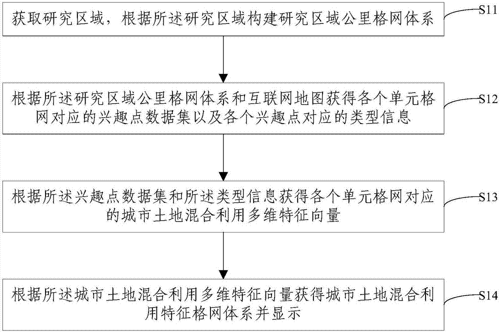
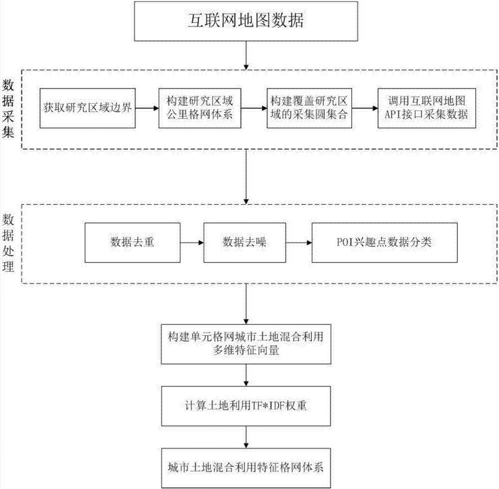
[0050] figure 1 and figure 2 It shows that Embodiment 1 of the present invention provides a grid calculation method for urban land mixed-use characteristics, including:

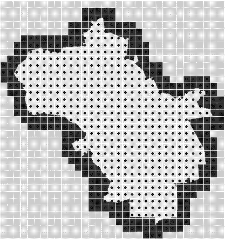
[0051] S11. Obtain the research area, and construct the kilometer grid system of the research area according to the research area.

[0052] In this step, it should be noted that the research area must first be obtained. For the acquisition of the research area, in the embodiment of the present invention, the set of boundary points of the research area can be obtained through the Internet map API interface. Specifically, there are two cases of obtaining boundary point sets, as follows:

[0053] a: The ...


PUM


Abstract

The invention provides a city land mixed utilization characteristic grid calculating method and device. The city land mixed utilization characteristic grid calculating method comprises steps of obtaining a research area and constructing a research area kilometer grid system according to a research area, obtaining an interest point data set corresponding to each unit grid and an information type corresponding to each interest point according to a kilometer grid system and an internet map, obtaining a city land mixed utilization multi-dimension characteristic vector corresponding to each unit grid according to the interest point data set and the information type, and obtaining a city land mixed utilization characteristic grid system and displaying according to the city land mixed utilization multi-dimension vector. The city land mixed utilization characteristic grid calculating method and device use internet map data in a city scope which is massive, updates timely and has strong timeliness, solve problems that the timeliness is poor and difference exists between data and a real urban space because of traditionally adopting city planning, land investigation and data statistics as data basis, and can meet the demand for multi-scale research and analysis from a small scale to a big scale.

Description

technical field [0001] The invention relates to the technical field of information processing, in particular to a method and device for calculating characteristic grids of urban land mixed utilization. Background technique [0002] In the past 30 years, in the process of my country's rapid urbanization, long-term emphasis has been placed on the intensive use of urban land, and urban functional zoning and land use models with a single nature have been clarified. Segmented and relatively closed urban spatial morphological characteristics. This division of spatial form coincides with the rapid growth of private cars in big cities, which has caused serious traffic congestion and environmental pollution problems. [0003] The land use mode is considered to be an important factor affecting the residents' employment-housing balance, which in turn affects the transportation of urban residents, and even the carbon emissions of urban residents and the urban environment. Under the fra...

Claims


Application Information

Patent Timeline
Patent Type & Authority Applications(China)
IPC IPC(8): G06Q50/26
CPCG06Q50/26
Inventor 张晓东陈欣意陈晨如田野朱德海杨建宇孙瑞志郭浩
Owner CHINA AGRI UNIV
Why Eureka
Try Eureka