
Road network state prediction method based on depth space-time convolution circulation network

A prediction method and road network technology, applied in biological neural network models, traffic flow detection, neural architecture, etc., can solve problems such as difficulty in considering the spatial relationship of different road sections, trunk roads, and limited prediction scope.

Inactive Publication Date: 2017-09-19
BEIHANG UNIV
View PDF5 Cites 49 Cited by
  • Summary
  • Abstract
  • Description
  • Claims
  • Application Information

AI Technical Summary

Problems solved by technology

However, the prediction methods in the existing technology are often difficult to consider the spatial relationship between different road sections and the influence of branch road information on the main road; therefore, the prediction range is limited to the main road, and there are also relatively large limitations.

Method used


Image

  • Road network state prediction method based on depth space-time convolution circulation network
  • Road network state prediction method based on depth space-time convolution circulation network
  • Road network state prediction method based on depth space-time convolution circulation network

Examples


Embodiment 1

[0053] In this embodiment, the data used is a certain road network in Beijing provided by a certain company, and the data includes 9 fields. As shown in Table 1, the road section data is updated every 2 minutes, wherein the data fields directly related to the present invention include There are three fields of time, section number, and speed, the time span is 3 months, and the number of sections is 278.

[0054]

[0055] The realization route of the present invention comprises the following steps:

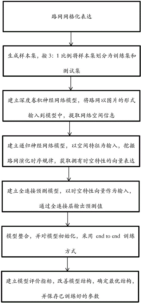
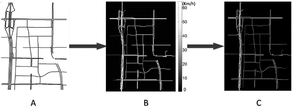
[0056] Step 1: Establish a sample set, divide the training set and test set, and select a road network such as figure 1 As shown in A, the road network is divided into various small road sections, including 278 road sections in total, and each road section is numbered, recorded as (1,2,3,...,278), and 24 hours a day is divided into each time length. Time period (every 2 minutes as a time period).

[0057] First, calculate the average speed of each road segment at each time per...


PUM


Abstract

The invention discloses a road network state prediction method based on a depth space-time convolution circulation network. The method comprises steps of step 1, establishing a sample set and dividing a training set and a test set; step 2, modeling a road network state prediction model, wherein the road network state prediction module comprises a convolution neural network and a recurrent neural network, the convolution neural network is used for extracting space features of the road network and the recurrent neural network is used for extracting sequential rules of the evolution of the road network; and step 3, carrying out road network state prediction in a certain period in the future. According to the invention, through the depth convolution neural network, relations between sections in the road network are extracted; through the recurrent neural network, the sequential rules of the revolution of the road network are extracted; and quite precise prediction of road network traffic states can be obtained by fully considering the space-time information of the road network.

Description

technical field [0001] The invention relates to the technical field of public transportation information processing, in particular to a road network state prediction method based on a deep spatio-temporal convolutional loop network. Background technique [0002] The rapid development of the economy has greatly increased people's demand for transportation, and the problem of traffic congestion has become increasingly prominent. Intelligent transportation system is considered to be an important way to alleviate traffic congestion, and predicting traffic congestion from the network level is of great significance to intelligent transportation system. [0003] In the research of road traffic, it usually includes the difference between road section and road network. Road section usually refers to a certain section of road, while road network refers to a network traffic system formed by interlacing multiple roads in a certain predetermined area. [0004] Most of the road congestio...

Claims


Application Information

Patent Timeline
Patent Type & Authority Applications(China)
IPC IPC(8): G08G1/01G06N3/04
Inventor 于海洋吴志海杨刚马晓磊杨帅
Owner BEIHANG UNIV
Learn More