Surface cover surface area raster calculation method and device

A technology of surface coverage and calculation methods, applied in the field of geospatial information, can solve problems such as unsatisfactory, high complexity of calculation methods, difficult large-scale parallel calculations, etc., and achieve the effect of low efficiency and reduced calculation amount

Active Publication Date: 2017-10-10
NAT GEOMATICS CENT OF CHINA
View PDF7 Cites 4 Cited by
  • Summary
  • Abstract
  • Description
  • Claims
  • Application Information

AI Technical Summary

Problems solved by technology

[0003] The calculation method of the traditional statistical method of land cover surface area is high in complexity. Using traditional serial calculation logic, it is difficult to achieve large-scale parallel calculation, and the overall calculation efficiency is low. It does not meet the reality of large-scale and high-performance statistics of land cover surface area in the era of big data. need

Method used


Image

  • Surface cover surface area raster calculation method and device
  • Surface cover surface area raster calculation method and device
  • Surface cover surface area raster calculation method and device

Examples


Embodiment Construction

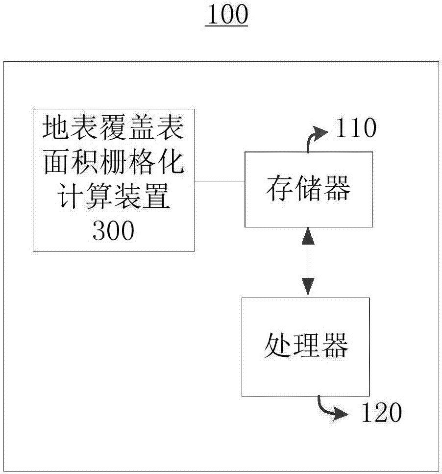
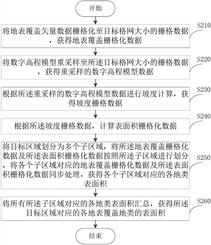
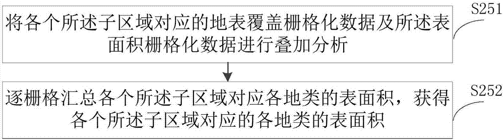
[0023] The following will clearly and completely describe the technical solutions in the embodiments of the present invention with reference to the accompanying drawings in the embodiments of the present invention. Obviously, the described embodiments are only some, not all, embodiments of the present invention. The components of the embodiments of the invention generally described and illustrated in the figures herein may be arranged and designed in a variety of different configurations. Accordingly, the following detailed description of the embodiments of the invention provided in the accompanying drawings is not intended to limit the scope of the claimed invention, but merely represents selected embodiments of the invention. Based on the embodiments of the present invention, all other embodiments obtained by those skilled in the art without making creative efforts belong to the protection scope of the present invention.

[0024] It should be noted that like numerals and let...


PUM


Abstract

The embodiment of the invention provides a surface cover surface area raster calculation method and device. The method comprises the steps of rasterizing surface cover vector data to raster data of which the size is the same with that of a target grid; resampling a digital elevation model to the raster data of which the size is the same with that of the target grid; according to resampled digital elevation model data, carrying out slope calculation; calculating surface area raster data; dividing a target area into multiple subareas, synchronously processing surface cover raster data and surface area raster data corresponding to all the subareas, and obtaining all land type surface area corresponding to all the subareas; summarizing all the land type surface area corresponding to all the subareas, and obtaining all surface cover land type surface area corresponding to the target area. The surface cover surface area raster calculation method significantly reduces calculation amount of surface area, lightweight and parallel calculation of the surface cover surface area is achieved, and technical problems of effective and dynamic surface area calculation of the mass timing sequence surface cover data in the big data age can be addressed.

Description

technical field [0001] The invention relates to the field of geospatial information, in particular to a method and device for calculating the gridded surface area of ​​the earth surface. Background technique [0002] With the advent of the era of big data in smart cities, earth observation, satellite remote sensing, ecological assessment, and land supervision are gradually developing in the direction of macro, dynamic, and refined. great potential demand. [0003] The calculation method of the traditional statistical method of land cover surface area is high in complexity. Using traditional serial calculation logic, it is difficult to achieve large-scale parallel calculation, and the overall calculation efficiency is low. It does not meet the reality of large-scale and high-performance statistics of land cover surface area in the era of big data. need. Contents of the invention [0004] In view of this, the purpose of the embodiments of the present invention is to provid...

Claims


Application Information

Patent Timeline
Patent Type & Authority Applications(China)
IPC IPC(8): G06F19/00
CPCG16Z99/00
Inventor 高崟周旭王发良
Owner NAT GEOMATICS CENT OF CHINA
Why Eureka
Try Eureka