High-precision map and sensor fusion based location method of ramp of underground parking garage

An underground parking lot and positioning method technology, applied in the field of automatic driving, can solve the problems of unsuitable indoor ramp vehicle positioning, unsuitable wireless network indoor positioning technology, etc., and achieve good working condition adaptability and accuracy, good The effect of low scalability, design cost, and maintenance cost

CN107270915AInactive Publication Date: 2017-10-20JIANGSU UNIV
4 Cites 20 Cited by

Patent Information

Authority / Receiving Office
CN · China
Patent Type
Applications(China)
Current Assignee / Owner
Publication Date
2017-10-20
Estimated Expiration
Not applicable · inactive patent

Smart Images

  • Figure 1
    Figure 1
  • Figure 2
    Figure 2
Patent Text Reader

Abstract

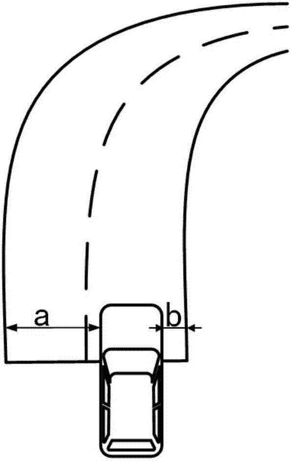
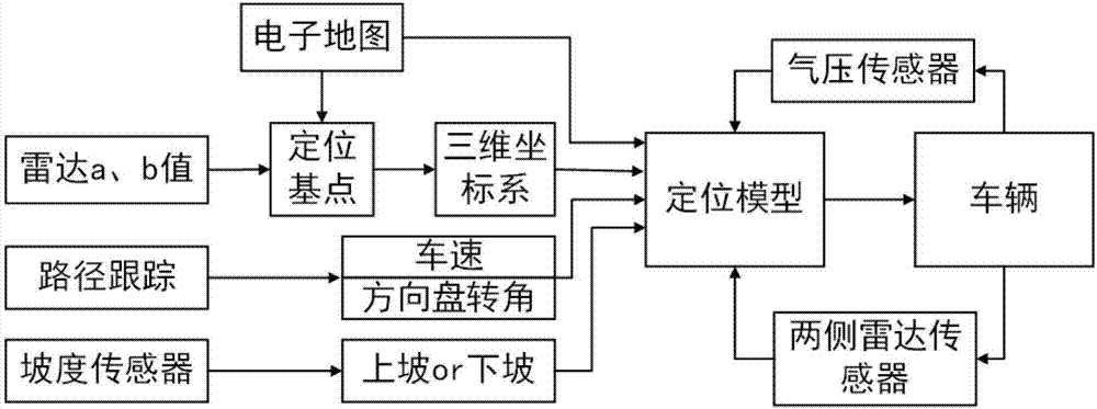
The invention discloses a high-precision map and sensor fusion based location method of a ramp of an underground parking garage. The location method comprises the following steps of a step 1), when an autonomous vehicle is enabled to begins entering the ramp of the underground parking garage, apperceiving the type of the ramp by an in-vehicle gradient sensor, so as to obtain the information that the vehicle is enabled to begins entering the ramp of the underground parking garage; a step 2), when the autonomous vehicle is enabled to begins entering the ramp, measuring distances of the vehicle to two walls by radar sensors on two sides of the vehicle, judging the starting point, at the ramp, of the vehicle in a matching manner by the distances and the high-precision map in a matching manner, and establishing a three-dimensional coordinate system in the matching manner according to the relative position, , at the ramp, of the starting point and the high-precision map in the matching manner; a step 3), subjecting a known path to digital curving to obtain the formula of the known path, and correspondingly moving transferring into the three-dimensional coordinate system; a step 4), after the autonomous vehicle is enabled to enters the ramp, calculating the running mileage of the vehicle through a wheel speed pulse signal output value, matching the mileage with the formula of the path subjected to the curving to obtain the point coordinates of a corresponding curve length, namely the location coordinates of the vehicle in the coordinate system at the moment, of a corresponding curve length.
Need to check novelty before this filing date? Find Prior Art

Description

technical field

[0001] The invention belongs to the field of automatic driving, and in particular relates to a ramp positioning method of an underground parking lot based on high-precision maps and sensor fusion. Background technique

[0002] With the continuous promotion of semi-automatic parking technology, more and more researches have begun to focus on fully automatic parking and autonomous parking. Bosch demonstrated its fully automatic parking technology based on the Mercedes-Benz B180 at the 2016 China Automobile Annual Conference. BMW demonstrated a remote valet parking system at CES 2015. Drivers only need to drive the vehicle to the entrance of the parking lot to activate the remote valet parking system through a smart watch. Audi demonstrated one-button automatic parking in the parking lot at CES 2013, using laser scanners in the parking lot for vehicle positioning.

[0003] With the rapid increase of urban cars and the continuous compression of urban parking sp...

Examples

Embodiment Construction

[0017] The present invention will be further described below in conjunction with accompanying drawings and specific examples. It should be pointed out that the technical solution and design principles of the present invention are only described below with an optimized technical solution, but the protection scope of the present invention is not limited thereto.

[0018] An underground parking lot ramp positioning method based on high-precision map and sensor fusion of the present invention is to match the value measured by the radar sensors on both sides of the vehicle with the width of the ramp entrance in the high-precision map to construct a three-dimensional positioning coordinate system ; Calculate the mileage value of the vehicle from the wheel speed pulse signal, compare the mileage value with the arc length value of the driving path curve, and calculate the positioning coordinates; improve the universal applicability of the indoor positioning method.

[0019] figure 1 I...