A method for planning a local path of a water surface unmanned ship

A technology for local path planning and unmanned boats, applied in computer parts, image data processing, instruments, etc., to achieve excellent recognition rate and detection speed, and achieve the effect of smooth segmentation and summation

Active Publication Date: 2019-06-21
SOUTH CHINA UNIV OF TECH
View PDF5 Cites 9 Cited by
  • Summary
  • Abstract
  • Description
  • Claims
  • Application Information

AI Technical Summary

Problems solved by technology

The invention aims at the local obstacle avoidance problem of the surface unmanned vehicle under complex sea conditions, introduces machine vision and deep learning principles to process visual information so as to realize water surface boundary line detection and water surface obstacle identification, and constructs a water surface unmanned vehicle environment model, and uses this Based on calling the local path planning algorithm of the surface unmanned vehicle, the effective obstacle avoidance direction of the surface unmanned vehicle is calculated in real time, so as to realize the local obstacle avoidance of the surface unmanned vehicle in unknown waters

Method used


Image

  • A method for planning a local path of a water surface unmanned ship
  • A method for planning a local path of a water surface unmanned ship
  • A method for planning a local path of a water surface unmanned ship

Examples


Embodiment Construction

[0053] The present invention will be further described in detail below in conjunction with the embodiments and the accompanying drawings, but the embodiments of the present invention are not limited thereto.

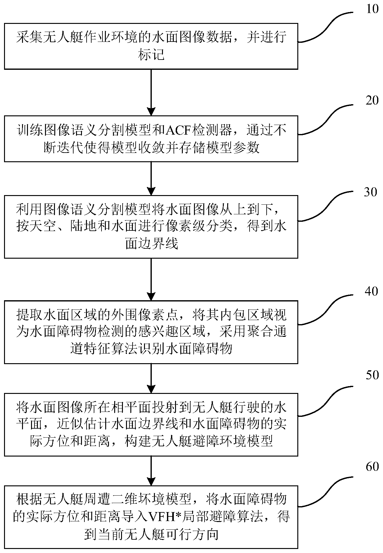
[0054] A local path planning method for surface unmanned boats, such as figure 1 shown, including the following steps:

[0055] The first step is to collect and mark the water surface image data of the operating environment of the unmanned boat; specifically: the water surface image captured by the boat-mounted network camera is obtained through the RTSP video stream protocol, and the semantic segmentation model training set divides the water surface image at the pixel level From top to bottom, it is marked as sky, land and water. Each pixel is marked as a category, while the ACF detector training set uses a rectangular frame to select water surface obstacles. The marked data is [x, y, width, height], which respectively represent the pixel abscissa and pixel ordinate of...


PUM


Abstract

The invention discloses a method for planning a local path of a water surface unmanned ship. The method comprises the following steps: acquiring water surface image data of an unmanned ship operationenvironment and marking the water surface image data; Training an image semantic segmentation model and an ACF detector, and enabling the model to converge and store model parameters through continuous iteration; Performing pixel-level classification on the water surface image by using an image semantic segmentation model to obtain a water surface boundary line; Extracting an area where a water surface obstacle exists, and identifying the water surface obstacle by adopting an aggregation channel characteristic algorithm; Projecting the phase plane where the water surface image is located to the driving horizontal plane of the unmanned ship, estimating the water surface boundary line and the actual direction and distance of a water surface obstacle, and constructing an obstacle avoidance environment model of the unmanned ship; Importing the water surface obstacle data into a VFH * local obstacle avoidance algorithm to obtain a current feasible direction of the unmanned ship; According to the invention, the obstacle is subjected to feature recognition, effective extraction of water surface image information is realized, a reasonable local path planning strategy is obtained, and the obstacle avoidance requirement of the unmanned ship is met.

Description

technical field [0001] The invention relates to the technical field of intelligent control of unmanned boats, in particular to a local path planning method for unmanned boats on water surfaces. Background technique [0002] Unmanned vehicle is a complex system, and its research content involves many aspects, and it has different functional goals according to different work needs. However, regardless of the needs of the unmanned boat, its main functional goals should include the ability to realize unmanned automatic navigation and automatic obstacle avoidance, that is, to embody "unmanned" and "intelligence", which is the most basic Characteristics. Among them, unmanned obstacle avoidance technology, as one of the core technologies of unmanned boats, is not only a standard for measuring the intelligence level of unmanned boats, but also the key to safe navigation of unmanned boats in complex sea areas. [0003] At present, the local path planning methods in the field of unm...

Claims


Application Information

Patent Timeline
Patent Type & Authority Applications(China)
IPC IPC(8): G06K9/00G06K9/34G06K9/62G06T5/30G06T5/40G06T7/62
CPCY02A90/30
Inventor 洪晓斌魏新勇
Owner SOUTH CHINA UNIV OF TECH
Why Eureka
Try Eureka