A Multi-scale Residential Place Matching Method Oriented to Spatial Division

A technology of spatial division and matching method, applied in the field of matching between multi-map elements, it can solve the problems of weakening the scale effect, uncertainty, similarity assessment of the overall graphics of the residential area, etc., to achieve the effect of maintaining the breadth and accuracy

Active Publication Date: 2019-10-18
CHINA UNIV OF GEOSCIENCES (WUHAN)
View PDF2 Cites 0 Cited by
  • Summary
  • Abstract
  • Description
  • Claims
  • Application Information

AI Technical Summary

Problems solved by technology

[0003] The description of the multi-scale features of a single entity with the same name refers to the calculation of the similarity of the geometry and other features of the entity with the same name at different scales; this method does not evaluate the similarity of the overall graphic of the residential area, but only considers the scale change and divides the whole into several parts for processing , to weaken the scale effect, and obtain as much similarity as possible between entities with the same name at different scales, but for multi-scale residential matching, there are fewer 1:1 matching types; a single residential entity pairing cannot build a global map between maps , and without any location constraints, it is difficult to find entities with corresponding relationships at multiple scales
[0004] Constructing relative location constraints such as roads or regular grids narrows the range of candidate matching sets to a certain extent; in addition, the road attribute information is rich, and the constraint process is simple and efficient; however, the road coverage area is small, so there is a large gap in the constraint range limitations, and at multiple scales, the granularity of constraints is also unequal. For example, the display of roads on a larger scale map is denser and the constraints are more refined; the method of using unnatural elements such as grids to add constraints to the map space, Then there are problems such as the selection of the grid size. The starting point of the grid from the map construction and the spacing between the grid lines will affect the effect of spatial constraints. This method has great uncertainty and often divides residents. Ground entity
[0005] Add adjacent objects, combine discrete residential entities, and replace single entities to form a new residential similarity evaluation unit; entities with the same name have different forms on maps of different scales, so the evaluation of the similarity of a single entity with the same name is not enough to determine matching relationship; this method makes up for this deficiency to a certain extent; but the selection of this adjacent object does not take into account the inconsistency of the importance of the neighboring elements, and the consequence of this is that the similarity value is mixed with a lot of noise; in the evaluation combination Before the similarity of the new entity after the new entity, its combination elements are already unequal, the essential reason is that there is no relative position constraint

Method used


Image

  • A Multi-scale Residential Place Matching Method Oriented to Spatial Division
  • A Multi-scale Residential Place Matching Method Oriented to Spatial Division
  • A Multi-scale Residential Place Matching Method Oriented to Spatial Division

Examples


Embodiment Construction

[0026] In order to make the purpose, technical solution and advantages of the present invention clearer, the embodiments of the present invention will be further described below in conjunction with the accompanying drawings.

[0027] Please refer to figure 1 , an embodiment of the present invention provides a spatial subdivision-oriented multi-scale settlement matching method for updating and integrating settlements between maps of different scales, including the following steps:

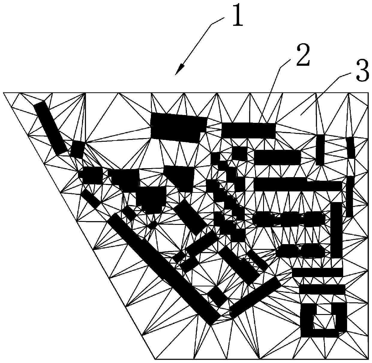
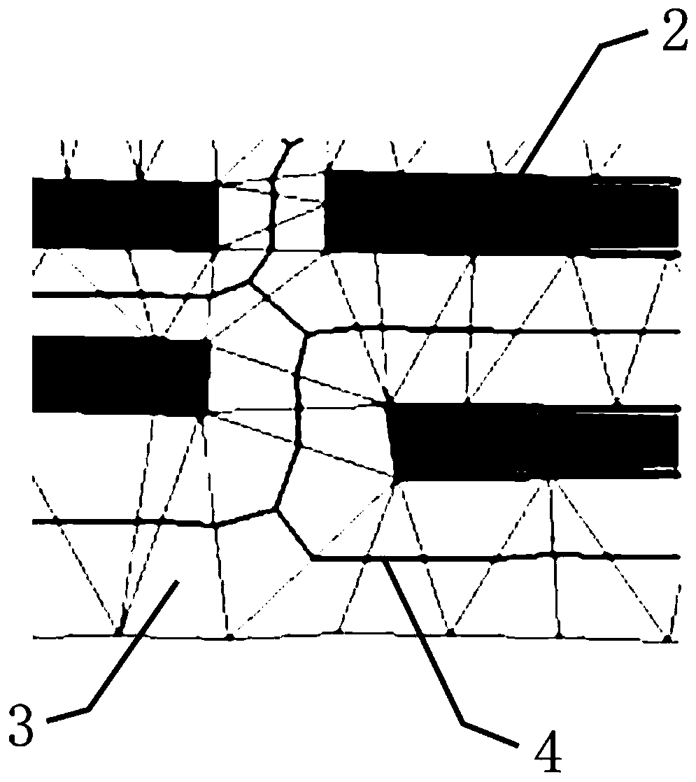
[0028] Please refer to figure 2 and image 3 , Step 1: Select the main road network of the map to be matched, divide the space of the map to be matched into several closed blocks, that is, the road mesh, and use the attribute information of the main road to match the road mesh of the small-scale map and the large-scale map; after matching Under the road mesh of , encrypt the nodes of the residential area 2 in the road mesh 1 with a smaller scale, and then build a Delaunay triangular network 3 bas...


PUM


Abstract

The invention provides a multiple dimensioned residential area matching method facing space division; the method comprises the following steps: selecting a to-be matched map trunk road network, segmenting the to-be matched map space into a plurality of road network meshes, and matching the road network meshes between different scales; building blank area frame lines under the matched road network meshes, and dividing the road network meshes into groups and blank area frame line network meshes; dividing space of each road network mesh of the small scale map according to same steps; building blank area frame line network meshes of the large scale map, and extracting residential area groups in each road network mesh; matching the residential area groups, blank area frame line meshes and residential area entities in different scale maps grade by grade, thus finally obtaining the mapping system using the blank area frame line network meshes as units between different scale maps; the multi-grade space division and progressive matching method can enhance the entity matching accuracy and credibility between residential areas of different scales.

Description

technical field [0001] The invention relates to the technical field of matching between multiple map elements, in particular to a multi-scale residential area matching method oriented to spatial subdivision. Background technique [0002] At present, for the update and integration between different databases, the matching technology of entities with the same name is mainly concentrated on the same or similar scales, and there are few studies on multi-scale. Residential areas account for a large proportion of the urban map space. The key elements of data update, the matching methods of multi-scale residential areas mainly include: (1) description of multi-scale features of a single entity with the same name; (2) constructing relative position constraints such as roads or regular grids, and narrowing down the matching candidate set; (4) ) to join adjacent objects, to expand the entity with the same name by means of buffer combination, that is, to use the newly combined entity w...

Claims


Application Information

Patent Timeline
Patent Type & Authority Patents(China)
IPC IPC(8): G06T7/32
Inventor 叶亚琴万波周顺平莫叶安左泽均胡茂胜
Owner CHINA UNIV OF GEOSCIENCES (WUHAN)
Why Eureka
Try Eureka