Road traffic jam analysis method based on aerial image

A technology of aerial imagery and analysis method, which is applied in the field of intelligent transportation, and can solve the problem of low intelligence of the congestion analysis model

Inactive Publication Date: 2017-10-27
NANJING UNIV OF AERONAUTICS & ASTRONAUTICS
View PDF15 Cites 26 Cited by
  • Summary
  • Abstract
  • Description
  • Claims
  • Application Information

AI Technical Summary

Problems solved by technology

[0004] The technical problem to be solved by the present invention is to propose a road traffic congestion analysis method based on aerial images by using unmanned aerial vehicles combined with image processing technology in view of the shortcomings of existing traffic information collection equipment and the low intelligence of the congestion anal

Method used


Image

  • Road traffic jam analysis method based on aerial image
  • Road traffic jam analysis method based on aerial image
  • Road traffic jam analysis method based on aerial image

Examples


Embodiment Construction

[0112] Below in conjunction with accompanying drawing, technical scheme of the present invention is described in further detail:

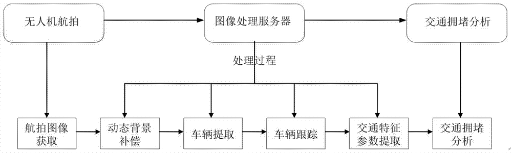
[0113] figure 1 Shown is a schematic flow chart of the road traffic congestion analysis method based on aerial images. Generally speaking, the entire detection method includes the following processes:

[0114] Step 1: Aerial Image Acquisition

[0115] Aerial images are collected by drones flying slowly over the road or hovering over the road with a rotating camera, and then transmitted to a remote server through a wireless network for storage.

[0116] Step 2: Dynamic Background Compensation

[0117] The first frame is selected as the reference frame, and a frame in the subsequent frames is the frame to be compensated, and the Harris algorithm is used to extract the corner points of the reference frame and the frame to be compensated, and then the template matching method is used to extract the corner points of the reference frame and the frame t...


PUM


Abstract

The invention provides a road traffic jam analysis method based on an aerial image. The method comprises the following steps that: firstly, through an unmanned aerial vehicle, collecting to obtain the aerial image, and transmitting the aerial image to a remote server to be stored; secondly, aiming at the aerial image of a dynamic background to introduce a background compensation technology, reconstructing a static scene in a period of time, adopting a pixel gray level based voting strategy to finish background extraction on the basis, and therefore, utilizing a background subtraction and morphological erosion technology to extract road vehicles; then, adopting an improved mean value drift tracking algorithm to finish the tracking of all vehicles; and finally, combining with a frame rate to calculate time occupancy and average travel speed, taking the time occupancy and the average travel speed as basic indexes for a jam analysis model, establishing a model based on a fuzzy theory, and realizing traffic jam analysis. By use of the method disclosed by the invention, data support can be provided for transport agencies to further carry out traffic jam analysis and a jam dredging strategy, so that a traffic jam phenomenon can be avoided as far as possible, and road traffic resources can be reasonably used to a maximum degree.

Description

technical field [0001] The invention relates to the field of intelligent transportation, in particular to a method for analyzing road traffic jams based on aerial images. Background technique [0002] With the rapid development of the economy, people's living standards are generally improved, and the way of traveling by car instead of walking is becoming more and more popular. However, urban road construction cannot keep up with the pace of car popularization, and the road traffic situation is deteriorating, which not only affects The traffic problem in the whole city also seriously affects the safety of people's life and property. Traffic intelligence is the most effective and important measure to solve today's traffic problems. The development of intelligent transportation technology can not only effectively improve the efficiency of vehicle operation, but also relieve driver fatigue, which is an important way to reduce traffic accidents. [0003] Urban road traffic cong...

Claims


Application Information

Patent Timeline
IPC IPC(8): G06K9/00G06K9/62G06K9/46G08G1/017
CPCG08G1/017G06V20/176G06V10/40G06V10/751G06F18/241
Inventor 黎宁蒋振业陈成徐斌徐智
Owner NANJING UNIV OF AERONAUTICS & ASTRONAUTICS
Why Eureka
Try Eureka