Positioning method and position system of satellite navigation system and ground receiving system

A technology of a satellite navigation system and a positioning method, which is applied in the field of the positioning method and system of the satellite navigation system and the ground receiving system, can solve the problems of low positioning accuracy, and achieves a wide range of applications, reducing the difficulty of solving, and improving the positioning accuracy. Effect

Active Publication Date: 2017-11-07
GUANGZHOU HAIGE COMM GRP INC
View PDF3 Cites 20 Cited by
  • Summary
  • Abstract
  • Description
  • Claims
  • Application Information

AI Technical Summary

Problems solved by technology

[0004] Based on this, it is necessary to provide a satellite navigation system positioning method and system and a ground receiving system for the problem of low positioning accuracy

Method used


Image

  • Positioning method and position system of satellite navigation system and ground receiving system
  • Positioning method and position system of satellite navigation system and ground receiving system
  • Positioning method and position system of satellite navigation system and ground receiving system

Examples


Embodiment Construction

[0028] The technical solution of the present invention will be described below in conjunction with the accompanying drawings.

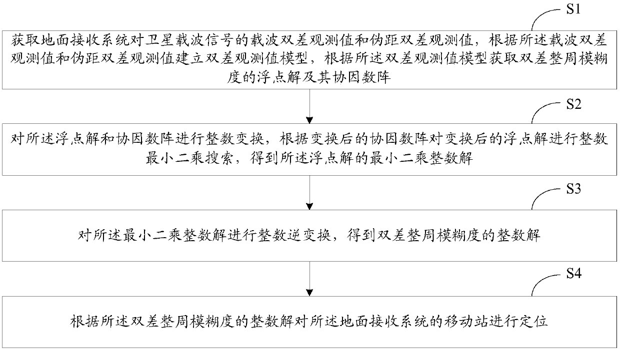
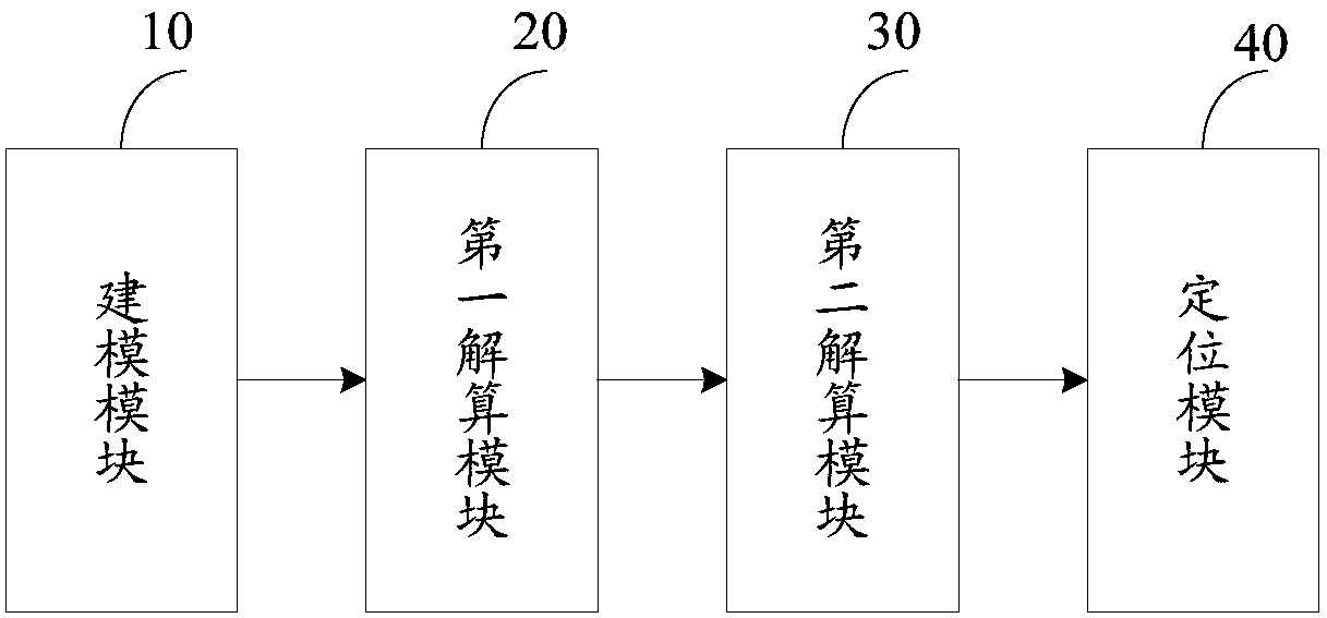
[0029] Such as figure 2 As shown, the present invention provides a positioning method for a satellite navigation system, which may include the following steps:

[0030] S1. Obtain the carrier double-difference observation value and the pseudo-range double-difference observation value of the satellite carrier signal by the ground receiving system, establish a double-difference observation value model according to the carrier double-difference observation value and pseudo-range double-difference observation value, and according to the double-difference observation value The floating-point solution of the double-difference integer ambiguity and its cofactor matrix are obtained by the difference observation value model;

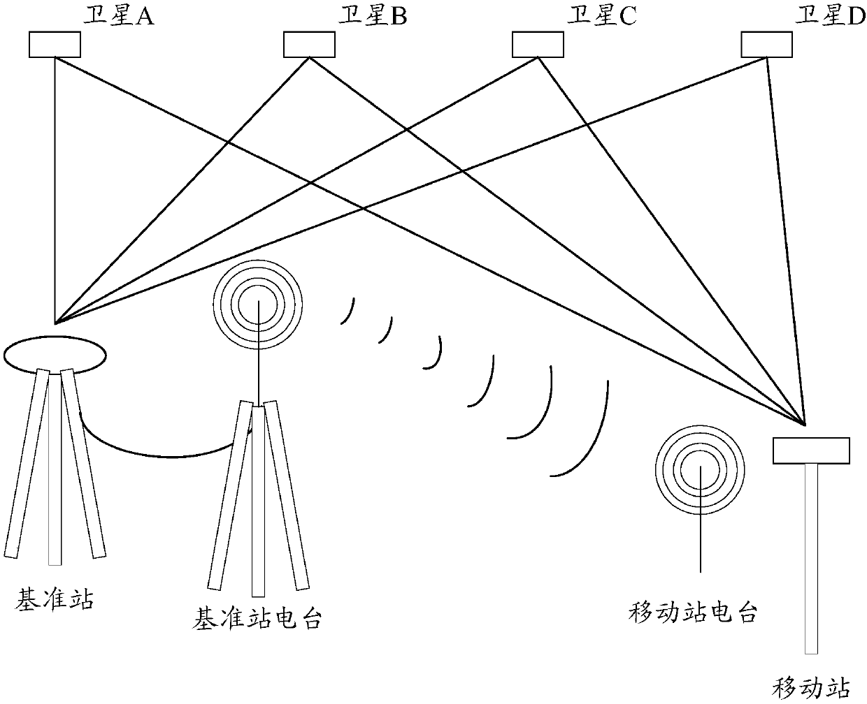
[0031] The satellite navigation system of this embodiment may include a ground receiving system and a plurality of satellites, and th...


PUM


Abstract

The invention relates to a positioning method and a positioning system of a satellite navigation system and a ground receiving system. The positioning method comprises steps that the ground receiving system is used to acquire a carrier double-difference observation value and a pseudo range double-difference observation value of a satellite carrier signal, and a double-difference observation value model is established according to the carrier double-difference observation value and the pseudo range double-range observation value, and float solution of double-difference integer ambiguity and a coordinated factor matrix thereof are acquired; the integer transformation of the float solution and the coordinated factor matrix is carried out, and according to the transformed coordinated factor matrix, the integer least square search of the transformed float solution is carried out to acquire the least square integer solution of the float solution; the integer inverse transformation of the least square integer solution is carried out to acquire the integer solution of the double-difference integer ambiguity; according to the integer solution of the double-difference integer ambiguity, the mobile station of the ground receiving system is located.

Description

technical field [0001] The invention relates to the technical field of satellite navigation, in particular to a positioning method and system of a satellite navigation system and a ground receiving system. Background technique [0002] The satellite navigation system can provide users with high-precision, all-weather navigation, positioning and timing services, and is an indispensable and important space infrastructure. Under the requirement of real-time and high precision, satellite navigation and positioning technology has continuously introduced new technologies, and two technologies, real-time PPP (Point to Point Protocol, point-to-point communication protocol) and RTK (Real Time Kinematic, real-time differential positioning), have emerged. Real-time PPP is to use real-time precise orbit and clock difference products to achieve precise point positioning, but there are many factors that affect the accuracy of real-time precise point positioning, mainly including satellite...

Claims


Application Information

Patent Timeline
Patent Type & Authority Applications(China)
IPC IPC(8): G01S19/04G01S19/44
CPCG01S19/04G01S19/44
Inventor 孙宾姿
Owner GUANGZHOU HAIGE COMM GRP INC
Why Eureka
Try Eureka