Grid method-based dynamic coordinate conversion method for network map service

A technology of network map and dynamic coordinates, applied in the field of geographic information system, to achieve the effect of ensuring accuracy and confidentiality, ensuring reliability, and ensuring richness

Active Publication Date: 2017-11-24
自然资源部海南基础地理信息中心
View PDF9 Cites 23 Cited by
  • Summary
  • Abstract
  • Description
  • Claims
  • Application Information

AI Technical Summary

Problems solved by technology

However, for coordinate systems such as Hainan Plane, Hainan Haikou Independent, Hainan Baisha Independent, Hainan Wenchang Independent, Hainan Yangpu Independent, etc., the coordinate system parameters are confidential data, and users cannot realize the above coordinate systems through the existing coordinate system dynamic conversion method Online real-time coordinate conversion with other coordinate system web map services

Method used


Image

  • Grid method-based dynamic coordinate conversion method for network map service
  • Grid method-based dynamic coordinate conversion method for network map service
  • Grid method-based dynamic coordinate conversion method for network map service

Examples


Embodiment 1

[0053] Haikou City, Hainan Province was selected as the test area, and the accuracy and efficiency of the method of the present invention were verified through the case of realizing the online real-time conversion of the CGCS2000 coordinate system tile map service into the Hainan plane coordinate system. The specific implementation steps include the construction of the control point grid of the experimental area, the construction of the map service coordinate conversion model, the program realization of the server-side map service tile coordinate conversion and the splicing display of the client.

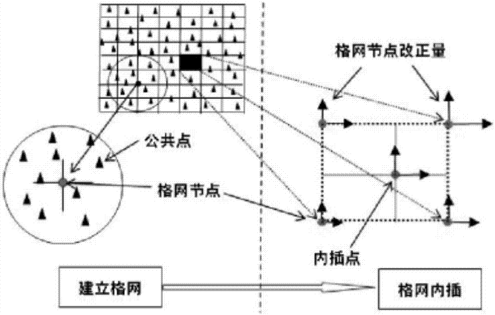
[0054] 1. Build a grid of control points

[0055] According to the basic principle of coordinate transformation of grid method, the construction of control point grid is an important factor affecting the accuracy of coordinate system transformation. There are many kinds of grid construction models, mainly including minimum curvature model, bilinear interpolation model, kriging Inter...

Embodiment 2

[0062] Baisha County, Hainan Province is selected as the test area, and the accuracy and efficiency of the method of the present invention are verified through the case of realizing the online real-time conversion of the CGCS2000 coordinate system tile map service to Hainan Baisha independent coordinate system. The specific implementation steps include the construction of the control point grid of the experimental area, the construction of the map service coordinate conversion model, the program realization of the server-side map service tile coordinate conversion and the splicing display of the client.

[0063] 1. Build a grid of control points

[0064] According to the basic principle of coordinate transformation of grid method, the construction of control point grid is an important factor affecting the accuracy of coordinate system transformation. There are many kinds of grid construction models, mainly including minimum curvature model, bilinear interpolation model, kriging...


PUM


Abstract

The invention discloses a grid method-based dynamic coordinate conversion method for a network map service. The method comprises the following steps of (1) releasing the network map service; (2) establishing a control point grid; (3) obtaining a slice scheme; (4) calculating coordinate affine transformation parameters; (5) calculating a conversion range; (6) establishing a coordinate system conversion database; (7) releasing a coordinate conversion service; and (8) calling the coordinate conversion service. The method realizes online dynamic conversion from the map service meeting international standard specifications in an object coordinate system to a subject data ontology coordinate system in industry field, and has the characteristics of universality, security, accuracy and the like.

Description

technical field [0001] The invention belongs to the technical field of geographic information systems, and relates to a conversion method between network map services of different coordinate systems, in particular to a method for dynamic coordinate conversion of network map services based on a grid method. Background technique [0002] The emergence of Web Service technology enables different applications and different resources running and stored on different machines to be exchanged and integrated without additional, specialized third-party software or hardware. Therefore, providing spatial data to third parties in the form of services has become the main service method of data providers. At present, OGC has proposed WMS, WFS, WMTS and other network map service specifications in combination with WebService technology, providing a set of standard data access and operation interfaces for network map services, and standardizing the behavior and integration of map service rele...

Claims


Application Information

Patent Timeline
Patent Type & Authority Applications(China)
IPC IPC(8): G06F17/30
CPCG06F16/29
Inventor 韩雪华熊小青高凡黄伟招刘璐马庆荣邢增招
Owner 自然资源部海南基础地理信息中心
Why Eureka
Try Eureka