Supercharge Your Innovation With Domain-Expert AI Agents!

Grid system based on GIS and method for making integrated anomaly resolution map through grid system

A technology of grid system and anomaly graph, which can be used in filling planes with attributes, special data processing applications, instruments, etc., can solve problems such as high professional technical requirements, error prone, lack of scalable systems, etc., to reduce professional technology The effect of requirements, improving drawing efficiency, and simplifying experience in drawing

Active Publication Date: 2017-12-08
CHINA UNIV OF GEOSCIENCES (WUHAN)
View PDF5 Cites 0 Cited by
  • Summary
  • Abstract
  • Description
  • Claims
  • Application Information

AI Technical Summary

Problems solved by technology

[0006] The traditional production method has the following disadvantages: drawing efficiency is low and error-prone: in the drawing process, the offset, color scale position, size and other values ​​of each single-element anomaly map need to be calculated separately, and every link in the analysis map production needs to rely on The software is manually drawn, which takes a long time to draw and is prone to errors; it is not easy to modify after production: Analysis Figure 1 Once the drawing is completed, it will be difficult to modify it again and needs to be re-made; it requires high professional skills: the maker of the analysis drawing needs to have a full understanding of the production specifications of the analysis drawing, and the production method needs training; lack of a unified and scalable system: different There are slight differences in the drawing requirements of the units. At present, there is no unified anatomical drawing system that can meet the drawing needs of different production units.

Method used


Image

  • Grid system based on GIS and method for making integrated anomaly resolution map through grid system
  • Grid system based on GIS and method for making integrated anomaly resolution map through grid system

Examples


Embodiment Construction

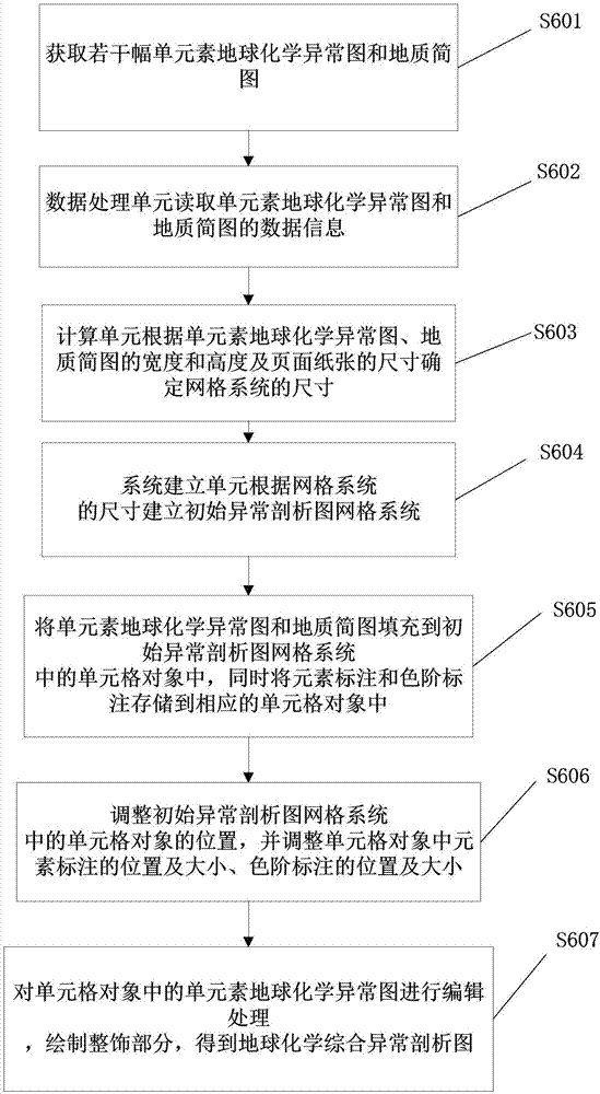
[0031] In order to make the purpose, technical solution and advantages of the present invention clearer, the embodiments of the present invention will be further described below in conjunction with the accompanying drawings.

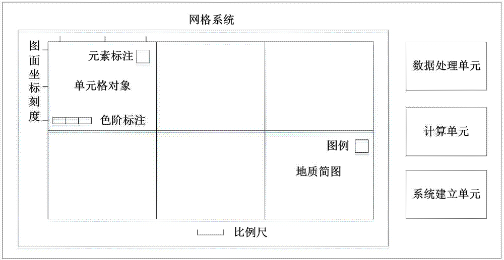
[0032] Please refer to figure 1 , the embodiment of the present invention provides a GIS-based grid system, which includes several cell objects, a data processing unit, a calculation unit and a system establishment unit.

[0033] The cell object is used to fill the single-element geochemical anomaly map and the simplified geological map. Each cell object contains the element label of the geochemical element and the size, position and color scale label of the geochemical element, as well as the size and position of the color scale label. The position of the element label and the position of the color scale label include orientation and offset. The orientation refers to the drawing position of the element label and the color scale label relative to the ce...


PUM


Abstract

The invention provides a grid system based on a GIS. The grid system comprises several cell objects, a data processing unit, a calculating unit and a system establishing unit. The invention also provides a method for making an integrated anomaly resolution map through the grid system. The method comprises steps of obtaining several single element geochemical anomaly maps and geological sketches; reading data information of the single element geochemical anomaly maps and the geological sketches by the data processing unit; determining the dimension of the grid system according to the data information and the dimension of page paper by the calculating unit; establishing an initial anomaly resolution map grid system according to the dimension of the grid system by the system establishing unit; populating the single element geochemical anomaly maps and the geological sketches in cell objects in the initial anomaly resolution map grid system; adjusting positions of the cell objects; processing the single element geochemical anomaly maps in the cell objects, drawing a grooming part, and obtaining a geochemical integrated anomaly resolution map. According to the invention, the drawing efficiency of the integrated anomaly resolution map is effectively improved.

Description

technical field [0001] The invention relates to the technical field of computer graphics, in particular to a GIS-based grid system and a method for making a comprehensive anomaly analysis diagram with it. Background technique [0002] After the completion of the geochemical census work, the necessary geochemical maps and materials must be provided to the unit issuing the task. The maps and materials that must be submitted include: geochemical maps of main mineralization and associated elements (simplified geological and mineral maps are attached), Anomaly map (single element or comprehensive element anomaly map), report of geochemical exploration results. The drawings and materials to be submitted according to the needs include: important anomaly anatomy diagram and its description; anomaly list and ranking of important anomalies; mineralization prospect map and relevant description; multivariate analysis diagram and other explanatory and inferential diagrams and Relevant i...

Claims


Application Information

Patent Timeline
Patent Type & Authority Applications(China)
IPC IPC(8): G06F17/30G06T11/40
CPCG06F16/29G06T11/40
Inventor 张剑波赵加奥夏灯城李永昌
Owner CHINA UNIV OF GEOSCIENCES (WUHAN)
Features
  • R&D
  • Intellectual Property
  • Life Sciences
  • Materials
  • Tech Scout
  • Unparalleled Data Quality
  • Higher Quality Content
  • 60% Fewer Hallucinations
Learn More