Method for determining optimal resolution of ocean surface wind field inversion based on SAR (Synthetic Aperture Radar)

A sea surface wind field inversion, optimal resolution technology, applied in the direction of radio wave reflection/re-radiation, use of re-radiation, measurement devices, etc., can solve the problem that the optimal resolution selection method is rarely discussed, etc. The effect of reducing observation difficulty, strong practicability, and simplifying observation equipment

Active Publication Date: 2017-12-22
ZHEJIANG UNIV
View PDF5 Cites 22 Cited by
  • Summary
  • Abstract
  • Description
  • Claims
  • Application Information

AI Technical Summary

Problems solved by technology

[0006] Currently, SAR data are resampled to different spatial resolutions for sea surface wind ...

Method used


Image

  • Method for determining optimal resolution of ocean surface wind field inversion based on SAR (Synthetic Aperture Radar)
  • Method for determining optimal resolution of ocean surface wind field inversion based on SAR (Synthetic Aperture Radar)
  • Method for determining optimal resolution of ocean surface wind field inversion based on SAR (Synthetic Aperture Radar)

Examples


Embodiment Construction

[0034] The present invention will be further described below in conjunction with specific drawings and embodiments.

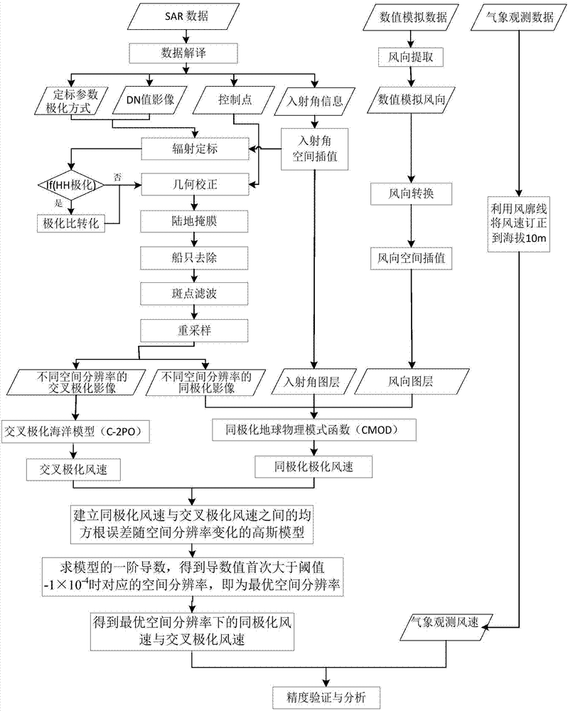
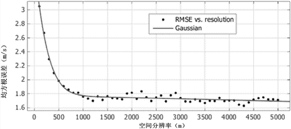
[0035] Such as figure 1 Shown: the present invention is the technical process of automatic determination of the optimal resolution of synthetic aperture radar wind field inversion, and the specific calculation method includes the following steps:

[0036] Step 1. Acquiring SAR images containing both co-polarization and cross-polarization, and preprocessing the acquired images;

[0037] Specifically, to obtain SAR images that include co-polarization and cross-polarization at the same time, at present, many synthetic aperture radars carried by satellites have multi-polarization imaging methods, such as the recently launched Sentinel of the European Space Agency, which can provide a large number of VV+VH Polarized or HH+HV polarized images, where H is the horizontal wave and V is the vertical wave, VV and HH are co-polarized, and VH and HV are cross-polarized. A...


PUM


Abstract

The invention provides a method for determining the optimal resolution of ocean surface wind field inversion based on SAR (Synthetic Aperture Radar), which comprises the steps of acquiring synthetic aperture radar images containing both co-polarization and cross-polarization, and preprocessing the acquired images; performing resampling on co-polarization and cross-polarization backward scattering coefficient images; carrying out ocean surface wind field inversion by using a co-polarization geophysical model function to obtain co-polarized wind field data with different spatial resolutions; carrying out ocean surface wind field inversion by using a cross-polarization ocean model function to obtain cross-polarization wind field data with different spatial resolutions; building a Gaussian model of a root-mean-square error, which changes along with the spatial resolution, of the co-polarization wind field data and the cross-polarization wind field data with different spatial resolutions; and performing first-order derivative derivation on the function, and when the derivative value is greater than -1*10<-4>, regarding the spatial resolution corresponding to the point is the optimal resolution. The wind speed inversed at the spatial resolution is high in accuracy.

Description

technical field [0001] The invention relates to the technical field of synthetic aperture radar data processing, in particular to a method for judging the optimal resolution of sea surface wind field inversion based on synthetic aperture radar (SAR). Background technique [0002] In the past few decades, remote sensing satellite technology has been widely used in the research of ocean observation and regional monitoring. The National Aeronautics and Space Administration (NASA) launched Seasat-1 from Vandenberg on June 27, 1978, with a microwave scatterometer on board. Although the satellite only worked for 105 days, it created a precedent for spaceborne SAR observation of the surface environment, provided us with a large number of images of land, ocean, and ice, obtained unprecedented surface information, and realized all-day Time, all-weather imaging work. The microwave radar carried by the Seasat-1 satellite is L-band, and the obvious stripe features can be interpreted f...

Claims


Application Information

Patent Timeline
IPC IPC(8): G01S13/90G01S13/95
CPCG01S13/9005G01S13/95G01S13/9027G01S13/9076
Inventor 张康宇黄敬峰郭乔影
Owner ZHEJIANG UNIV
Why Eureka
Try Eureka