Online backtracking and comparison method for two-dimensional spatial-temporal geographic information

A geographic information, space-time technology, applied in the field of geographic information, can solve problems such as poor user experience, achieve the effect of avoiding data waiting, promoting the social application of geographic information, and realizing the backtracking function

Pending Publication Date: 2018-01-16
武汉市测绘研究院
View PDF3 Cites 7 Cited by
  • Summary
  • Abstract
  • Description
  • Claims
  • Application Information

AI Technical Summary

Problems solved by technology

As the amount of map service data increases, the above data processing and transmission will cause a long wait when the client performs temporal GIS browsing and backtracking, resulting in poor user experience

Method used


Image

  • Online backtracking and comparison method for two-dimensional spatial-temporal geographic information
  • Online backtracking and comparison method for two-dimensional spatial-temporal geographic information
  • Online backtracking and comparison method for two-dimensional spatial-temporal geographic information

Examples


Embodiment Construction

[0028] The specific implementation manners of the present invention will be further described in detail below in conjunction with the accompanying drawings. Elements and features described in one drawing or one embodiment of the present invention may be combined with elements and features shown in one or more other drawings or embodiments. It should be noted that representation and description of components and processes that are not related to the present invention and known to those of ordinary skill in the art are omitted from the drawings and descriptions for the purpose of clarity.

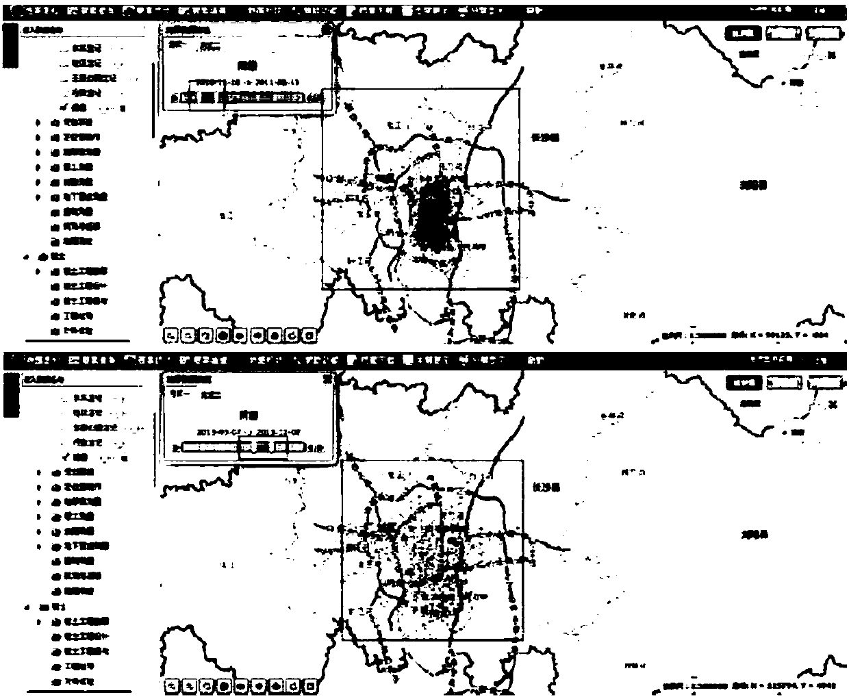
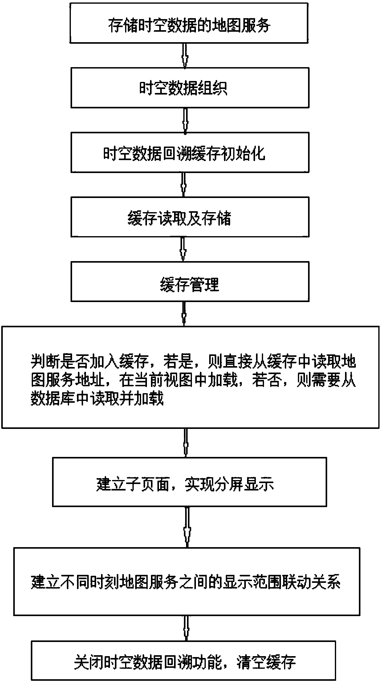
[0029] Such as image 3 As shown, Embodiment 1 of the present invention discloses a method for online backtracking and comparison of two-dimensional spatiotemporal geographic information, which is characterized in that it includes the following implementation steps:

[0030] Step 1, a map service that stores spatio-temporal data. When storing the map service of spatio-temporal data in the d...


PUM


Abstract

The invention belongs to the technical field of geographic information, and provides an online backtracking and comparison method for two-dimensional spatial-temporal geographic information. The method provided by the invention has the advantages that map services can be rapidly read at a web end, so that the function of online efficient backtracking of the two-dimensional spatial-temporal geographic information can be achieved, and the problem of data waiting during display switching among geographic information services at different moments can be avoided; and the function of change comparison among the geographic information services at the different moments and for a same region is achieved, so that the city planning personnel and the land planning personnel can more conveniently analyze city development changes, and social applications of the geographic information can be further promoted.

Description

technical field [0001] The present invention relates to the technical field of geographic information, in particular to an online backtracking and comparison method for two-dimensional spatiotemporal geographic information, which is used in geographic information production and application units, such as planning departments, land departments, surveying and mapping departments, urban design departments, and the like. Background technique [0002] Traditional geographic information system applications only involve two aspects of geographic information: spatial dimension and attribute dimension, so it is also called static GIS (Static GIS). However, in many application fields, space objects change with time, such as environmental detection and measurement of PM2.5 changes in a certain area, distribution of materials in disaster relief areas during earthquake rescue, and statistical analysis of meteorological observation data in various regions during weather forecasting Such t...

Claims


Application Information

Patent Timeline
Patent Type & Authority Applications(China)
IPC IPC(8): G06F17/30
Inventor 郭明武谭仁春孙雅庚
Owner 武汉市测绘研究院
Why Eureka
Try Eureka