A gis-based rapid configuration method for long-distance oil pipelines

A technology for rapid configuration of oil pipelines, applied to measuring devices, instruments, navigation, etc., can solve problems such as slow computer operation, deviation in positioning, and cumbersome configuration, so as to facilitate later operation and maintenance, reduce requirements, and simple method effective effect

Active Publication Date: 2020-11-17
WUHAN WUTOS
View PDF7 Cites 0 Cited by
  • Summary
  • Abstract
  • Description
  • Claims
  • Application Information

AI Technical Summary

Problems solved by technology

However, the configuration of a large number of sensors along the pipeline on the electronic map is very cumbersome and time-consuming, and the positioning will inevitably be biased. Displaying a large number of sensor information points at the same time will take up a lot of resources and slow down the computer.

Method used


Image

  • A gis-based rapid configuration method for long-distance oil pipelines

Examples


Embodiment Construction

[0023] In order to make the objectives, technical solutions and advantages of the present invention clearer, the present invention will be further described in detail below with reference to the accompanying drawings and embodiments. It should be understood that the specific embodiments described herein are only used to explain the present invention, but not to limit the present invention.

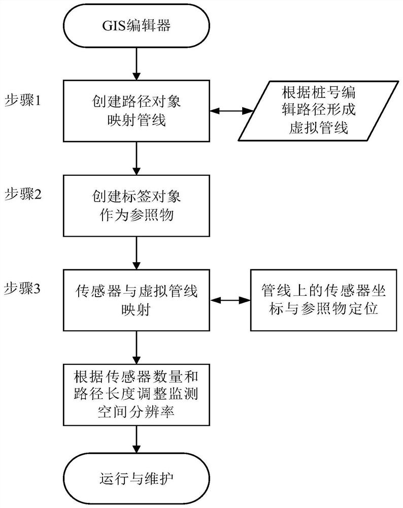
[0024] like figure 1 As shown, the GIS-based rapid configuration method of the long-distance oil pipeline in the embodiment of the present invention is as follows: find the location of the pipeline in the GIS and add control points at the starting point to form a straight line, and correspond to the bending position according to the direction of the pipeline. Add control points on the straight line, drag these control points to change the straight line into a polyline and gradually form a mapped virtual pipeline with the real pipeline. Then add several labels around the virtual pipeline a...


PUM


Abstract

The invention discloses a GIS-based long distance oil pipeline rapid configuration method, which comprises the steps of creating a path object according to a path of an actual oil pipeline in a GIS editor to form a virtual pipeline which is mutually mapped with the actual oil pipeline; creating a plurality of label objects in the vicinity of the virtual pipeline, each label object being a reference object with known latitude and longitude in the vicinity of the virtual pipeline; and mapping sensors onto the virtual pipeline, determining the closest label object to each sensor according to a nearest path principle, and achieving the positioning of each sensor according to the latitude and longitude of the label object. According to the invention, the actual oil pipeline can be monitored without configuring tens of thousands of points on the GIS, the sensors are positioned more accurately, the problem that a large number of sensors in a monitoring system are required to be configured inan electronic map is solved, the system configuration debugging efficiency is allowed to be more than doubled, and at the same time the system post operation and maintenance work is greatly facilitated.

Description

technical field [0001] The invention relates to the technical field of information monitoring, in particular to a GIS-based quick configuration method for long-distance oil pipelines. Background technique [0002] The security warning of long-distance pipelines has always been a regulatory problem, and it is necessary to deploy a large number of sensors along the pipeline to monitor intrusion, theft and other events. In the monitoring software part of pipeline security early warning, because the path function and label function in GIS technology are more convenient for the positioning of sensors, they are widely used. However, the configuration of a large number of sensors along the pipeline on the electronic map is very cumbersome and time-consuming, and the positioning will inevitably be biased. Displaying a large number of sensor information points at the same time will take up a lot of resources and slow down the computer. Contents of the invention [0003] The techni...

Claims


Application Information

Patent Timeline
Patent Type & Authority Patents(China)
IPC IPC(8): G06F16/29G06F30/18G06Q50/06G01C21/00G01C21/34
Inventor 刘简董雷
Owner WUHAN WUTOS
Why Eureka
Try Eureka