Simulation and prediction method of spatial distribution changing pattern of wetland

A technology of spatial distribution and forecasting method, applied in forecasting, instrumentation, data processing applications, etc., can solve the problems of single forecasting scenario, single spatial scale, and low precision, achieve high regional adaptability and improve forecasting accuracy

Inactive Publication Date: 2018-02-06
HANGZHOU NORMAL UNIVERSITY
View PDF2 Cites 10 Cited by
  • Summary
  • Abstract
  • Description
  • Claims
  • Application Information

AI Technical Summary

Problems solved by technology

[0013] The present invention mainly solves the technical problems of single spatial scale, low precision, and single forecast...

Method used


Image

  • Simulation and prediction method of spatial distribution changing pattern of wetland
  • Simulation and prediction method of spatial distribution changing pattern of wetland
  • Simulation and prediction method of spatial distribution changing pattern of wetland

Examples


Embodiment

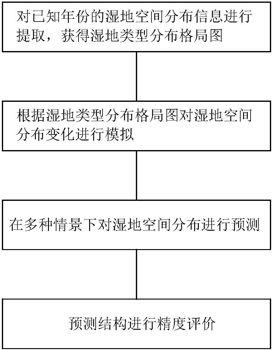
[0054] In this embodiment, a method for simulating and predicting changes in the spatial distribution of wetlands includes the following steps:

[0055] S1. Extract the spatial distribution information of wetlands in known years to obtain the distribution pattern of wetland types; the specific process of information extraction in S1 includes:

[0056] S11. Obtain remote sensing images of the study area for several years, and filter the images according to the preparation coverage and image data; in this embodiment, the remote sensing image data obtained from 1986 to 2016 is taken as an example, and the acquired images are selected according to the vegetation coverage and image quality Screening is performed to remove images with large cloud cover and low vegetation coverage. And select the image data with a period of five years at the same time. The final image data obtained are Landsat series data in 2006, 2011 and 2016.

[0057] S12. Classify wetlands according to their ch...


PUM


Abstract

The invention relates to a simulation and prediction method of a spatial distribution changing pattern of a wetland so that technical problems of single spatial scale, poor precision, and single prediction scene in the prior art can be solved. The method comprises the steps: extracting spatial distribution information of wetlands with known years to obtain a wetland type distribution pattern; according to the wetland type distribution pattern, simulating wetland spatial distribution changes; predicting wetland spatial distribution in various scenes; and carrying out precision evaluation on prediction results. The method has the following advantages: according to the multi-time-space multi-scene wetland distribution pattern simulation and prediction method, prediction on the needed area ofthe wetland is improved by using a CA-Markov model; the simulation and prediction precision of the wetland spatial distribution pattern is enhanced; the regional adaptability is high; and the future spatial distribution pattern simulation and prediction of the wetland can be carried out stably based on a simulation model.

Description

technical field [0001] The invention relates to the technical field of research on temporal and spatial evolution of wetlands, in particular to a method for simulating and predicting changes in spatial distribution of wetlands. Background technique [0002] Existing studies on the spatio-temporal evolution of wetlands mainly focus on the analysis of wetland evolution and landscape pattern, and there is a lack of simulation and prediction research on the spatial distribution pattern of wetlands. The main methods are: [0003] 1. System dynamics; [0004] 2. Markov model; [0005] 3. Cellular automata model; [0006] 4. Multi-agent system. [0007] Early quantitative prediction models focused on qualitatively describing systematic changes in land use, analyzing changes in the number and area of ​​land feature types, and the rate of change. These models are usually mathematical models, which are calculated by computers through fixed mathematical formulas. Results, such as ...

Claims


Application Information

Patent Timeline
IPC IPC(8): G06Q10/04G06Q10/06
CPCG06Q10/04G06Q10/0639
Inventor 胡潭高刘甲红李明张路李瑶吴祎越
Owner HANGZHOU NORMAL UNIVERSITY
Why Eureka
Try Eureka