Unmanned plane set surveying and mapping method based on AGV matrix

A technology of unmanned aerial vehicle and crew, applied in the field of aerial surveying and mapping, can solve the problems of obstacle error, large-scale map surveying and mapping error, etc., and achieve the effect of improving surveying and mapping efficiency and increasing the area of ​​single surveying and mapping.

Active Publication Date: 2018-02-16
SICHUAN COLLEGE OF ARCHITECTURAL TECH
View PDF5 Cites 8 Cited by
  • Summary
  • Abstract
  • Description
  • Claims
  • Application Information

AI Technical Summary

Problems solved by technology

However, UAVs and vehicles only center on one point, so there will inevitably be certain errors in laser mapping of obstacles. At the same time, there are obvious errors in large-scale map mapping.

Method used


Image

  • Unmanned plane set surveying and mapping method based on AGV matrix
  • Unmanned plane set surveying and mapping method based on AGV matrix
  • Unmanned plane set surveying and mapping method based on AGV matrix

Examples


Embodiment 1

[0039] A method for surveying and mapping of unmanned aerial vehicles based on an AGV matrix. The surveying and mapping unmanned aerial vehicle is used as an AGV matrix, and multiple measurements of the surveying and mapping unmanned aerial vehicle are integrated to obtain a surveying and mapping map; the central unmanned aerial vehicle 1 controls the auxiliary unmanned aerial vehicle 2 Carry out multiple surveying and mapping within the set AGV matrix; the central UAV 1 transmits the integrated surveying and mapping data to the remote client through the main controller;

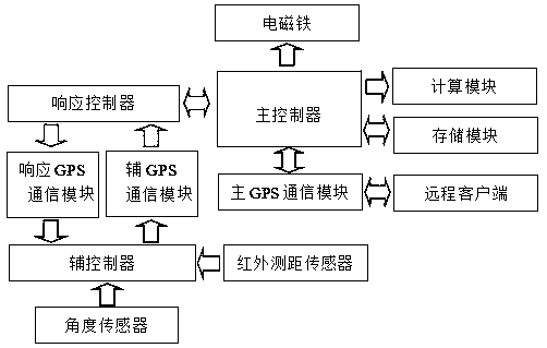
[0040] Such as Figure 4 As shown, the surveying and mapping aircraft group includes a central UAV 1, four auxiliary UAVs 2, and remote clients; the central UAV 1 includes a rack, a main control mechanism, and four corresponding auxiliary UAVs 2 four response control mechanisms provided; the frame of the central UAV 1 extends four flying arms 3 along the four directions of its base, and the free end of the f...

Embodiment 2

[0046] This embodiment is further optimized on the basis of Embodiment 1, and the calculation module sets every 10 centimeters as the turning points. In the present invention, the AGV matrix of the entire measurement range is set as a coordinate system with the center drone 1 as the center point, and then the coordinate system is divided into four coordinate blocks according to the four auxiliary drones 2; Set the turning point every 10 centimeters, and establish a virtual coordinate matrix; the auxiliary UAV 2 defines the landmark values ​​of each group, as well as the rows and columns through the virtual coordinate matrix made by the central UAV 1 and human operations to conduct separate surveying and mapping .

[0047] Other parts of this embodiment are the same as those of Embodiment 1, so details are not repeated here.

Embodiment 3

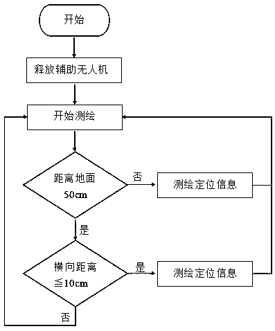
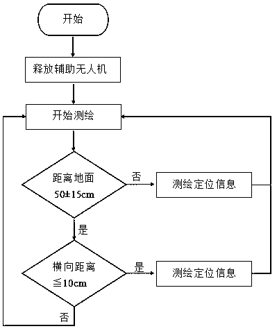
[0049] This embodiment is further optimized on the basis of embodiment 1 or 2, as image 3 As shown, the surveying and mapping is carried out in the surveying and mapping area; when the auxiliary UAV 2 detects through the positioning sensor that the height vertically reaching the ground is not equal to 50±15cm, it indicates that the height of the surveying and mapping area changes, and the auxiliary UAV 2 hovers at The measurement point, and the auxiliary UAV 2 measures the positioning information through the positioning sensor, and measures the distance from the auxiliary UAV 2 to the central UAV 1 and the horizontal angle between the auxiliary UAV 2 and the central UAV 1. The height range from the ground is increased, which effectively removes the interference of ground debris and improves the quality of surveying and mapping.

[0050] Other parts of this embodiment are the same as those of Embodiment 1 or 2 above, so details are not repeated here.


PUM


Abstract

The invention discloses an unmanned plane set surveying and mapping method based on AGV matrix. A surveying and mapping unmanned plane set is mainly an AGV matrix. A central unmanned plane controls anauxiliary unmanned plane to conduct surveying and mapping for many times within a set AGV matrix. The central unmanned plane transmits surveying and mapping data obtained by integration to a remote client through a main controller. Through multimetering integration of the surveying and mapping unmanned plane set, a whole surveying and mapping map is obtained. The whole measurement range AGV matrix is set to be a coordinate system with the central unmanned plane as the central point, and then the coordinate system is divided into four coordinate blocks according to four auxiliary unmanned planes; then, through a calculation module of a main control mechanism, a turning point is arranged every 10 centimeters, and a virtual coordinate matrix is built; and the auxiliary unmanned planes are made into a virtual coordinate matrix through the central unmanned plane and manual operation to define landmark value and row and column of each group for surveying and mapping respectively. By the method of the invention, efficiency of surveying and mapping is effectively enhanced.

Description

technical field [0001] The invention belongs to the technical field of aerial surveying and mapping, and in particular relates to an unmanned aerial vehicle group surveying and mapping method based on an AGV matrix. Background technique [0002] With the rapid development of social intelligence and automation, earth-shaking changes have taken place in various industries, especially the surveying and mapping engineering industry. Now, in addition to some necessary manual surveying and mapping in surveying and mapping engineering, other surveying and mapping steps are gradually converted to drones, vehicles and other instruments carrying three-point laser ranging for surveying and mapping. However, UAVs and vehicles only center on one point, so it is inevitable that there will be certain errors in laser mapping of obstacles. At the same time, there are obvious errors in large-scale map mapping. [0003] With the development of domestic science and technology, the demand for a...

Claims


Application Information

Patent Timeline
Patent Type & Authority Applications(China)
IPC IPC(8): G01C7/00
CPCG01C7/00
Inventor 李孟蔚
Owner SICHUAN COLLEGE OF ARCHITECTURAL TECH
Why Eureka
Try Eureka