Remote sensing surveying and mapping unmanned aerial vehicle with high safety

A safe and unmanned aerial vehicle technology, applied in the field of unmanned aerial vehicles, can solve the problems of safety accidents, small effective range of surveying and mapping, and increased air resistance

Active Publication Date: 2021-09-10
JILIN JIANZHU UNIVERSITY
View PDF18 Cites 3 Cited by
  • Summary
  • Abstract
  • Description
  • Claims
  • Application Information

AI Technical Summary

Problems solved by technology

[0003] According to the flight characteristics, the existing remote sensing mapping UAVs can be divided into two types: fixed-wing UAVs and unmanned helicopters. Fixed-wing UAVs can take off, land and fly through the power system and the sliding of the wings. , strong wind resistance, fast speed, high surveying and mapping efficiency, and long battery life, but the take-off and landing of fixed-wing UAVs requires a relatively open space and taxiing on the runway, and the use scenarios are limited; the technical advantages of unmanned helicopters It is able to take off and land at a fixed point, does not have high requirements on the conditions of the takeoff and landing site, has good maneuverability, has better obstacle avoidance ability, and can be suspended at a fixed point, but its flight speed is slow, the effective range of surveying and mapping is small, and the battery life is short. It is mainly used in investigation of emergencies
[0004] Existing UAVs capable of vertical take-off and landing are prone to hitting obstacles such as personnel, buildings, and branches in low altitudes, and are prone to safety accidents during take-off and landing. Protecting the propeller can improve its safety, but when there are no obstacles when flying at high altitude and high speed, the protective cover becomes a burden instead, increasing air resistance and limiting the flight speed, and the protective cover is also easy to disturb the airflow, which is harmful to drones. operations have an impact on

Method used


Image

  • Remote sensing surveying and mapping unmanned aerial vehicle with high safety
  • Remote sensing surveying and mapping unmanned aerial vehicle with high safety
  • Remote sensing surveying and mapping unmanned aerial vehicle with high safety

Examples


Embodiment Construction

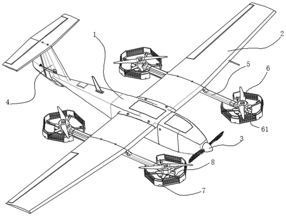
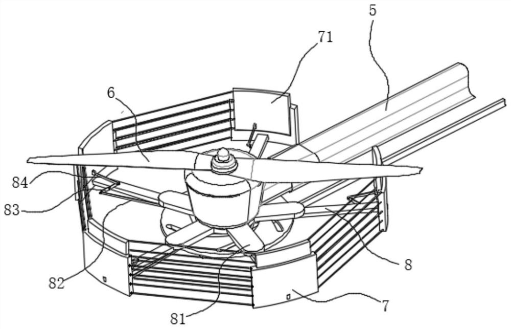
[0042] see figure 1 , in the embodiment of the present invention, a remote sensing surveying and mapping unmanned aerial vehicle with high safety includes a body 1, wings 2 are provided on both sides of the body 1, a front propeller 3 is provided in front, and a tail rudder 4 is provided at the tail; wherein Each of the two wings 2 is symmetrically fixed with a fixed rod 5 parallel to the body 1, the two ends of the fixed rod 5 are rotatably provided with vertical propellers 6, and each of the vertical propellers 6 Each can be driven and rotated by a vertical motor 61 fixed in the fixed rod 5;

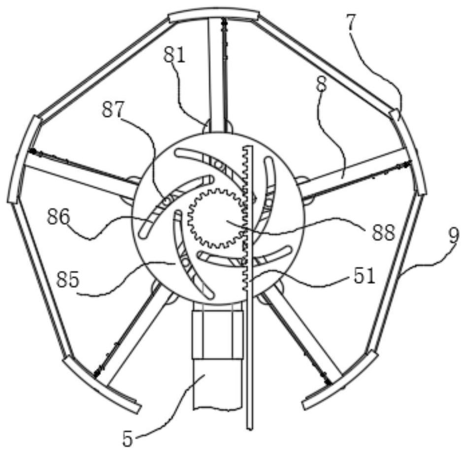
[0043] The bottom of the vertical propeller 6 is distributed along its circumferential direction with a plurality of arc-shaped protective baffles 7, the protective baffles 7 are connected with the fixed rod 5 through the protective bar 8, and the protective bar 8 can adjust the protective baffles 7 and The distance from the center of the vertical propeller 6;

[0044] And, when each...


PUM


Abstract

The invention discloses a remote sensing surveying and mapping unmanned aerial vehicle with high safety, which comprises a vehicle body, wings are arranged on the two sides of the vehicle body, a front propeller is arranged in the front of the vehicle body, and a tail vane is arranged at the tail of the vehicle body; wherein a fixed rod parallel to the aircraft body is symmetrically fixed in each of the two wings, vertical propellers are rotatably arranged at the two ends of each fixed rod, and each vertical propeller can be driven by a vertical motor fixed in the corresponding fixed rod to rotate; a plurality of arc-shaped protection blocking pieces are distributed at the bottom of the vertical propeller in the circumferential direction of the vertical propeller, the protection blocking pieces are connected with the fixing rod through protection rods, and the protection rods can adjust the distance between the protection blocking pieces and the center of the vertical propeller; compared with the prior art, the unmanned aerial vehicle can be in a vertical lifting mode and a fixed wing mode and is good in maneuverability, high in surveying and mapping efficiency and large in activity range. And the protection blocking pieces can be opened and closed, a protection net is formed between the protection blocking pieces and the protection ropes, safety is high when the device is close to the ground, and air resistance is small when the unmanned aerial vehicle is high.

Description

technical field [0001] The invention relates to the technical field of unmanned aerial vehicles, in particular to a highly safe remote sensing surveying and mapping unmanned aerial vehicle. Background technique [0002] Remote sensing surveying and mapping drones use unmanned aerial vehicle technology, remote sensing sensor technology, telemetry and remote control technology, and communication technology to achieve automation, intelligence, and specialization to quickly obtain space remote sensing information such as land resources, natural environment, and earthquake-stricken areas. [0003] According to the flight characteristics, the existing remote sensing mapping UAVs can be divided into two types: fixed-wing UAVs and unmanned helicopters. Fixed-wing UAVs can take off, land and fly through the power system and the sliding of the wings. , strong wind resistance, fast speed, high surveying and mapping efficiency, and long battery life, but the take-off and landing of fixe...

Claims


Application Information

Patent Timeline
Patent Type & Authority Applications(China)
IPC IPC(8): B64C39/02B64C27/20B64C27/22G01C3/00
CPCB64C39/024B64C27/20B64C27/22G01C3/00
Inventor 尹楠肖扬孙妍
Owner JILIN JIANZHU UNIVERSITY
Why Eureka
Try Eureka