Building surveying and mapping method and system based on unmanned aerial vehicle remote sensing

A technology of machine remote sensing and unmanned aerial vehicles, applied in the field of architectural surveying and mapping, can solve the problems of low efficiency of surveying and mapping, poor surveying and mapping effects, increased number of surveying and mapping, etc., and achieve the effect of benefiting evaluation, improving efficiency and improving accuracy

Active Publication Date: 2022-02-18
山东省地矿测绘有限公司
View PDF10 Cites 1 Cited by
  • Summary
  • Abstract
  • Description
  • Claims
  • Application Information

AI Technical Summary

Problems solved by technology

[0003] Although UAV remote sensing mapping technology is widely used, there are still many problems that have not been resolved. For example, in the prior art, when UAVs take pictures, they are easily affected by external factors, such as the influence of light and the influence of light intensity. It is easy to lead to poor surveying and mapping effects, which increases the number of surveying and mapping, resulting in low efficiency of surveying and mapping

Method used


Image

  • Building surveying and mapping method and system based on unmanned aerial vehicle remote sensing
  • Building surveying and mapping method and system based on unmanned aerial vehicle remote sensing
  • Building surveying and mapping method and system based on unmanned aerial vehicle remote sensing

Examples


Embodiment Construction

[0067] In order to understand the above-mentioned purpose, features and advantages of the present invention more clearly, the present invention will be further described in detail below in conjunction with the accompanying drawings and specific embodiments. It should be noted that, in the case of no conflict, the embodiments of the present application and the features in the embodiments can be combined with each other.

[0068] In the following description, many specific details are set forth in order to fully understand the present invention. However, the present invention can also be implemented in other ways different from those described here. Therefore, the protection scope of the present invention is not limited by the specific details disclosed below. EXAMPLE LIMITATIONS.

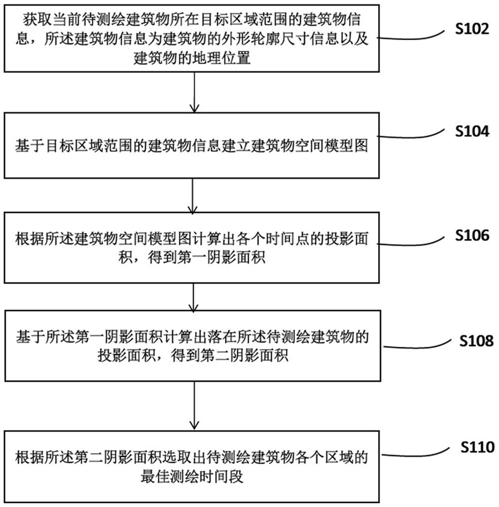
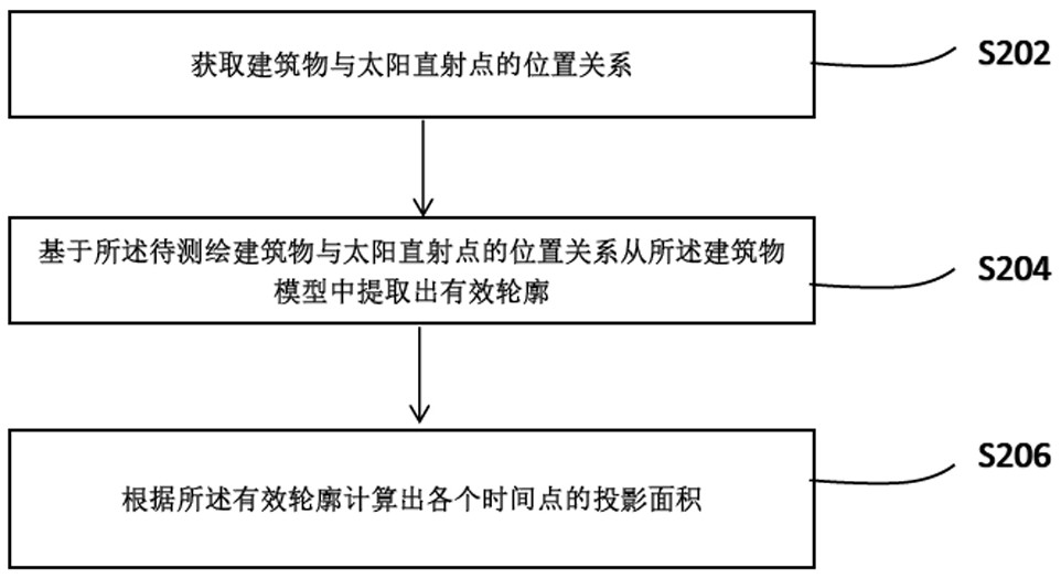
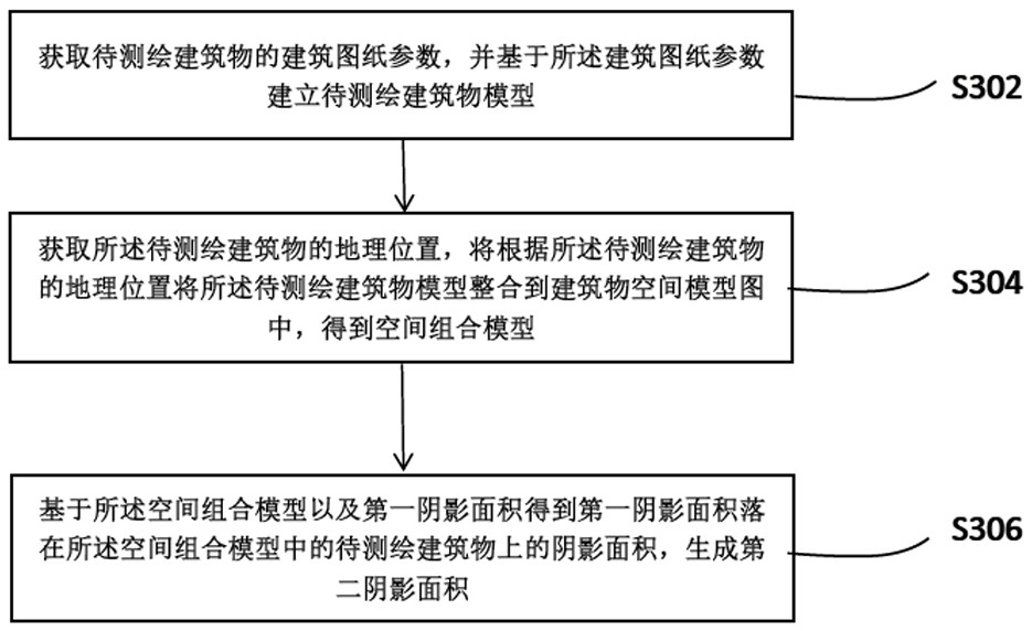
[0069] The first aspect of the present invention provides a method for building surveying and mapping based on UAV remote sensing, comprising the following steps:

[0070] S102: Obtain the building ...


PUM


Abstract

The invention relates to a building surveying and mapping method and system based on unmanned aerial vehicle remote sensing, and belongs to the field of building surveying and mapping, and the method comprises the steps: obtaining the building information of a target area range where a current to-be-surveyed building is located, the building information being the contour dimension information of the building and the geographic position of the building; building a building space model diagram based on the building information of the target area range; calculating a projection area of each time point according to the building space model graph to obtain a first shadow area; calculating the projection area of the building to be mapped based on the first shadow area to obtain a second shadow area; and selecting an optimal surveying and mapping time period of each area of the building to be surveyed and mapped according to the second shadow area. According to the method, on one hand, the surveying and mapping efficiency can be effectively improved, identification can be carried out according to the wall facilities on the building, when the wall facilities are smooth glass surfaces, the surveying and mapping points can be effectively selected, and the surveying and mapping accuracy is guaranteed.

Description

technical field [0001] The invention relates to the technical field of architectural surveying and mapping, in particular to a method and system for architectural surveying and mapping based on drone remote sensing. Background technique [0002] With the development of my country's engineering industry, the surveying and mapping industry has also ushered in a period of rapid development. Based on the rapid progress of my country's science and technology, it also provides a huge impetus to my country's engineering surveying and mapping industry. Because of the many advantages of UAV remote sensing technology, applying it in the engineering surveying and mapping industry can not only better complete modeling, data collection and processing, but also greatly improve the work efficiency of surveying and mapping personnel. Judging from the current situation, UAV remote sensing surveying and mapping technology has been widely used in the engineering field, and will surely become ...

Claims


Application Information

Patent Timeline
IPC IPC(8): G01C11/02G01B11/24G01W1/02G06T17/00G06N3/04G06N3/08
CPCG01C11/02G01B11/2433G01W1/02G06T17/00G06N3/04G06N3/08
Inventor 苏敏赵德良刘昊
Owner 山东省地矿测绘有限公司
Why Eureka
Try Eureka