Total station scanning all-in-one instrument based on three-dimensional laser surveying and mapping technology and measurement method

A three-dimensional laser, laser ranging technology, applied in the field of tunnel surveying and mapping, can solve the problems of long operation time, complex operation process, large tunnel error, etc., to achieve the effect of less personnel demand, high surveying and mapping efficiency, and reducing errors

Pending Publication Date: 2022-01-28
JIANGSU XCMG CONSTR MASCH RES INST LTD
View PDF17 Cites 4 Cited by
  • Summary
  • Abstract
  • Description
  • Claims
  • Application Information

AI Technical Summary

Problems solved by technology

This process has the following disadvantages: 1. Surveying and mapping requires total stations, positioning targets, and scanners at the same time, and the number of instruments is too large to carry; , the operation process is complex, requires many personnel, and the operation time is long, which affects the overall construction progress; 3. The obtained point cloud data needs to be processed by professional software before it can be converted into the geodetic coordinate system, and the bid is won in measuring and positioning target coordinates and identifying point clouds There are errors introduced in the target position, resulting in large errors in the calculation results of overbreak and underbreak in the final tunnel

Method used


Image

  • Total station scanning all-in-one instrument based on three-dimensional laser surveying and mapping technology and measurement method
  • Total station scanning all-in-one instrument based on three-dimensional laser surveying and mapping technology and measurement method
  • Total station scanning all-in-one instrument based on three-dimensional laser surveying and mapping technology and measurement method

Examples


Embodiment Construction

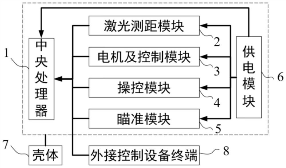
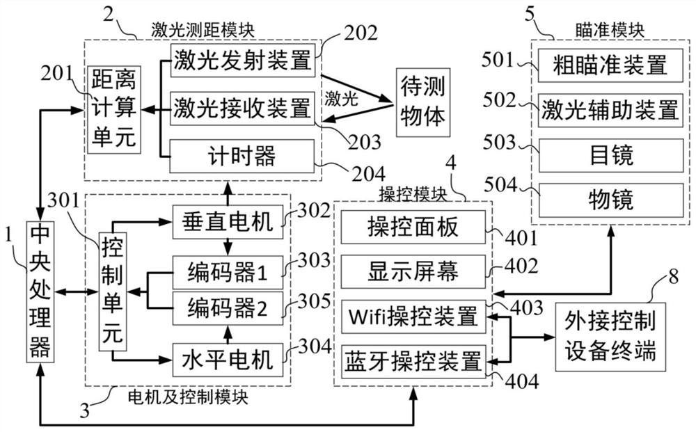
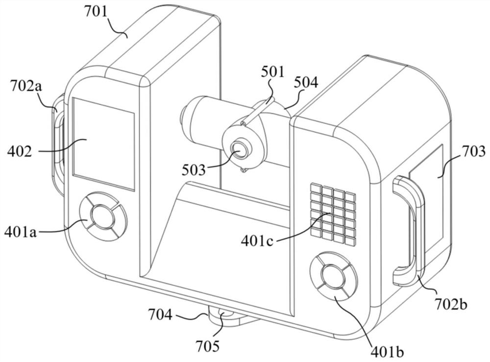
[0047] The technical solutions of the present invention will be described in conjunction with the drawings of the present invention, as will be described below. Based on the embodiments of the invention, those of ordinary skill in the art do not have all other embodiments obtained under creative labor conditions.

[0048] In the description of the invention, it is to be noted that the terms "upper", "lower", "left", "right", "top", "bottom", "inside", "horizontal", " Vertical "The orientation or positional relationship is based on the orientation or positional relationship shown in the drawings, and is intended to facilitate the description of the present invention and simplified description, rather than indicating or implying that the device or component must have a specific orientation. Structure and operation in a specific orientation, it is not understood to limit the limitations of the invention.

[0049] In the present invention, the earth coordinate system means that the ea...


PUM


Abstract

The invention discloses a total station scanning all-in-one instrument based on a three-dimensional laser surveying and mapping technology and a measuring method. The total station scanning all-in-one instrument comprises a central processing unit, a laser ranging module, a motor and control module, a control module, an aiming module, a power supply module, a shell and an external control equipment terminal. The positioning function of a three-dimensional laser scanner is realized by utilizing the free station setting principle of the total station, and a point cloud coordinate system obtained by scanning after positioning is directly a tunnel geodetic coordinate system; the invention designs a total station scanning all-in-one instrument which can achieve a self-positioning function by using two known coordinate control points and integrates a total station and a scanner, and provides a tunnel surveying and mapping method based on the instrument, the method omits the processes of target arrangement measurement, point cloud coordinate system transformation and the like, the operation is simple, and the surveying and mapping time can be shortened while personnel allocation is reduced.

Description

Technical field [0001] The present invention relates to the field of tunnel mapping techniques, and more particularly to a total station scan integral meter and measurement method based on three-dimensional laser mapping techniques. Background technique [0002] Due to the complex China terrain, the area is large, the tunnel construction has always been an important part of the construction of transportation network. According to the statistics of the International Tunnel and the underground space association (ITA), China's construction tunnel has reached 50% of the world's construction tunnel, which is the largest number of tunnels, the largest, and the fastest growing tunnel. During the tunnel excavation, it is difficult to avoid it. Directly affect the construction safety, cost, quality, and increase in the tunnel, and increase the difficulty of the next construction, and accurately obtain the basis for the timely adjustment of the subsequent construction process. The basis of...

Claims


Application Information

Patent Timeline
Patent Type & Authority Applications(China)
IPC IPC(8): G01C15/00G01S17/08
CPCG01C15/00G01S17/08
Inventor 李杨侯志强杨祥
Owner JIANGSU XCMG CONSTR MASCH RES INST LTD
Why Eureka
Try Eureka