Rainfall prediction method, system and electronic device

A forecasting method and rainfall technology, which is applied in the field of meteorological services, can solve the problems of coarse forecasting granularity, failure to consider the mutual movement and change relationship of clouds at different heights, and insufficient extraction of time series information, so as to achieve the effect of reducing errors

Active Publication Date: 2018-02-16
SHENZHEN INST OF ADVANCED TECH CHINESE ACAD OF SCI
11 Cites 72 Cited by

AI-Extracted Technical Summary

Problems solved by technology

Although this method utilizes radar map information and convolutional neural network, it has limited spatio-temporal information mining. It only uses a single-height radar map without considering the relationship between clouds at different heights. Insufficient extraction, and when radar images of di...

Method used

In step 100, the embodiment of the present application is by selecting a series of radar images of the same target site and surrounding areas at different heights in different time periods, and processing the radar images into specified sizes and dimensions, thereby predicting the target site The total amount of rainfall on the ground during a future time period. By making full use of radar maps with different height distributions, this application not only performs convolution on a single-height radar map plane, but also extracts the cloud layer information of the target area and surrounding areas. The relationship between the radar charts between adjacent heights, making full use of the radar chart data, avoids the information loss caused by the traditional method of using a single height radar chart, thereby improving the prediction accuracy. Specifically, the radar chart sample data includes the following dimensions:
The rainfall prediction method of the embodiment of the present application, system and electronic equipment are by using the radar map of different heights, and use 3D convolutional neural network to extract the cloud layer information of target area and peripheral area on the radar map plane of single height, simultaneously Learn the relationship between radar maps at adjacent heights, and automatically extract the spatial feature information of the radar map; then use the long-short-term memory cycle neural network to analyze the change trend of the spatial feature information of the radar map, the meteorological information sequence and the historical rainfall information for time series analysis , making effective use of the long-term and short-term time-series dependencies in the radar chart's changing trend over time, and incorporating other meteorological information, integrating multiple data sources to achieve the purpose of complementing each other's advantages, and better understanding the radar chart's changing trend over time and radar The relationship between the map and the rainfall is modeled to further reduce the error, so as to accurately predict the future rainfall in the short term; it can save time and effort, be efficient and fast, and avoid the traditional method of using a single-height radar map, which leads to information loss and increases the prediction error. Shortcomings.
[0078] Further, in the embodiment of the present application, the long short-term memory recurrent neural network includes a forget gate (forgetgate), an input gate (input gate) and an output gate (output gate). The gate is a method...

Abstract

The invention belongs to the meteorological service technical field and relates to a rainfall prediction method, a rainfall prediction system and an electronic device. The method comprises the following steps that: a) radar maps of different heights in different time periods and meteorological information sequences in the corresponding time periods are extracted; b) a deep neural network-based rainfall prediction model is constructed; and c) the extracted radar maps and the meteorological information sequences are inputted the rainfall prediction model, time series analysis is performed on theinputted radar maps and meteorological information sequences through the rainfall prediction model, so that radar map space-time characteristics and meteorological information time-series features corresponding to the time periods are obtained, and rainfall prediction values corresponding to the time periods are outputted according to the radar map space-time characteristics and the meteorological information time-series features. According to the rainfall prediction method, the rainfall prediction system and the electronic device of the invention, long-term and short-term time series dependencies in the trend of the change of the radar maps over time are fully utilized; other meteorological information is incorporated; a variety of data sources are synthesized; and therefore, short-termfuture rainfall can be accurately predicted.

Application Domain

Technology Topic

Image

  • Rainfall prediction method, system and electronic device
  • Rainfall prediction method, system and electronic device
  • Rainfall prediction method, system and electronic device

Examples

  • Experimental program(1)

Example Embodiment

[0063] In order to make the purpose, technical solutions, and advantages of this application clearer, the following further describes this application in detail with reference to the accompanying drawings and embodiments. It should be understood that the specific embodiments described herein are only used to explain the application, and not used to limit the application.
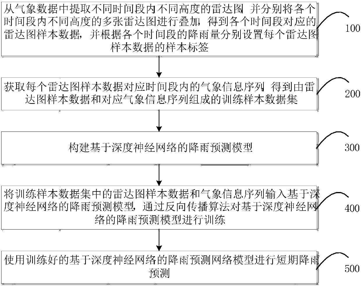
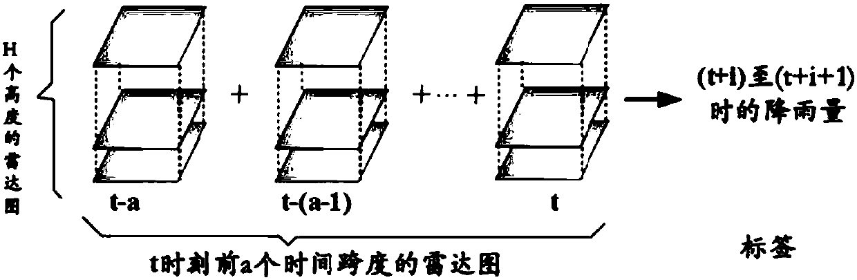
[0064] In the prior art, the traditional radar chart-based short-term rainfall prediction method only selects a radar chart of a single height for analysis, but because the radar chart in a certain period of time has multiple sheets of different heights, and the radar charts of different heights There is a mutual change relationship, a single height radar chart causes a lot of information loss and leads to large forecast errors. In order to solve the problems in the prior art, the rainfall prediction method of the embodiment of the present application superimposes multiple radar image data of different heights in the same time period, and uses a 3D convolutional neural network to extract the target on a single height radar image plane. The cloud information of the area and surrounding areas, while learning the relationship between the radar images at adjacent heights, and automatically extracting the spatial feature information of the radar images; then using the long- and short-term memory loop neural network to extract the temporal and spatial features of the radar image and the temporal features of weather information, thereby Precisely predict future rainfall in the short term.
[0065] Specifically, see figure 1 , Is a flowchart of the rainfall prediction method according to an embodiment of the present application. The rainfall prediction method of the embodiment of the application includes the following steps:
[0066] Step 100: Extract radar charts at different heights in different time periods from the weather data, and superimpose multiple radar charts at different heights in each time period to obtain the radar chart sample data corresponding to each time period, and according to each time period Set the sample label of each radar chart sample data for the rainfall of the segment;
[0067] In step 100, the embodiment of the present application selects a series of radar maps of the same target site and surrounding areas at different heights in different time periods, and processes the radar maps into specified sizes and dimensions, thereby predicting the target site’s future The total rainfall on the ground in a period of time. This application makes full use of radar maps with different height distributions, not only does convolution on the radar map plane of a single height, extracts the cloud information of the target area and surrounding areas, and at the same time performs convolution on the dimension of the radar map height to learn relative The relationship of the radar chart between adjacent heights makes full use of the radar chart data, avoiding the loss of information caused by the traditional method using a single height radar chart, thereby improving the prediction accuracy. Specifically, the radar chart sample data includes the following dimensions:
[0068] 1. Each radar chart sample data contains a target site (the target site is located in the center of the radar chart sample data);
[0069] 2. Each radar chart sample data contains the total rainfall of the target station in a certain period of time;
[0070] 3. Each radar chart sample data is composed of a radar chart superimposed on a time span. The radar chart under different time spans has an interval of 6 minutes, which can be set according to the actual application; the radar chart at different altitudes, total H heights; the specific data of a single radar chart sample is as figure 2 Shown is a radar chart of a time span before time t. The sample label of the radar chart sample data is the total rainfall from (t+i) to (t+i+1), and i is the time period after time t .
[0071] 4. According to the latitude and longitude of the target site, each radar chart sample data covers an area of ​​m*m square kilometers, and the area is marked as m×m grid; image 3 Shown is a schematic diagram of the target site, and the point at the center of the figure is the target site.
[0072] Step 200: Obtain the meteorological information sequence in the time period corresponding to each radar chart sample data, and obtain a training sample data set composed of the radar chart sample data and the corresponding meteorological information sequence;
[0073] In step 200, in order to maintain consistency with the radar chart sample data and facilitate processing, the wind speed, temperature, air pressure, humidity and other weather information sequences corresponding to the time period of the radar chart sample data are extracted from the weather information collected by the weather station. And process the extracted weather information sequence into vector form.
[0074] Step 300: Construct a rainfall prediction model based on a deep neural network;
[0075] In step 300, the rainfall prediction model based on the deep neural network of the embodiment of the present application includes two parts: a 3D convolutional neural network and a long and short-term memory cyclic neural network. The rainfall prediction model based on the deep neural network includes two implementation methods, such as Figure 4 Shown is the network architecture diagram of the first implementation. The first implementation method is to completely separate the radar chart sample data from the meteorological information sequence: This method first extracts the radar chart spatiotemporal features in the radar chart sample data through the 3D convolutional neural network and the long short-term memory neural network, and then according to the extracted radar chart spatiotemporal characteristics The feature predicts the first rainfall; then the time series features of the meteorological information sequence are extracted through the long and short-term memory neural network, and the second rainfall is predicted based on the time series features of the meteorological information; finally the two predicted rainfalls are weighted and fused to obtain the final Rainfall forecast value.
[0076] See Figure 5 , Is the network architecture diagram of the second implementation mode. The second way is to implement convolution operations on each radar chart sample data through a 3D convolutional neural network to obtain the radar chart spatial characteristic information for each time period, and input the radar chart spatial characteristic information and weather information sequence into the long and short term The memory loop neural network performs time series analysis to obtain the time-space characteristics of the radar chart and the time series characteristics of meteorological information. The final rainfall forecast value is obtained by integrating the distribution of cloud cover and its changing trend in the surrounding area and the changing trend of meteorological information. Since the two implementation manners are substantially similar in implementation details, the following embodiments of the present application only take the second implementation manner as an example for specific description, and the specific implementation manner can be selected according to actual conditions.
[0077] Specifically, please refer to Figure 4 , Is the overall architecture diagram of the rainfall prediction model based on the deep neural network in the embodiment of the present application. The rainfall prediction model based on the deep neural network in the embodiment of the application includes: an input layer, a first convolutional layer, a correction layer, a pooling layer, a second convolutional layer, a fully connected layer, and an output layer; the radar image is input through the input layer The sample data and meteorological information sequence are respectively convolved through the first convolutional layer on the radar chart sample data of each time period, and corrected and pooled through the correction layer and the pooling layer, then the second convolutional layer Output the radar map spatial feature information for each time period, and connect it to the long and short-term memory loop neural network through the fully connected layer, and learn the radar map spatial feature information and the change trend of the weather information sequence over time through the long and short-term memory loop neural network. The time and space characteristics of the radar chart and the time series characteristics of weather information in each time period, and finally the rainfall forecast value is output through the output layer.
[0078] Further, in the embodiment of the present application, the long-short-term memory cyclic neural network includes a forget gate, an input gate, and an output gate. A gate is a method of letting information pass through selectively. The three gate structures can remove or add the radar map spatial feature information and weather information sequence to the cell state of the long and short-term memory neural network, that is, the radar map spatial feature information and weather information sequence Can be selectively forgotten and preserved through 3 door structures. Use the forget gate to select the radar map spatial feature information and the effective information in the weather information sequence in real time, discard the invalid information, and then add the new radar map spatial feature information and weather information sequence through the input gate, so as to cycle back and forth, long and short-term memory cycle nerves The network can learn the long-term dependence information in the radar map spatial feature information and weather information sequence, and mine the change trend of the radar map spatial feature information and weather information sequence, thereby reducing prediction errors.
[0079] Specifically, please refer to Image 6 , Is a schematic diagram of the three door structures in the embodiment of the present application. The functions of the forget gate, input gate and output gate are as follows:
[0080] 1. Forgetting gate: It is used for selective memory and forgetting of the long-term memory of the spatial feature information of the radar chart and the weather information sequence; because each radar chart sample data and weather information sequence includes the radar chart and the radar chart at the current moment and multiple past moments. Weather information sequence, but some information extracted from radar charts and weather information sequences at multiple times in the past may become invalid information over time. Therefore, it is necessary to discard this part of invalid information through the forgetting gate, and retain the information from multiple times in the past. Information that is still valid in the radar chart and weather information sequence. The Forgotten Gate is based on the input of the current radar chart and weather information sequence and the output of the previous time (that is, the information in the radar chart and weather information sequence accumulated in the past that will have an immediate impact on the current time. ), output a forgotten parameter between 0 and 1 Where 0 means completely forgetting the radar chart and weather information sequence accumulated in the past, and 1 means completely remembering the radar chart and weather information sequence accumulated in the past.
[0081] 2. Input gate: used to save the effective information in the radar chart and weather information sequence input at the current moment, and then add it to the long-term memory of the radar chart and weather information sequence C t in. In the embodiment of the present application, the input gate uses the radar chart and weather information sequence input at the current time and the output at the previous time (that is, the information in the radar chart and weather information sequence accumulated in the past that will have an immediate impact on the current time. ) Determine the degree of influence of the current radar chart and weather information sequence on the overall radar chart and weather information sequence i t , And then the forgetting parameters obtained by the forgetting gate Extract long-term memory C t The effective information of the radar chart and weather information sequence in, the influence degree i obtained by the input gate t Extract the useful long-term memory of the radar chart and weather information sequence from the radar chart and weather information sequence input at the current moment, and update the long-term memory of the radar chart and weather information sequence C t.
[0082] 3. The output gate is used to obtain information that will have an immediate impact on the next moment from the accumulated radar chart and meteorological information sequence The output gate is based on the long-term memory of the radar chart and weather information sequence at the current moment C t And the radar chart and weather information sequence input at the current moment, that is, the long-term memory of the radar chart and weather information sequence C t Reflects the overall change trend of the radar chart and weather information sequence extracted from the previous information, plus the radar chart and weather information sequence input at the current time, it can reflect the radar chart and weather information sequence at the next time to a certain extent Expectations.
[0083] Step 400: Input the radar chart sample data and weather information sequence in the training sample data set into the rainfall prediction model based on the deep neural network, and train the rainfall prediction model based on the deep neural network through the back propagation algorithm;
[0084] In step 400, the training method for training the rainfall prediction model based on the deep neural network includes the following steps:
[0085] Step 410: Initialize the parameters of the rainfall prediction model based on the deep neural network;
[0086] Step 420: Input the radar map sample data with rainfall tags and the weather information sequence into the rainfall prediction model based on the deep neural network;
[0087] Step 430: Perform continuous convolution pooling operation on the radar map sample data of each time period through the 3D convolutional neural network, and extract the radar map spatial feature information of each time period;
[0088] Step 440: Input the extracted radar map spatial feature information and weather information sequence for each time period into the long and short-term memory cyclic neural network, and extract the radar map spatiotemporal features and the weather information timing characteristics through the long and short-term memory cyclic neural network, and according to the radar map time and space Features and time series features of meteorological information output the rainfall forecast value of each time period;
[0089] Step 450: Calculate the loss function L according to the output rainfall prediction value and the rainfall error in the sample label;
[0090] Step 460: Determine whether the loss function L meets the minimum value, if it does not meet the minimum value, go to step 470; if it meets the minimum value, go to step 480;
[0091] In step 460, since the goal of this application is to predict the exact rainfall to reduce the prediction error, this application uses the root mean square error (RMSE) as the loss function to evaluate the performance; RMSE is defined as follows:
[0092]
[0093] In the above formula, X is the prediction vector, Y is the vector of observation values, and n is the size of the observation data.
[0094] Step 470: Use the back propagation algorithm to adjust the network parameters according to the loss function L until the loss function L meets the minimum value;
[0095] Step 480: Save the network parameters, and the model training ends.
[0096] Step 500: Use the trained rainfall prediction network model based on the deep neural network to perform short-term rainfall prediction.
[0097] In step 500, to predict the rainfall in a certain time period in the future (i-th time to i+1-th time) at the current time in a certain target area, only a few hours before the current time need to be extracted with the target area as the center The radar chart and weather information sequence of a time span within the range of mxm are processed into the same form as the training sample data set, and then input to the rainfall prediction model based on the deep neural network. The rainfall prediction model automatically completes the extraction of the temporal and spatial characteristics of the radar map, the modeling of the transformation trend of the radar map in the space and time domain, the modeling of the relationship between the radar map and the corresponding rainfall, and the modeling of the trend of the weather information over time As well as the modeling process of the relationship between meteorological information and corresponding rainfall, and directly output the rainfall forecast value of the i-th to i+1-th time period after the current moment, eliminating the need for manual estimation process, saving time and effort, and convenient to use.
[0098] See Figure 7 , Is a schematic structural diagram of the rainfall prediction system of the embodiment of the present application. The rainfall prediction system of the embodiment of the application includes a radar image extraction module, a meteorological information extraction module, a network model construction module, a network model training module, and a rainfall prediction module.
[0099] Radar map extraction module: used to extract radar maps of different heights in different time periods from meteorological data, and superimpose multiple radar maps of different heights in each time period to obtain the radar map sample data corresponding to each time period; Among them, the embodiment of the present application selects a series of radar images of the same target site and surrounding areas at different heights in different time periods, and processes the radar images into specified sizes and dimensions, thereby predicting the target site in a certain time period in the future Total rainfall within the ground. Specifically, the radar chart sample data includes the following dimensions:
[0100] 1. Each radar chart sample data contains a target site (the target site is located in the center of the radar chart sample data);
[0101] 2. Each radar chart sample data contains the total rainfall of the target site in a certain period of time;
[0102] 3. Each radar chart sample data is composed of a radar chart superimposed on a time span. The radar chart under different time spans has an interval of 6 minutes, which can be set according to the actual application; the radar chart at different altitudes, total H heights; the specific data of a single radar chart sample is as figure 2 Shown is a radar chart of a time span before time t. The sample label of the radar chart sample data is the total rainfall from (t+i) to (t+i+1), and i is the time period after time t .
[0103] 4. According to the latitude and longitude of the target site, each radar chart sample data covers an area of ​​m*m square kilometers, and the area is marked as m×m grid; image 3 Shown is a schematic diagram of the target site, and the point in the center of the figure is the target site.
[0104] Meteorological information extraction module: used to obtain the meteorological information sequence within the corresponding time period of each radar chart sample data; among them, in order to maintain consistency with the radar chart sample data and facilitate processing, the meteorological information collected from the weather station is extracted from the radar Map the meteorological information sequence of wind speed, temperature, pressure, humidity, etc. corresponding to the time period of the sample data, and process the extracted meteorological information sequence into a vector form.
[0105] Network model building module: used to construct a rainfall prediction model based on a deep neural network; among them, the rainfall prediction model based on a deep neural network in this embodiment of the application includes two parts: a 3D convolutional neural network and a long- and short-term memory cyclic neural network. The rainfall prediction model of the neural network includes two implementation methods. The first implementation method is to completely separate the radar chart sample data from the meteorological information sequence: this method first extracts the radar chart sample data through the 3D convolutional neural network and the long short-term memory neural network Based on the time-space features of the radar map, predict the first rainfall based on the extracted time-space features of the radar map; then use the long-short-term memory neural network to extract the time-series features of the weather information sequence, and predict the second rainfall based on the time-series features of the weather information; The two rainfalls are weighted and merged to obtain the final rainfall prediction value.
[0106] The second way is to implement convolution operations on each radar chart sample data through a 3D convolutional neural network to obtain the radar chart spatial characteristic information for each time period, and input the radar chart spatial characteristic information and weather information sequence into the long and short term The memory loop neural network performs time series analysis to obtain the time-space characteristics of the radar chart and the time series characteristics of meteorological information. The final rainfall forecast value is obtained by integrating the distribution of cloud cover and its changing trend in the surrounding area and the changing trend of meteorological information. Since the two implementations are substantially similar in implementation details, the following embodiments of the present application only take the second implementation as an example for specific description.
[0107] Specifically, it is an overall architecture diagram of a rainfall prediction model based on a deep neural network in an embodiment of the present application. The rainfall prediction model based on the deep neural network in the embodiment of the application includes: an input layer, a first convolutional layer, a correction layer, a pooling layer, a second convolutional layer, a fully connected layer, and an output layer; the radar image is input through the input layer The sample data and meteorological information sequence are respectively convolved through the first convolutional layer on the radar chart sample data of each time period, and corrected and pooled through the correction layer and the pooling layer, then the second convolutional layer Output the radar map spatial feature information of each time period, and fully connect to the long and short-term memory loop neural network through the fully connected layer, and extract the radar map space-time features and meteorological information timing characteristics of each time period through the long and short-term memory loop neural network, and finally pass The output layer outputs the predicted rainfall value.
[0108] Further, in the embodiment of the present application, the long-short-term memory cyclic neural network includes a forget gate, an input gate, and an output gate. A gate is a method of letting information pass through selectively. The three gate structures can remove or add the radar map spatial feature information and weather information sequence to the cell state of the long and short-term memory neural network, that is, the radar map spatial feature information and weather information sequence Can be selectively forgotten and preserved through 3 door structures. Use the forget gate to select the radar map spatial feature information and the effective information in the weather information sequence in real time, discard the invalid information, and then add the new radar map spatial feature information and weather information sequence through the input gate, so as to cycle back and forth, long and short-term memory cycle nerves The network can learn the long-term dependence information in the radar map spatial feature information and weather information sequence, and mine the change trend of the radar map spatial feature information and weather information sequence, thereby reducing prediction errors. Specifically, the functions of the forget gate, input gate, and output gate are as follows:
[0109] 1. Forgetting gate: It is used for selective memory and forgetting of the long-term memory of the spatial feature information of the radar chart and the weather information sequence; because each radar chart sample data and weather information sequence includes the radar chart and the radar chart at the current moment and multiple past moments. Weather information sequence, but some information extracted from radar charts and weather information sequences at multiple times in the past may become invalid information over time. Therefore, it is necessary to discard this part of invalid information through the forgetting gate, and retain the information from multiple times in the past. Information that is still valid in the radar chart and weather information sequence. According to the input of the radar chart and weather information sequence at the current time and the output of the previous time (that is, the information accumulated in the radar chart and weather information sequence in the past that will have an immediate impact on the current time), the forget gate outputs a value between 0 and 1. Forgotten parameters Where 0 means completely forgetting the radar chart and weather information sequence accumulated in the past, and 1 means completely remembering the radar chart and weather information sequence accumulated in the past.
[0110] 2. Input gate: used to save the effective information in the radar chart and weather information sequence input at the current moment, and then add it to the long-term memory of the radar chart and weather information sequence C t in. In the embodiment of this application, the input gate determines the current time through the input of the radar chart and weather information sequence at the current time and the output of the previous time (that is, the information in the radar chart and weather information sequence accumulated in the past that will have an immediate impact on the current time) The degree of influence of radar chart and weather information sequence on the overall radar chart and weather information sequence i t , And then the forgetting parameters obtained by the forgetting gate Extract long-term memory C t The effective information of the radar chart and weather information sequence in, the influence degree i obtained by the input gate t Extract the useful long-term memory of the radar chart and weather information sequence from the radar chart and weather information sequence input at the current moment, and update the long-term memory of the radar chart and weather information sequence C t.
[0111] 3. The output gate is used to obtain information that will have an immediate impact on the next moment from the accumulated radar chart and meteorological information sequence The output gate is based on the long-term memory of the radar chart and weather information sequence at the current moment C t And the radar chart and weather information sequence input at the current moment, that is, the long-term memory of the radar chart and weather information sequence C t Reflects the overall change trend of the radar chart and weather information sequence extracted from the previous information, plus the radar chart and weather information sequence input at the current time, it can reflect the radar chart and weather information sequence at the next time to a certain extent Expectations.
[0112] Network model training module: It is used to form a training sample data set according to the radar chart sample data and the corresponding weather information sequence, and input the radar chart sample data and weather information sequence in the training sample data set into the rainfall prediction model based on the deep neural network. The direction propagation algorithm trains the rainfall prediction model based on the deep neural network; specifically, the network model training module includes:
[0113] Initialization unit: used to initialize the parameters of the rainfall prediction model based on the deep neural network;
[0114] Sample input unit: used to input the radar map sample data and meteorological information sequence with rainfall tags into the rainfall prediction model based on deep neural network;
[0115] The first feature extraction unit: used to perform continuous convolution pooling operation on the radar chart sample data of each time period through the 3D convolutional neural network, and extract the radar image spatial feature information of each time period;
[0116] The second feature extraction unit: used to input the extracted radar map spatial feature information and weather information sequence of each time period into the long and short-term memory cyclic neural network, and extract the radar map spatiotemporal features and weather information time series features through the long and short-term memory cyclic neural network, And according to the time-space characteristics of the radar chart and the time-series characteristics of the weather information, the forecast value of the rainfall in each time period is output;
[0117] Loss function calculation unit: used to calculate the loss function L according to the output rainfall forecast value and the rainfall error in the sample label;
[0118] Loss function value judgment unit: used to judge whether the loss function L satisfies the minimum value, if the minimum value is not satisfied, the network parameters are optimized by the network optimization unit; if the minimum value is satisfied, the network parameters are stored by the parameter storage unit; The goal is to predict the exact rainfall in order to reduce the prediction error. Therefore, this application uses the root mean square error (RMSE) as a loss function to evaluate performance; RMSE is defined as follows:
[0119]
[0120] In the above formula, X is the prediction vector, Y is the vector of observation values, and n is the size of the observation data.
[0121] Network optimization unit: used to use the back propagation algorithm to adjust network parameters according to the loss function L until the loss function L meets the minimum value;
[0122] Parameter storage unit: used to save network parameters, and the model training ends.
[0123] Rainfall prediction module: used for short-term rainfall prediction using the trained rainfall prediction network model based on deep neural network. Among them, to predict the rainfall in a certain time period in the future (i-th time to i+1-th time) at the current time of a certain target area, you only need to take the target area as the center to extract the range of mxm several hours before the current time A time-span radar chart and weather information sequence, after processing the radar chart and weather information sequence into the same form as the training sample data set, input the rainfall prediction model based on deep neural network, and pass the rainfall prediction model based on deep neural network Automatically complete the extraction of the temporal and spatial characteristics of the radar map, the modeling of the transformation trend of the radar map in the space and time domain, the modeling of the relationship between the radar map and the corresponding rainfall, the modeling of the trend of weather information over time, and the weather information The modeling process of the relationship with the corresponding rainfall, and directly output the rainfall forecast value for the i-th to i+1-th time period after the current moment, eliminating the need for manual estimation process, saving time and effort, and convenient to use.
[0124] Figure 8 It is a schematic diagram of the hardware device structure of the rainfall prediction method provided by the embodiment of the present invention, such as Figure 8 As shown, the device includes one or more processors and memory. Taking a processor as an example, the device may also include: an input system and an output system.
[0125] The processor, memory, input system and output system can be connected by bus or other means, Figure 8 Take the bus connection as an example.
[0126] As a non-transitory computer-readable storage medium, the memory can be used to store non-transitory software programs, non-transitory computer executable programs and modules. The processor executes various functional applications and data processing of the electronic device by running non-transitory software programs, instructions, and modules stored in the memory, that is, realizing the processing methods of the foregoing method embodiments.
[0127] The memory may include a program storage area and a data storage area, where the program storage area can store an operating system and an application program required by at least one function; the data storage area can store data and the like. In addition, the memory may include a high-speed random access memory, and may also include a non-transitory memory, such as at least one magnetic disk storage device, a flash memory device, or other non-transitory solid-state storage devices. In some embodiments, the memory may optionally include a memory remotely provided with respect to the processor, and these remote memories may be connected to the processing system through a network. Examples of the aforementioned networks include, but are not limited to, the Internet, corporate intranets, local area networks, mobile communication networks, and combinations thereof.
[0128] The input system can receive input digital or character information, and generate signal input. The output system may include display devices such as a display screen.
[0129] The one or more modules are stored in the memory, and when executed by the one or more processors, the following operations of any of the foregoing method embodiments are performed:
[0130] Step a: Extracting radar images of different heights in different time periods and meteorological information sequences in the corresponding time periods;
[0131] Step b: Construct a rainfall prediction model based on a deep neural network;
[0132] Step c: Input the extracted radar chart and weather information sequence into the rainfall prediction model, and perform time sequence analysis on the input radar chart and weather information sequence through the rainfall prediction model to obtain the radar chart time-space characteristics and weather information sequence corresponding to each time period According to the temporal and spatial characteristics of the radar chart and the time sequence characteristics of the weather information, the rainfall prediction values ​​corresponding to each time period are output.
[0133] The above-mentioned products can execute the methods provided in the embodiments of the present invention, and have corresponding functional modules and beneficial effects for executing the methods. For technical details not described in detail in this embodiment, refer to the method provided in the embodiment of the present invention.
[0134] The embodiment of the present invention provides a non-transitory (non-volatile) computer storage medium, the computer storage medium stores computer executable instructions, and the computer executable instructions can perform the following operations:
[0135] Step a: Extracting radar images of different heights in different time periods and meteorological information sequences in the corresponding time periods;
[0136] Step b: Construct a rainfall prediction model based on a deep neural network;
[0137] Step c: Input the extracted radar chart and weather information sequence into the rainfall prediction model, and perform time sequence analysis on the input radar chart and weather information sequence through the rainfall prediction model to obtain the radar chart time-space characteristics and weather information sequence corresponding to each time period According to the temporal and spatial characteristics of the radar chart and the temporal characteristics of the weather information, the forecasted rainfall value corresponding to each time period is output.
[0138] The embodiment of the present invention provides a computer program product, the computer program product includes a computer program stored on a non-transitory computer-readable storage medium, the computer program includes program instructions, when the program instructions are executed by a computer To make the computer do the following:
[0139] Step a: Extracting radar images of different heights in different time periods and meteorological information sequences in the corresponding time periods;
[0140] Step b: Construct a rainfall prediction model based on a deep neural network;
[0141] Step c: Input the extracted radar chart and weather information sequence into the rainfall prediction model, and perform time sequence analysis on the input radar chart and weather information sequence through the rainfall prediction model to obtain the radar chart time-space characteristics and weather information sequence corresponding to each time period According to the temporal and spatial characteristics of the radar chart and the temporal characteristics of the weather information, the forecasted rainfall value corresponding to each time period is output.
[0142] The rainfall prediction method, system, and electronic equipment of the embodiments of the application use radar images of different heights, and use a 3D convolutional neural network to extract cloud information of the target area and surrounding areas on a radar image plane of a single height, while learning adjacent The relationship between the high-altitude radar chart, and automatically extract the spatial characteristic information of the radar chart; then through the long and short-term memory loop neural network, the change trend of the radar chart spatial characteristic information and the time series analysis of the meteorological information sequence and historical rainfall information are used effectively It integrates the long-term and short-term timing dependence of the radar chart over time, integrates other meteorological information, integrates multiple data information sources, and achieves the purpose of complementing each other. It can better understand the radar chart over time and the radar chart and rainfall. Modeling the inter-relationships further reduces errors and accurately predicts future rainfall in the short term. It saves time and effort, is efficient and fast, and avoids the shortcomings of traditional methods that use a single altitude radar map, which leads to information loss and increases prediction errors.
[0143] The foregoing description of the disclosed embodiments enables those skilled in the art to implement or use this application. Various modifications to these embodiments will be obvious to those skilled in the art, and the general principles defined in this document can be implemented in other embodiments without departing from the spirit or scope of the application. Therefore, this application will not be limited to the embodiments shown in this text, but should conform to the widest scope consistent with the principles and novel features disclosed in this text.

PUM

no PUM

Description & Claims & Application Information

We can also present the details of the Description, Claims and Application information to help users get a comprehensive understanding of the technical details of the patent, such as background art, summary of invention, brief description of drawings, description of embodiments, and other original content. On the other hand, users can also determine the specific scope of protection of the technology through the list of claims; as well as understand the changes in the life cycle of the technology with the presentation of the patent timeline. Login to view more.

Similar technology patents

Dual-CPU based circuit breaker intelligent controller

Owner:WUHAN NARI LIABILITY OF STATE GRID ELECTRIC POWER RES INST

Classification and recommendation of technical efficacy words

Why Eureka
Try Eureka