Method for calculating three-dimensional position of ground point based on sequence satellite-borne SAR image

A three-dimensional position and ground point technology, applied in the field of remote sensing image processing, can solve the problems of complex calculation process and unsuitable for large-scale engineering applications.

Active Publication Date: 2018-02-23
中科卫星山东科技集团有限公司
View PDF6 Cites 7 Cited by
  • Summary
  • Abstract
  • Description
  • Claims
  • Application Information

AI Technical Summary

Problems solved by technology

[0004] Using the serialized satellite SAR images to calculate the three-dimensional position of the ground point, it is also possible to extract two SAR images from the sequence images each time to perform the conventional relative orientation and absolute orientation complex non-linear iterative

Method used


Image

  • Method for calculating three-dimensional position of ground point based on sequence satellite-borne SAR image
  • Method for calculating three-dimensional position of ground point based on sequence satellite-borne SAR image
  • Method for calculating three-dimensional position of ground point based on sequence satellite-borne SAR image

Examples


Embodiment Construction

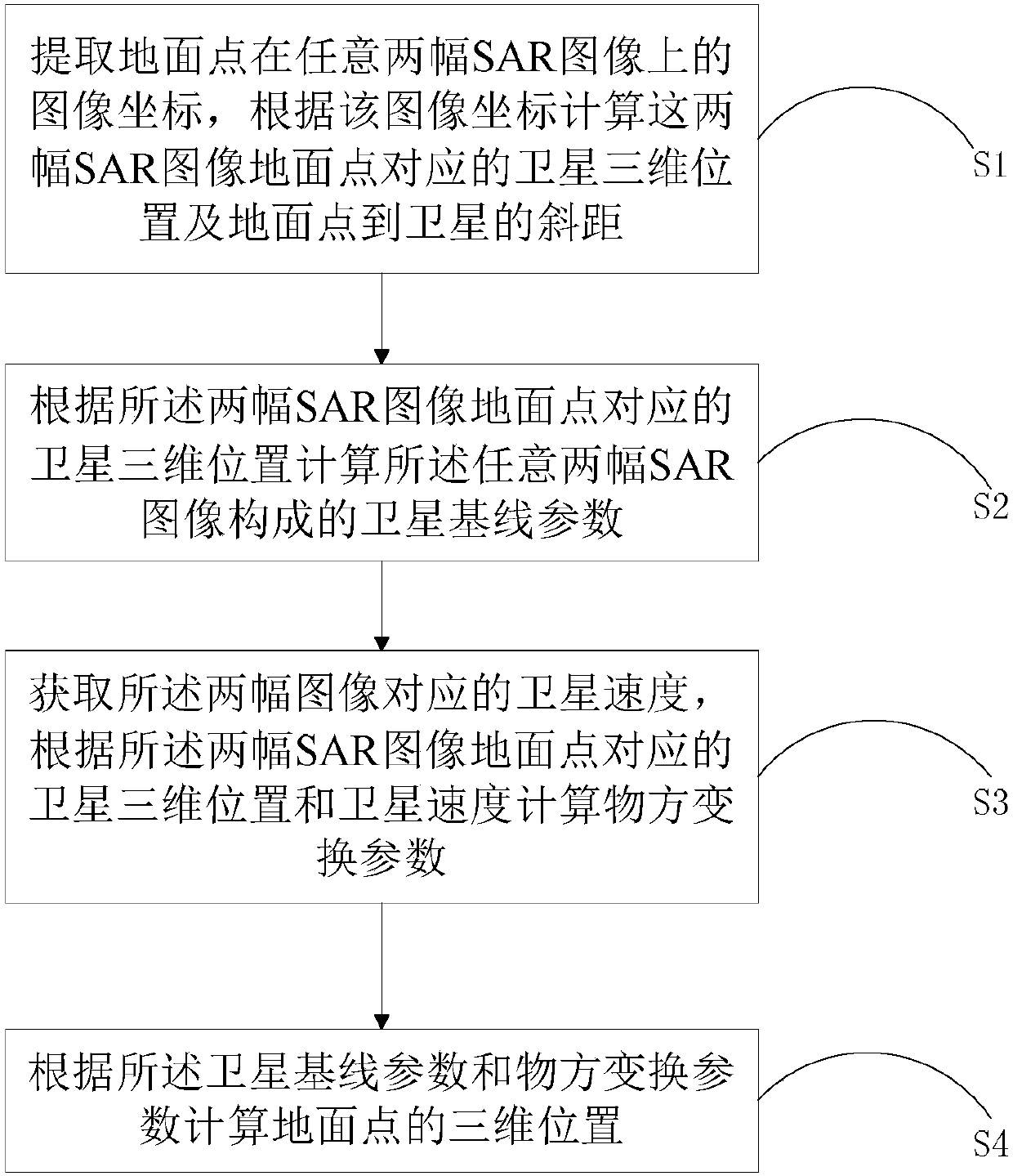
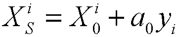
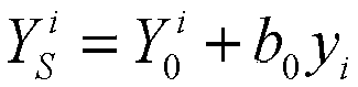
[0047] In order to make the purpose, technical solutions and advantages of the present disclosure clearer, the present disclosure will be further described in detail below in conjunction with specific embodiments and with reference to the accompanying drawings.

[0048] It should be noted that, in the drawings or descriptions of the specification, similar or identical parts all use the same figure numbers. Implementations not shown or described in the accompanying drawings are forms known to those of ordinary skill in the art. Additionally, while illustrations of parameters including particular values ​​may be provided herein, it should be understood that the parameters need not be exactly equal to the corresponding values, but rather may approximate the corresponding values ​​within acceptable error margins or design constraints. The directional terms mentioned in the embodiments, such as "upper", "lower", "front", "rear", "left", "right", etc., are only referring to the dire...


PUM


Abstract

The invention provides a method for calculating a three-dimensional position of a ground point based on a sequence satellite-borne SAR image. The method comprises following steps of S1, extracting image coordinates of any two SAR images of a ground point, and calculating a satellite three-dimensional position and the slope distance between the ground point and the satellite according to the imagecoordinates; S2, calculating satellite base line parameters formed by any two SAR images according to the satellite three-dimensional position; S3, acquiring satellite speed corresponding to the two SAR images, and calculating object space conversion parameters according to the satellite three-dimensional position and the satellite speed; and S4, calculating the three-dimensional position of the ground point according to the object space conversion parameters and the object space conversion parameters. According to the invention, the three-dimensional position of the ground point is calculatedin a directly displayed manner by applying the platform parameters and the system parameters of the satellite-borne SAR remote sensing image without an initial approximate value of the ground point;there is no any iteration and approximation process in the calculation; the calculation efficiency is improved; and large-scale engineering application is facilitated.

Description

technical field [0001] The present disclosure relates to the technical field of remote sensing image processing, in particular to a method for calculating a three-dimensional position of a ground point based on a sequence of spaceborne SAR images. Background technique [0002] Spaceborne Synthetic Aperture Radar (SAR for short, hereinafter referred to as SAR) remote sensing images can only obtain two-dimensional image information on the ground after geometric positioning or geometric correction. method to get the 3D information of the ground point. Stereo image pair is to calculate the three-dimensional position of the ground point by using the spatial geometric relationship between the two images acquired in the same area. The conventional processing flow is to go through two major processes of relative orientation and absolute orientation, and each process requires a relatively complicated process. Iterative calculation, the three-dimensional position accuracy of the grou...

Claims


Application Information

Patent Timeline
IPC IPC(8): G01S13/90
CPCG01S13/904G01S13/9027
Inventor 尤红建
Owner 中科卫星山东科技集团有限公司
Why Eureka
Try Eureka