Offshore wind energy resource assessment method based on multi-source remote sensing satellite wind speed correction

A wind energy resource assessment and remote sensing satellite technology, which is applied in the field of offshore wind energy resource assessment based on multi-source remote sensing satellite wind speed correction, can solve the problems such as the evaluation research system has not yet been formed, and the offshore wind energy resource assessment is in its infancy, and achieves low cost and reliability. Data sources and assessment methods, the effect of accurate wind energy resources

Active Publication Date: 2018-03-06
ZHEJIANG UNIV
View PDF8 Cites 0 Cited by
  • Summary
  • Abstract
  • Description
  • Claims
  • Application Information

AI Technical Summary

Problems solved by technology

The research on wind energy resources in my country began in the 1980s and 1990s. my country's meteorological department carried out multi-level surveys and resource assessments of wind energy resources across the country. Th...

Method used


Image

  • Offshore wind energy resource assessment method based on multi-source remote sensing satellite wind speed correction
  • Offshore wind energy resource assessment method based on multi-source remote sensing satellite wind speed correction
  • Offshore wind energy resource assessment method based on multi-source remote sensing satellite wind speed correction

Examples


Embodiment Construction

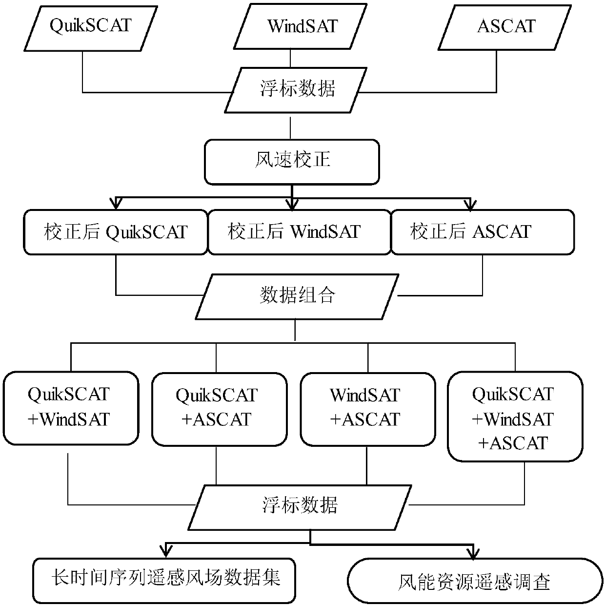
[0052] The present invention will be further described below in conjunction with specific drawings and embodiments.

[0053] Step 1. Collect and organize multi-source satellite remote sensing wind field data sets (QuikSCAT, WindSAT, ASCAT) from 1999 to 2015;

[0054] The embodiment of the present invention collects and organizes QuikSCAT scatterometer data from 1999-2009, WindSAT radiometer data from 2003-2015, ASCAT scatterometer data from 2007-2015 (http: / / data.remss.com / ), using IDL language Write a program to read information such as transit time, latitude and longitude, instantaneous wind field, whether there is rain, etc. in QuikSCAT, WindSAT and ASCAT files.

[0055] Step 2. Collect and organize global maritime buoy data sets that match the time and space of satellite data;

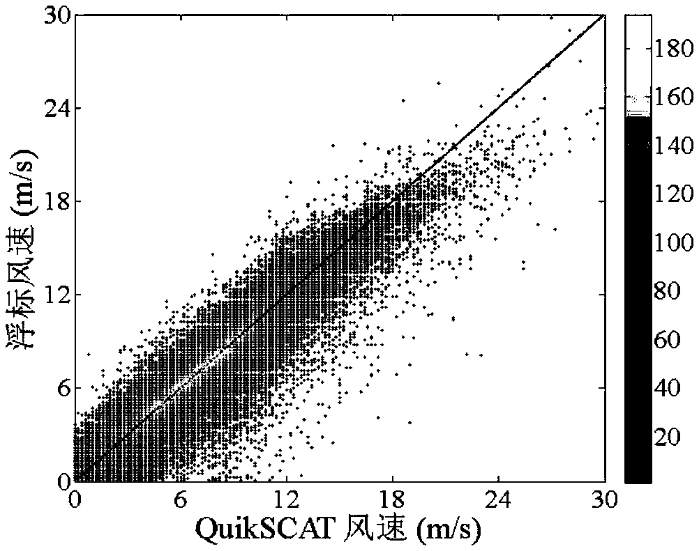
[0056] The present invention collects and organizes 39 American buoys (NDBC) data from 1999 to 2015 for comparison with satellite remote sensing data (http: / / www.ndbc.noaa.gov / ), using the longitu...


PUM


Abstract

The invention discloses an offshore wind energy resource assessment method based on multi-source remote sensing satellite wind speed correction. The method includes a first step of collecting and sorting long-time sequence multi-source satellite remote sensing wind field data sets (QuikSCAT, WindSAT and ASCAT); a second step of collecting and sorting a global oceanographic buoy data set that matches the space-time of satellite data; a third step of correcting the satellite wind speed by using a linear relationship between the buoy wind speed and the satellite wind speed; a fourth step of determining, according to the international and national standards for wind power generation, remote sensing assessment indicators for offshore wind energy resources; and a fifth step of calculating and comparing wind energy resource assessment results for different satellite combinations and the corresponding buoys. The method in the invention is conducive to the establishment of offshore wind energyresource survey methods based on satellite remote sensing data and provides low-cost and reliable data sources and assessment methods for offshore wind energy resource surveys.

Description

technical field [0001] The invention relates to the technical fields of remote sensing, energy and meteorology, in particular to a method for assessing offshore wind energy resources based on multi-source remote sensing satellite wind speed correction. Background technique [0002] The energy issue is a major issue restricting the current and future economic and social development of our country. Since the reform and opening up, the economy and society in my country's coastal areas have developed rapidly, and the demand for energy has grown rapidly. Facing the fact that traditional energy sources in this area are relatively scarce, and the potential for the development and utilization of offshore wind energy resources is huge, it is particularly important to develop offshore wind energy resources. urgent. With the advancement of science and technology, the acquisition of satellite remote sensing data and the advancement of satellite remote sensing wind field inversion method...

Claims


Application Information

Patent Timeline
IPC IPC(8): G06Q10/06G06Q50/06G01W1/00
Inventor 郭乔影黄敬峰张康宇
Owner ZHEJIANG UNIV
Why Eureka
Try Eureka