Hybrid-cloud-based centimeter-level real-time positioning system and implementing method thereof

A technology of real-time positioning and implementation method, applied in the field of navigation and positioning, can solve the problems of high equipment requirements, low availability and high cost, and achieve the effect of saving computing resources

Inactive Publication Date: 2018-04-03
QIANXUN SPATIAL INTELLIGENCE INC
View PDF13 Cites 7 Cited by
  • Summary
  • Abstract
  • Description
  • Claims
  • Application Information

AI Technical Summary

Problems solved by technology

The difference is generally divided into carrier phase differential data and pseudorange differential data, which are used for terminal equipment to perform carrier phase differential (RTK, Real Time Kinematic) positioning and pseudorange differential (RTD, Real Time Differential) positioning respectively. Carrier phase differential positioning, High precision, but high equipment requirements, high cost, low availability, mainly used in the field of surveying and mapping; pseudo-range differential positioning, low equipment requirements, low cost, high availability, moderate accuracy, can be used in civil navigation

Method used


Image

  • Hybrid-cloud-based centimeter-level real-time positioning system and implementing method thereof
  • Hybrid-cloud-based centimeter-level real-time positioning system and implementing method thereof
  • Hybrid-cloud-based centimeter-level real-time positioning system and implementing method thereof

Examples


Embodiment Construction

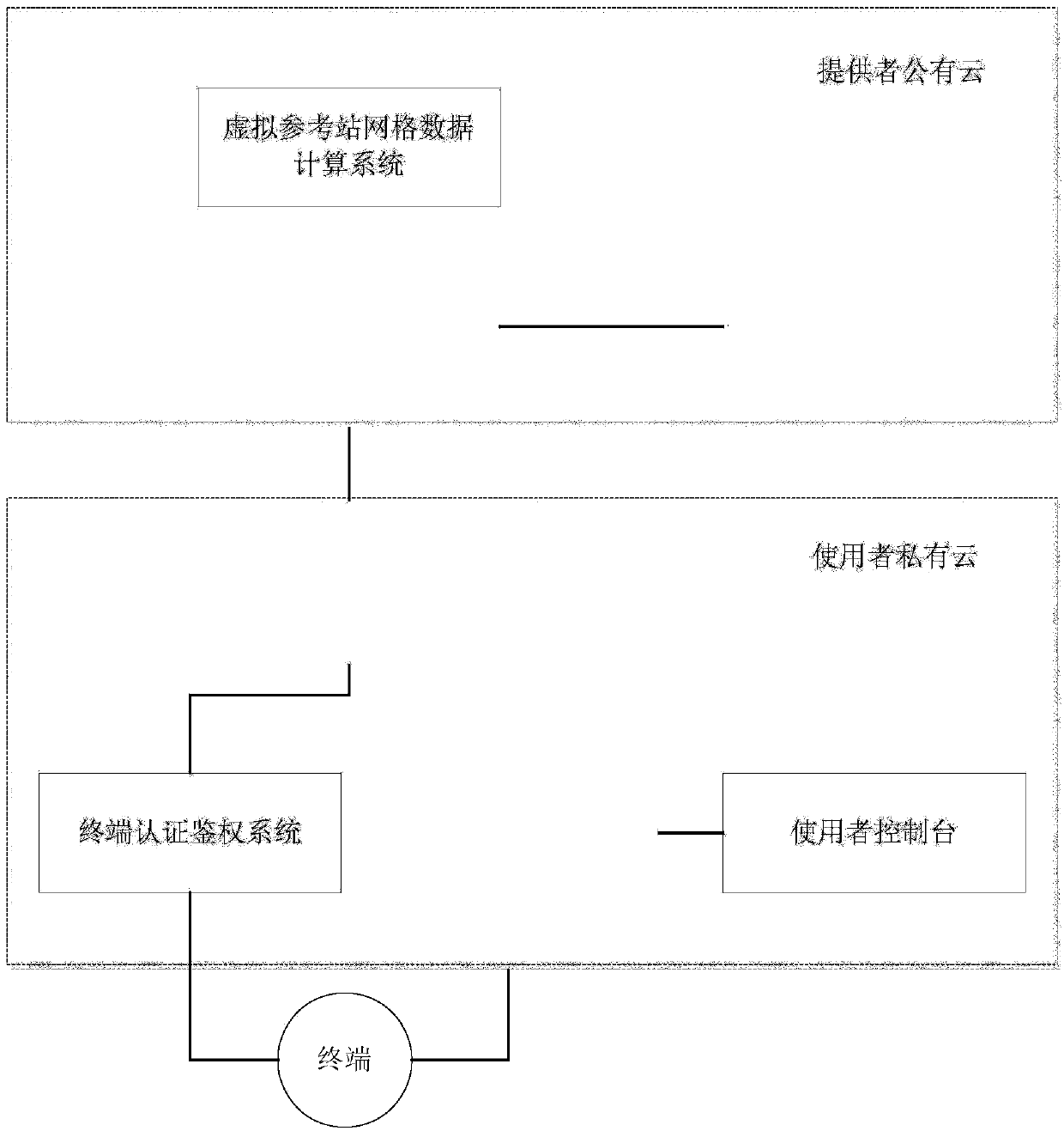
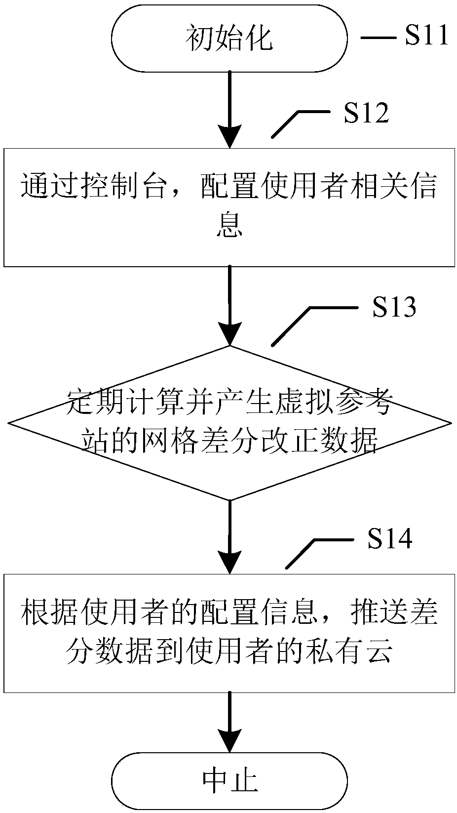
[0055] The present invention provides a hybrid cloud-based centimeter-level real-time positioning system and its implementation method:

[0056] 1. The calculation of the grid points of the virtual reference station is performed on the provider's public cloud;

[0057] 2. The data of the virtual reference station is pushed to the user's private cloud as needed;

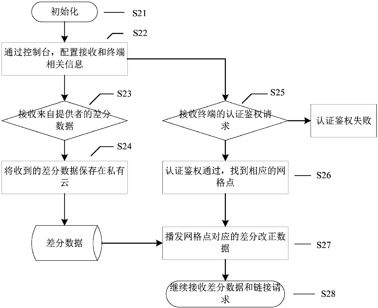
[0058] 3. The user's terminal is connected to the user's own private cloud;

[0059] 4. After the authentication is passed, the terminal sends its own probability position to the user's own private cloud;

[0060] 5. The differential data dissemination system on the user's own private cloud broadcasts the differential correction data of the grid of the corresponding virtual reference station according to the probability position uploaded by the terminal.

[0061] Hereinafter, the present invention will be further described in conjunction with the drawings and embodiments.

[0062] figure 1 It is a system architect...


PUM


Abstract

The invention provides a hybrid-cloud-based centimeter-level real-time positioning system and an implementing method thereof, characterized in that 1, grid points of a virtual reference station are calculated on a public cloud of a provider; 2, data of the virtual reference station are pushed to a private cloud of a user as required; 3, a terminal of the user is connected to the private cloud of the user; 4, after authorization and authentication are passed, the terminal transmits its own probability position to the private cloud of the user; 5, a broadcasting system on the private cloud of the user broadcasts a differential correction of a grid of the corresponding virtual reference station according to the probability position uploaded by the terminal. The public cloud and the private cloud are hybridized and matched; the personal solution saves calculation resources and meets the enterprise user safety specification.

Description

technical field [0001] The invention relates to the technical field of navigation and positioning, in particular to a hybrid cloud-based centimeter-level real-time positioning system and an implementation method. Background technique [0002] Public cloud: Public cloud usually refers to a cloud that can be used by third-party providers for users. Public clouds are generally available through the Internet, and may be free or low-cost. The core attribute of public clouds is shared resource services. There are many instances of this cloud, providing services throughout today's open public web. [0003] Private Cloud: Private Clouds are built for the sole use of a customer, thus providing the most effective control over data, security and quality of service. The company owns the infrastructure and can control how applications are deployed on this infrastructure. Private clouds can be deployed inside the firewall of an enterprise data center, or they can be deployed in a secure...

Claims


Application Information

Patent Timeline
Patent Type & Authority Applications(China)
IPC IPC(8): H04L29/08H04L29/06
CPCH04L63/08H04L67/10H04L67/30H04L67/52H04L67/55
Inventor 周睿谢志军张亿沙晓杰
Owner QIANXUN SPATIAL INTELLIGENCE INC
Why Eureka
Try Eureka