Algorithm for positioning accurate mountain fire and calculating vertical distance between mountain fire edge and overhead transmission line

An overhead transmission line and precise positioning technology, which is applied in the field of wildfire locations, can solve the problems of large impact, high cost, and inability to meet the pre-alarm of wildfires in overhead transmission lines.

Inactive Publication Date: 2018-04-27
HAINAN POWER GRID CO LTD ELECTRIC POWER RES INST
View PDF4 Cites 7 Cited by
  • Summary
  • Abstract
  • Description
  • Claims
  • Application Information

AI Technical Summary

Problems solved by technology

[0002] Overhead transmission lines are mainly operated in the wild and are greatly affected by the environment. In particular, accidents caused by mountain fires near overhead transmission lines have occurred frequently. Traditional mountain fire monitoring mainly uses visible light video or infrared thermal imaging technology. Since visible light video cannot Calculating the precise positioning

Method used


Image

  • Algorithm for positioning accurate mountain fire and calculating vertical distance between mountain fire edge and overhead transmission line
  • Algorithm for positioning accurate mountain fire and calculating vertical distance between mountain fire edge and overhead transmission line
  • Algorithm for positioning accurate mountain fire and calculating vertical distance between mountain fire edge and overhead transmission line

Examples


Embodiment Construction

[0030] In order to better understand the technical content of the present invention, specific embodiments are provided below, and the present invention is further described in conjunction with the accompanying drawings.

[0031] The present invention provides an algorithm for the precise positioning of wildfires and the vertical distance from the edge of wildfires to overhead transmission lines, and the steps of the method are as follows:

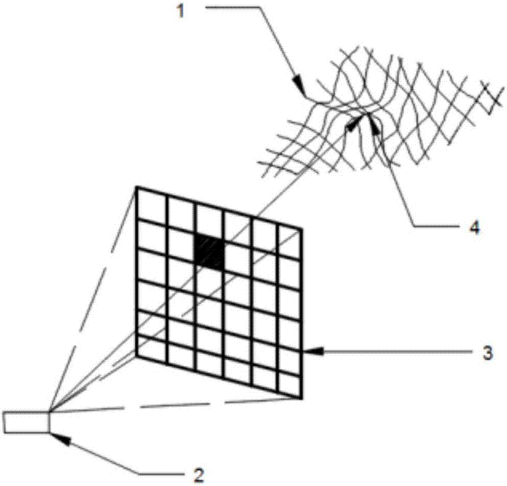
[0032] (1) see figure 1 and figure 2 , after discovering the fire through the camera, based on the principle of photogrammetry, construct the image plane two-dimensional coordinate system o-xy, the image space Cartesian coordinate system S-xyz, the ground photographic coordinate system O-XYZ, and the image space auxiliary coordinate system S-XYZ, Among them, p is the image point, P is the fire point, S is the origin of the camera photography center, and o is the origin of the image center;

[0033] (2) Use the three-dimensional electroni...


PUM


Abstract

The invention discloses an algorithm for positioning the accurate mountain fire and calculating a vertical distance between a mountain fire edge and an overhead transmission line. After the mountain fire is discovered through a camera, a planar two-dimensional coordinate system o-xy, an image space rectangular coordinate system S-xyz, a ground photography coordinate system O-XYZ and an image spaceauxiliary coordinate system S-XYZ are constructed based on the photogrammetry principle, p is an image point, P is a fire point, S is the origin of the camera photographic center, and o is the originof the image center; three-dimensional attitude angles during image shooting are measured through utilizing a three-dimensional electronic compass fixedly mounted on the camera in real time, including the azimuth angle (phi), tehe inclination angle (omega) and the roll angle (kappa); through image point space coordinate transformation, a collinear conditional equation satisfying the image point p, the fire point P and the origin S of the camera photographic center is constructed, and the equal-division search method is utilized to acquire the three-dimensional coordinate of the fire point.

Description

technical field [0001] The invention relates to an algorithm for the location of wildfires, in particular to an algorithm for the precise positioning of wildfires and the vertical distance from the edge of wildfires to overhead transmission lines. Background technique [0002] Overhead transmission lines are mainly operated in the wild and are greatly affected by the environment. In particular, accidents caused by mountain fires near overhead transmission lines have occurred frequently. Traditional mountain fire monitoring mainly uses visible light video or infrared thermal imaging technology. Since visible light video cannot Calculating the precise positioning of wildfires and the vertical distance from the edge of wildfires to overhead transmission lines cannot meet the requirements for early warning of wildfires on overhead transmission lines; infrared thermal imaging technology can achieve precise positioning of wildfires, but it is expensive and cannot achieve the edge o...

Claims


Application Information

Patent Timeline
IPC IPC(8): G06T17/05G06T7/70G01C11/04
CPCG06T17/05G01C11/04G06T7/70
Inventor 陈钦柱赵海龙黄松余阳
Owner HAINAN POWER GRID CO LTD ELECTRIC POWER RES INST
Why Eureka
Try Eureka