Spatial data measuring method and device
A technology of spatial data and measurement methods, applied in the field of information processing, can solve problems such as inability to measure and obstacles in the measurement process, and achieve the effect of fast distance and convenient volume measurement
- Summary
- Abstract
- Description
- Claims
- Application Information
AI Technical Summary
Problems solved by technology
Method used
Image
Examples
Embodiment Construction
[0039] The technical solutions of the present invention will be described in detail below through the accompanying drawings and specific embodiments. It should be understood that the embodiments of the present invention and the specific technical features in the embodiments are only descriptions of the technical solutions of the present invention, rather than limitations. , the embodiments of the present invention and specific technical features in the embodiments may be combined with each other.
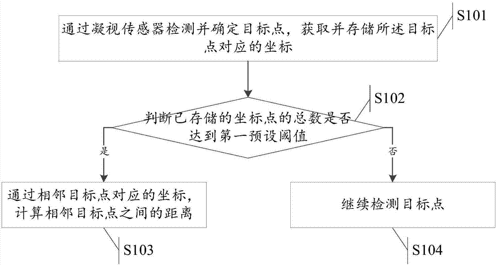
[0040] Such as figure 1 Shown is a flow chart of a spatial data measurement method in an embodiment of the present invention, the method comprising:
[0041] S101. Detect and determine a target point through a gaze sensor, and acquire and store coordinates corresponding to the target point;
[0042] S102, judging whether the total number of stored coordinate points reaches a first preset threshold;
[0043] If yes, execute S103; if not, execute S104.
[0044] S103, calculating th...
PUM
 Abstract
Description
Claims
Application Information
 - R&D
- Intellectual Property
- Life Sciences
- Materials
- Tech Scout
- Unparalleled Data Quality
- Higher Quality Content
- 60% Fewer Hallucinations
Browse by: Latest US Patents, China's latest patents, Technical Efficacy Thesaurus, Application Domain, Technology Topic, Popular Technical Reports.
© 2025 PatSnap. All rights reserved.Legal|Privacy policy|Modern Slavery Act Transparency Statement|Sitemap|About US| Contact US: help@patsnap.com


