Navigation method and device in regional map

A map and area technology, applied in the field of map navigation, can solve the problem of inability to achieve navigation, and achieve the effect of convenience for users

Active Publication Date: 2020-12-15
青岛融汇通投资控股有限公司
View PDF9 Cites 0 Cited by
  • Summary
  • Abstract
  • Description
  • Claims
  • Application Information

AI Technical Summary

Problems solved by technology

[0003] In view of this, the object of the present invention is to provide a navigation method and device in an area map, so as to alleviate the problem that the existing navigation software in the prior art cannot realize navigation in the entire specific area.

Method used


Image

  • Navigation method and device in regional map
  • Navigation method and device in regional map
  • Navigation method and device in regional map

Examples


Embodiment Construction

[0056] In order to make the purpose, technical solutions and advantages of the embodiments of the present invention clearer, the technical solutions of the present invention will be clearly and completely described below in conjunction with the accompanying drawings. Obviously, the described embodiments are part of the embodiments of the present invention, not all of them. the embodiment. Based on the embodiments of the present invention, all other embodiments obtained by persons of ordinary skill in the art without making creative efforts belong to the protection scope of the present invention.

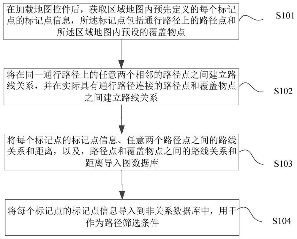
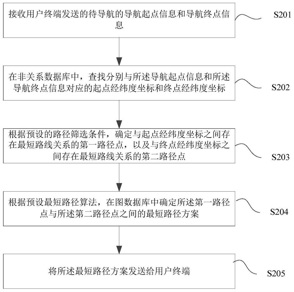
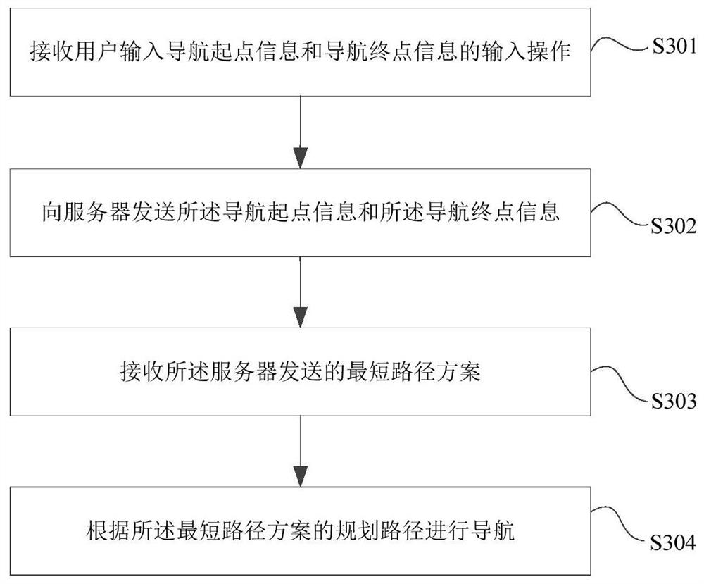
[0057]At present, the existing navigation software cannot realize the navigation of the entire specific area. It is used for situations where detours or turns may occur, which may cause inconvenience to users. Based on this, the embodiment of the present invention provides a navigation method and device in an area map, which establishes a navigation based on a graph database and a no...


PUM


Abstract

The invention provides a navigation method and device for a regional map and relates to the technical field of map navigation. The method comprises the following steps: receiving navigation starting point information and navigation destination information sent by a user terminal; searching starting point longitude and latitude coordinates corresponding to the navigation starting point informationand destination longitude and latitude coordinates corresponding to the navigation destination information respectively in a non-relational database; determining a first waypoint having the shortest path relation with the starting point longitude and latitude coordinates and a second waypoint having the shortest path relation with the destination longitude and latitude coordinates according to default path screening conditions; determining the shortest path scheme between the first waypoint and the second waypoint in a graph database according to a default shortest path algorithm; sending theshortest path scheme to the user terminal. According to the navigation method for the regional map, a navigation model based on the graph database and the non-relational database is established for the specific region and plans the shortest path for a user, so that navigation demands of the user in the specific region (such as a scenic spot) can be met, and convenience is brought to the user.

Description

technical field [0001] The invention relates to the field of map navigation, in particular to a navigation method and device in an area map. Background technique [0002] When the user travels, he often uses the mobile phone navigation software for route planning, that is, input the names of the starting point and the end point, the navigation software provides the planned route, and the user moves forward according to the planned route to reach the destination. When the user wants to go to a certain scenic spot or amusement park to play, the existing navigation software can only realize navigation to a certain location of the scenic spot or playground from the starting point input by the user, but cannot realize navigation in the entire play area, such as from When the Ferris wheel goes to the carousel, the user may detour or turn around when walking along the road, which brings inconvenience to the user. Contents of the invention [0003] In view of this, the object of ...

Claims


Application Information

Patent Timeline
Patent Type & Authority Patents(China)
IPC IPC(8): G01C21/34G01C21/20
CPCG01C21/20G01C21/3453
Inventor 王顺志张帅魏继鑫
Owner 青岛融汇通投资控股有限公司
Why Eureka
Try Eureka