
Vehicle driving information spatiotemporal index and big data analysis method

A technology of vehicle driving and analysis methods, which is applied in the field of space-time indexing of vehicle driving information and big data analysis, can solve the problem of insufficient information concentration, achieve the effects of saving storage space, making traffic management more intelligent, and easy to promote in practice

Pending Publication Date: 2018-08-21
JIANGSU UNIV
View PDF3 Cites 2 Cited by
  • Summary
  • Abstract
  • Description
  • Claims
  • Application Information

AI Technical Summary

Problems solved by technology

This method has a large compression ratio for video, but in today's big data environment, the "information density" is still not high enough

Method used


Image

  • Vehicle driving information spatiotemporal index and big data analysis method
  • Vehicle driving information spatiotemporal index and big data analysis method
  • Vehicle driving information spatiotemporal index and big data analysis method

Examples


Embodiment Construction

[0028] The present invention will be further described below in conjunction with the accompanying drawings.

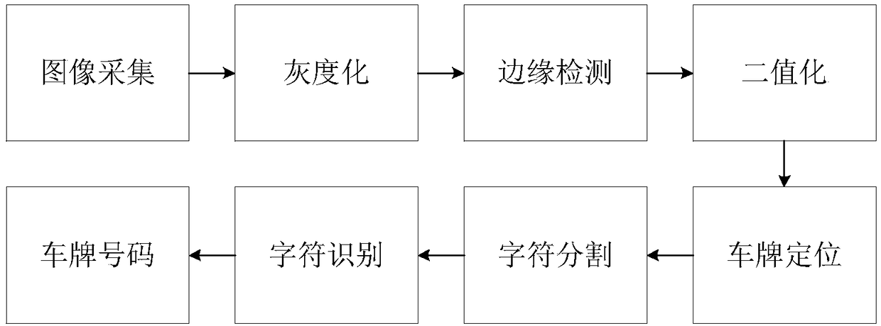
[0029] figure 1 It is a schematic diagram of the license plate recognition process. The space-time index of vehicle driving information and the big data analysis method need to be based on the license plate recognition technology. The license plate recognition includes image acquisition, grayscale, edge detection, binarization, license plate positioning, character segmentation, character recognition, License plate number several steps.

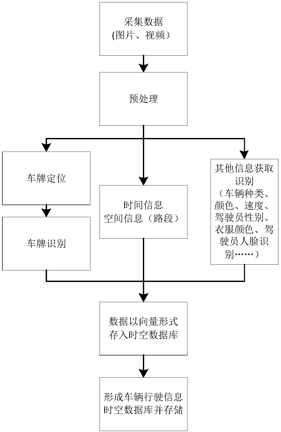
[0030] figure 2 Processes for establishing a spatio-temporal database include:

[0031] 1), data collection: use the existing camera monitoring at each intersection, and each camera has a unique ID, thus forming a virtual map of the city; when the vehicle is driving on the urban road, the camera at the current intersection uses Machine vision technology, labeling various target objects from the original video, such as recognizing t...


PUM


Abstract

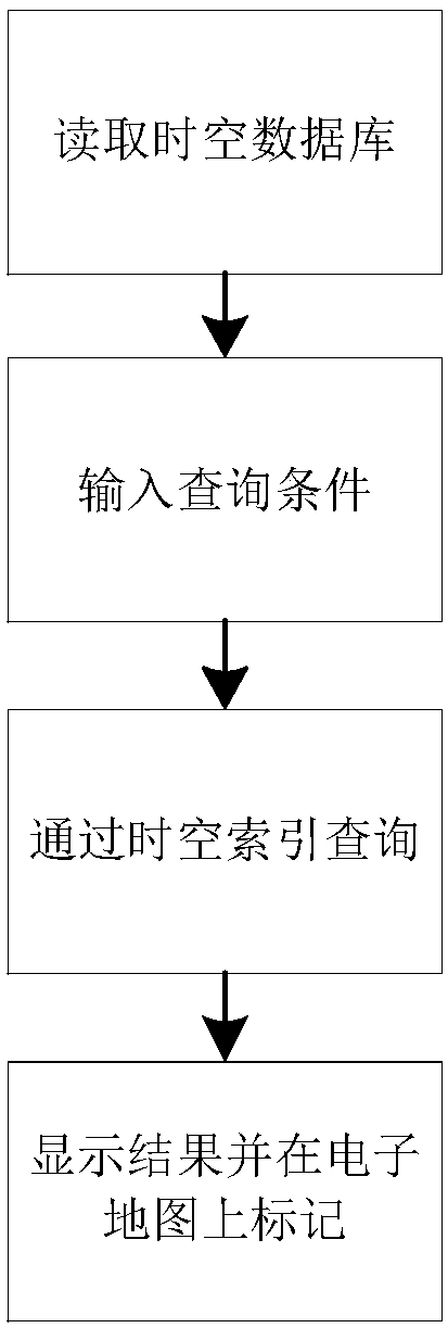
The invention discloses a vehicle driving information spatiotemporal index and big data analysis method, and belongs to the technical field of intelligent traffic. The method comprises the five stepsof collecting data; preprocessing the data; establishing a spatiotemporal database; performing index query; and performing big data analysis. A system stores the data in a vector form, has the advantages of massive storage in content, dynamic expansion in application and random embedding in propagation, and meets a propagation demand of realizing man-machine interaction. The potential of existingcameras can be mined; effective and reliable detection and tracking of vehicles on roads can be effectively ensured; the labor intensity of related working personnel can be reduced; a large amount oftime is saved; and the method can be used in the fields of road traffic management, safety protection and the like.

Description

technical field [0001] The invention belongs to the technical field of intelligent transportation, and in particular relates to a space-time index of vehicle driving information and a big data analysis method. Background technique [0002] At present, my country's highway traffic is developing rapidly, and the number of cars is increasing. Intelligent Transport System (Intelligent Transport System, ITS) is an effective way to solve the problems caused by the rapid development of traffic. It effectively integrates advanced information technology, communication technology, sensor technology, control technology and computer technology for the entire traffic management The system, which enables people, vehicles and roads to coordinate harmoniously and closely, has been highly valued by various countries and has developed rapidly. However, with the development of the transportation industry and the increase of traffic volume, traffic security videos in traditional highway traffi...

Claims


Application Information

Patent Timeline
IPC IPC(8): G06F17/30
CPCG06F16/7867G06F16/735G06F16/7837
Inventor 陈龙刘昌宁梁军杨艺熊晓夏
Owner JIANGSU UNIV
Learn More