Unmanned aerial vehicle follow-up taking-off and landing system

A technology for unmanned aerial vehicles and airborne systems, applied in the field of unmanned aerial vehicles, can solve the problems of poor accuracy, manual operation, long time consumption, etc., and achieve the effects of accurate positioning, precise take-off and landing, and low cost

Pending Publication Date: 2018-08-24
成都远致科技有限公司
View PDF0 Cites 2 Cited by
  • Summary
  • Abstract
  • Description
  • Claims
  • Application Information

AI Technical Summary

Problems solved by technology

[0002] At present, with the development of science and technology, various types of drones appear in the public's field of vision, but the existing drone technology, the precise fixed-point landing of drones requires manual operation, poor accuracy, and low intelligence
Because GPS positioning is used, there will be drift errors, and the positioning of the aircraft itself has errors,

Method used


Image

  • Unmanned aerial vehicle follow-up taking-off and landing system
  • Unmanned aerial vehicle follow-up taking-off and landing system
  • Unmanned aerial vehicle follow-up taking-off and landing system

Examples


Example Embodiment

[0020] In order to make the objectives, technical solutions and advantages of the present invention clearer, the present invention will be further described in detail below with reference to the accompanying drawings.

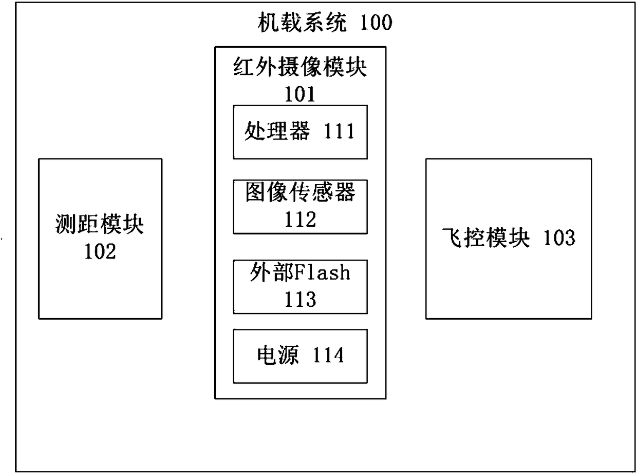
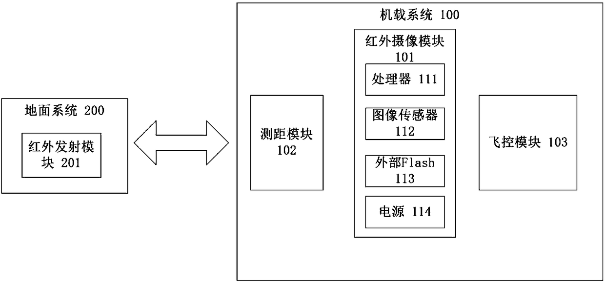
[0021] Such as figure 1 As shown, an unmanned aerial vehicle follow-up and landing system disclosed in the present invention includes an airborne system 100 and a ground system 200. The ground system 200 includes an infrared emission module 201, which is used for taking off and landing. The area emits infrared signals; the airborne system 100 includes an infrared camera module 101, a ranging module 102 and a flight control module 103. The ranging module 102 is used to measure the height of the drone from the ground. The flight control module 103 Used to control the flight movements of the drone, the infrared camera module 101 and the ranging module 102 are all communicatively connected with the flight control module 103; the infrared camera module 101 includes a pr...


PUM


Abstract

The present invention discloses an unmanned aerial vehicle follow-up taking-off and landing system. The system comprises an airborne system and a ground system. The ground system comprise an infraredemission module configured to emit infrared signals at a taking-off and landing area; and the airborne system comprises an infrared camera module, a distance measurement module and a flight control module, the distance measurement module is configured to measure the height from an unmanned aerial vehicle to the ground, the flight control module is configured to control flight motion of the unmanned aerial vehicle, and the infrared camera module, the distance measurement module and the flight control module are in communication connection. The objective of the invention is to provide the unmanned aerial vehicle follow-up taking-off and landing system, through identification of infrared rays, the unmanned aerial vehicle follow-up taking-off and landing system reduces the identification difficulty and external disturbance and achieves the all-day intelligent identification; through combination with the GPS, the system can achieve accurate location taking-off and landing, is simple and reliable in mode and lower in depending on a link; and moreover, through combination of the control exposure intensity and a filtering algorithm, the original image is single, the filtering difficulty isreduced, and the reliability is increased.

Description

technical field [0001] The invention relates to the technical field of unmanned aerial vehicles, in particular to an unmanned aerial vehicle follow-up take-off and landing system. Background technique [0002] At present, with the development of science and technology, various types of unmanned aerial vehicles (UAVs) appear in the public's field of vision. However, with the existing UAV technology, the precise fixed-point landing of UAVs requires manual operation, which has poor accuracy and low intelligence. Because GPS positioning is used, there will be drift errors, and the positioning of the aircraft itself has errors, making it difficult to land accurately. Or use RTK, the positioning is accurate, but due to the constraints of distance and cost, as well as the influence of instability, the application is difficult. Because of the inability to land accurately, on some specific landing platforms, most drones cannot land accurately, or it takes a long time to manually lan...

Claims


Application Information

Patent Timeline
IPC IPC(8): G05D1/12G05D1/10H04N5/33
CPCH04N5/33G05D1/101G05D1/12
Inventor 童建军蒲泓宇栗源兴
Owner 成都远致科技有限公司
Why Eureka
Try Eureka