Depth distance measuring method, device, computer readable storage medium and electronic equipment

A technology of depth distance and installation position, applied in the field of drones, can solve problems such as inaccurate depth distance and unfavorable real-time obstacle avoidance of drones

Inactive Publication Date: 2018-09-04
沈阳上博智像科技有限公司
View PDF6 Cites 12 Cited by
  • Summary
  • Abstract
  • Description
  • Claims
  • Application Information

AI Technical Summary

Problems solved by technology

However, the depth distance measured in this way is not accurate
Take the forward-facing binocular camera installed in front of the UAV frame as an example. If the UAV flies forward according to a certain pitch angle, the forward-facing binocular camera also has a certain ...

Method used


Image

  • Depth distance measuring method, device, computer readable storage medium and electronic equipment
  • Depth distance measuring method, device, computer readable storage medium and electronic equipment
  • Depth distance measuring method, device, computer readable storage medium and electronic equipment

Examples


Embodiment Construction

[0093] Specific embodiments of the present disclosure will be described in detail below in conjunction with the accompanying drawings. It should be understood that the specific embodiments described here are only used to illustrate and explain the present disclosure, and are not intended to limit the present disclosure.

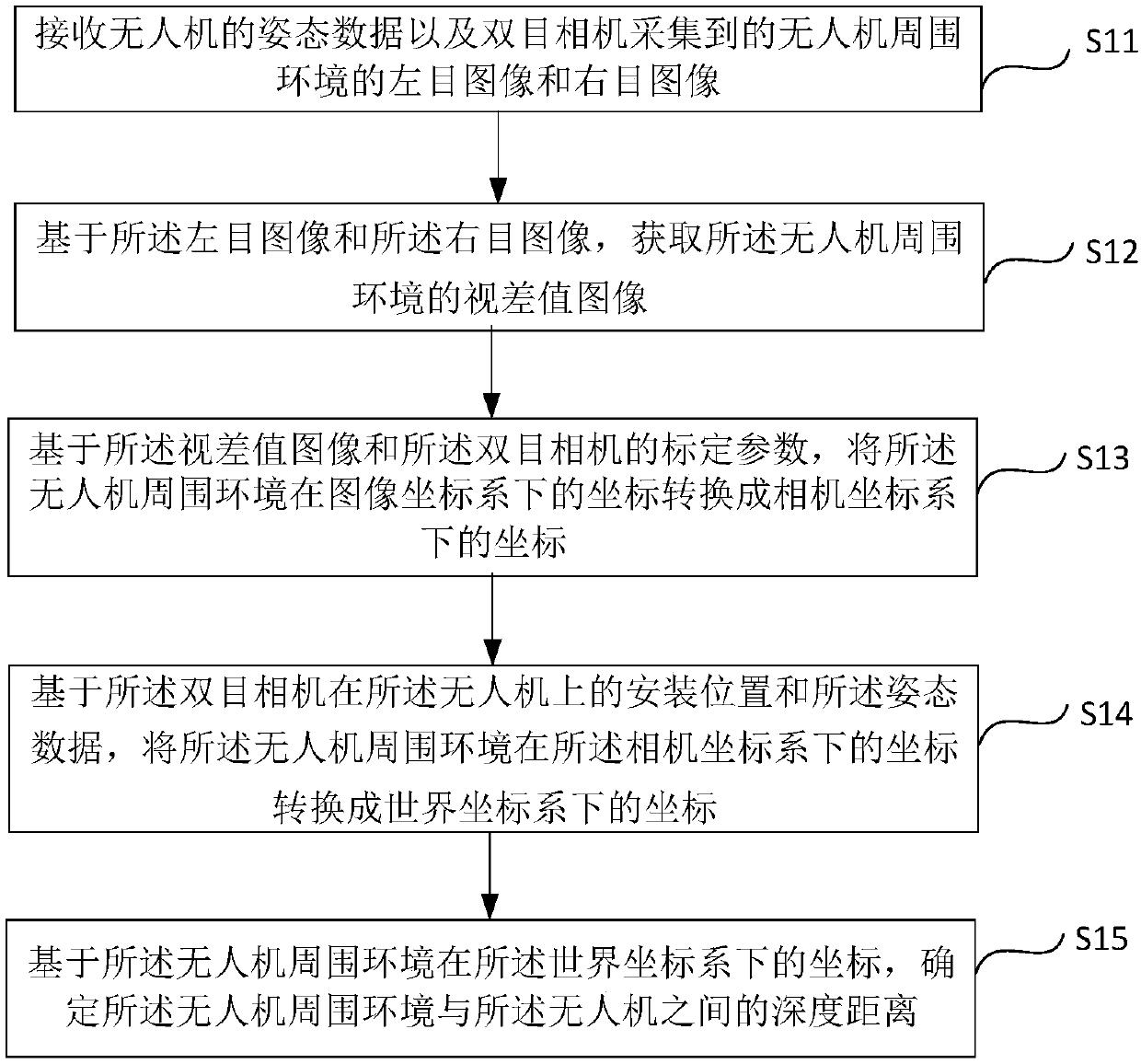
[0094] According to an embodiment of the present disclosure, a depth distance measurement method is provided, which can be applied to unmanned aerial vehicles, and can be used in the 3D environment information reconstruction algorithm of the UAV obstacle avoidance system based on embedded real-time binocular vision Realized to realize the UAV's obstacle avoidance and ranging functions. Such as figure 1 As shown, the method may include the following steps:

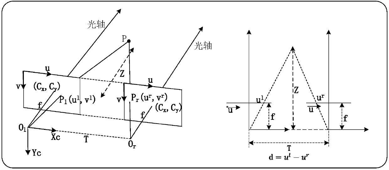
[0095] In step S11, the attitude data of the UAV and the left-eye image and right-eye image of the surrounding environment of the UAV collected by the binocular camera are received. Wherein, the attitud...


PUM


Abstract

The invention relates to a depth distance measurement method, device, computer readable storage medium and electronic equipment, which belong to the field of unmanned aerial vehicles, can accurately measure the depth distance between an unmanned aerial vehicle and a surrounding environment in real time and are beneficial to real-time obstacle avoidance of the unmanned aerial vehicle. The depth distance measurement method comprises: receiving attitude data of an unmanned aerial vehicle and left-eye images and right-eye images of a surrounding environment of the unmanned aerial vehicle acquiredby a binocular camera; acquiring a parallax value image of the surrounding environment of the unmanned aerial vehicle on the basis of the left-eye images and the right-eye images; based on the parallax value image and calibration parameters of the binocular camera, converting the coordinates of the surrounding environment of the unmanned aerial vehicle in an image coordinate system into coordinates in a camera coordinate system; based on a mounting position and attitude data of the binocular camera on the unmanned aerial vehicle, converting the coordinates of the surrounding environment of theunmanned aerial vehicle in the camera coordinate system into coordinates in a world coordinate system; and based on the coordinates of the surrounding environment of the unmanned aerial vehicle in the world coordinate system, determining the depth distance between the surrounding environment of the unmanned aerial vehicle and the unmanned aerial vehicle.

Description

technical field [0001] The present disclosure relates to the field of unmanned aerial vehicles, and in particular, relates to a depth distance measurement method, device, computer-readable storage medium, and electronic equipment. Background technique [0002] Usually, binocular cameras are installed on UAVs for ranging to achieve the purpose of UAV obstacle avoidance. When measuring the distance, the two cameras of the binocular camera will be used to collect the information of the surrounding environment of the drone to obtain the first video image information and the second video image information, and then select the first image and the second video image information from the first video image information respectively. The second image at the same moment is selected from the second video image information, and the depth distance between the drone and the surrounding environment is obtained according to the first image and the second image. However, the depth distance me...

Claims


Application Information

Patent Timeline
IPC IPC(8): G01C3/18
CPCG01C3/18
Inventor 刘秦徐保树李爽
Owner 沈阳上博智像科技有限公司
Why Eureka
Try Eureka