A Method for Estimating Elevation Angle of Low Altitude Targets in Complicated Terrain Conditions

A technology for low-altitude targets and complex terrain, applied to radio wave measurement systems, instruments, etc., can solve the problems of large measurement errors, reduce calculations, and large calculations, and achieve easy engineering implementation, improve angle estimation accuracy, and reduce calculations. volume effect

Active Publication Date: 2022-05-03
西安雷擎电子科技有限公司
View PDF5 Cites 0 Cited by
  • Summary
  • Abstract
  • Description
  • Claims
  • Application Information

AI Technical Summary

Problems solved by technology

[0004] In view of the deficiencies in the above-mentioned prior art, the purpose of the present invention is to propose a method for estimating the elevation angle of low-altitude targets under complex terrain conditions, which can reduce the amount of calculation and is easy to implement in engineering; It can improve the angle estimation performance of the radar under complex terrain conditions, enhance the stability and multi-scenario applicability of the angle estimation method, and realize the accurate detection and tracking of low-altitude targets under complex terrain conditions, mainly solving the large amount of calculation in the existing methods , Under complex terrain conditions, the measurement error is large and the application range is limited

Method used


Image

  • A Method for Estimating Elevation Angle of Low Altitude Targets in Complicated Terrain Conditions
  • A Method for Estimating Elevation Angle of Low Altitude Targets in Complicated Terrain Conditions
  • A Method for Estimating Elevation Angle of Low Altitude Targets in Complicated Terrain Conditions

Examples


Embodiment Construction

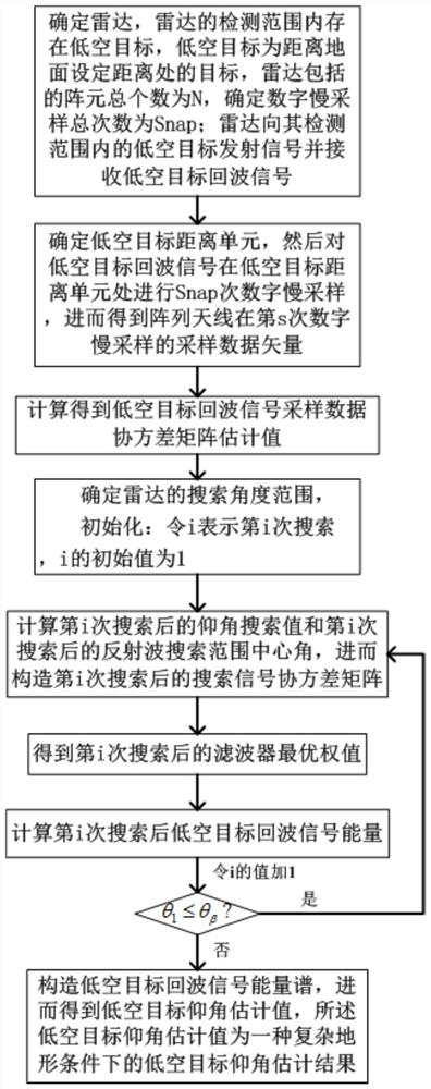
[0022] refer to figure 1 , is a flow chart of a method for estimating the elevation angle of a low-altitude target under a complex terrain condition of the present invention; wherein said method for estimating an elevation angle of a low-altitude target under a complex terrain condition comprises the following steps:

[0023] Step 1, the radar receives multiple sets of echo signals.

[0024] The radar adopts a uniformly spaced array line array. There are low-altitude targets within the detection range of the radar. The low-altitude targets are targets at a set distance from the ground. In this embodiment, the set distance is 100m; the total number of array elements included in the radar is N (N is a positive integer greater than or equal to 1), and the N array elements are sorted from the first array element to the Nth array element in turn, and the Nth array element is used as a reference array element, and the distance between the N array elements is equal; According to the...


PUM


Abstract

The invention discloses a method for estimating the elevation angle of a low-altitude target under complex terrain conditions. The main ideas are as follows: determine the radar, the low-altitude target exists in the detection range of the radar, the low-altitude target is a target at a set distance from the ground, and the array included in the radar The total number of elements is N, and the total number of digital slow sampling is determined as Snap. The radar sends signals to low-altitude targets within its detection range and receives low-altitude target echo signals; Perform Snap times digital slow sampling at the target range unit, and calculate the low-altitude target echo signal sampling data covariance matrix estimate value to determine the radar search angle range [θ α ,θ β ], θ α Indicates the minimum search angle of the radar, θ β Indicates the maximum value of the search angle of the radar; the energy spectrum E of the echo signal of the low-altitude target is constructed, and then the estimated value of the elevation angle of the low-altitude target is obtained, and the estimated value of the elevation angle of the low-altitude target is an estimation result of the elevation angle of the low-altitude target under complex terrain conditions.

Description

technical field [0001] The invention belongs to the technical field of radar parameter estimation, and in particular relates to a method for estimating the elevation angle of a low-altitude target under complex terrain conditions, which is applicable to the angle estimation of the target by radar in a multipath environment. Background technique [0002] When the radar measures the angle of the low-altitude target, the beam pointing angle of the radar is small, and it is easy to cause the beam to hit the ground, which makes the reflection of the ground and sea surface stronger, and at the same time, the received noise and clutter increase, and the multipath phenomenon of the target is serious. lead to inaccurate measurement results. Due to the influence of multipath effect, the direct echo and reflected echo of the strongly coherent target enter the same main lobe width of the receiving beam at the same time, and it is difficult to distinguish the two by general methods, whic...

Claims


Application Information

Patent Timeline
Patent Type & Authority Patents(China)
IPC IPC(8): G01S7/41
CPCG01S7/41
Inventor 曹运合李春阳彭志刚吴春林凤宏晓王从思
Owner 西安雷擎电子科技有限公司
Why Eureka
Try Eureka