
Mixed path planning method and system based on grid map

A grid map and mixed path technology, applied in the field of robot navigation, can solve the problems of high probability of mobile robot colliding with obstacles, slow implementation speed, no consideration of idle node traffic costs, etc., and achieve the effect of short algorithm processing time

Active Publication Date: 2018-09-18
CHANGSHA UNIVERSITY
View PDF6 Cites 50 Cited by
  • Summary
  • Abstract
  • Description
  • Claims
  • Application Information

AI Technical Summary

Problems solved by technology

[0004] In view of the above defects or improvement needs of the prior art, the present invention provides a hybrid path planning method based on a grid map, the purpose of which is to solve the problem that the A* search algorithm in the existing A*-DWA method does not consider the passage of idle nodes cost, resulting in a high probability of collision between the mobile robot and obstacles, and because multiple local target nodes will use the same parameter in the same orientation angle evaluation function, the planned path deviates from the original trajectory or the algorithm implementation speed is slow.

Method used


Image

  • Mixed path planning method and system based on grid map
  • Mixed path planning method and system based on grid map
  • Mixed path planning method and system based on grid map

Examples


Embodiment Construction

[0041] In order to make the objectives, technical solutions and advantages of the present invention clearer, the following further describes the present invention in detail with reference to the accompanying drawings and embodiments. It should be understood that the specific embodiments described herein are only used to explain the present invention, but not to limit the present invention. In addition, the technical features involved in the various embodiments of the present invention described below can be combined with each other as long as they do not conflict with each other.

[0042] The present invention proposes a hybrid path planning method based on a grid map, which uses the idea of ​​the local potential field method to perform local obstacle potential field calculations on the path nodes in the A* algorithm to obtain a global path with a higher security level for the mobile robot , And then detect the collision of local obstacles, modify the local path, and finally get ...


PUM


Abstract

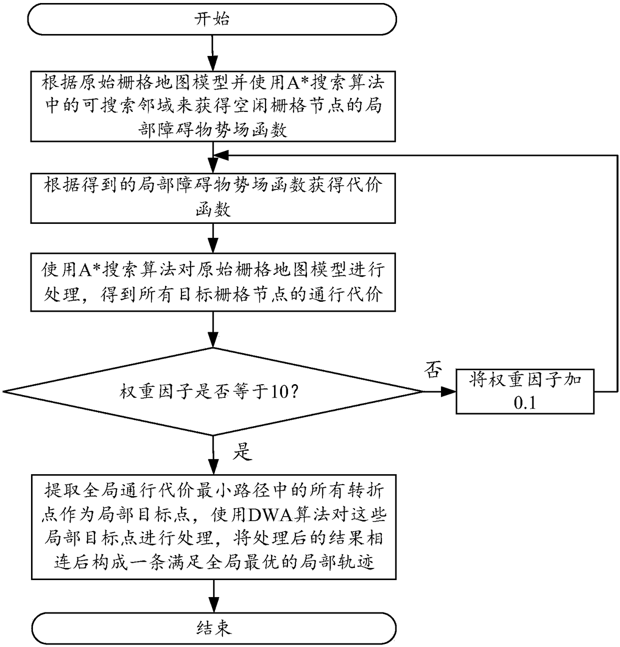
The invention discloses a mixed path planning method and system based on a grid map. The method comprises steps of according to an original grid map model, using a searchable neighborhood in the A*searching algorithm to acquire local obstacle potential field function of idle grid nodes; according to the obtained local obstacle potential field function, acquiring a cost function; using the A*searching algorithm to process the original grid map model so as to obtain passing cost of all target grid nodes; successively adding 0,1 to a weight factor mu and repeating above steps until the value of the mu is 10; finding a weight factor mu corresponding to the minimum value from the obtained passing cost; connecting all the corresponding target grid nodes to form a global passing cost smallest path; extracting all turning points in the global passing cost smallest path to serve as local target points; using the DWA algorithm to process the local target points; and connecting the processed results to form a local track meeting the global optimum.

Description

Technical field [0001] The invention belongs to the technical field of robot navigation, and more specifically, relates to a hybrid path planning method and system based on a grid map. Background technique [0002] Mobile robots have a wide range of needs and applications in industrial production, life services, disaster relief, environmental detection and other fields. Among them, navigation is one of the research hotspots in its technical field. The existing navigation path planning methods for mobile robots mainly combine the global path planning method and the local path planning method. The most representative one is the A* search algorithm and the dynamic window method (Dynamic window method) proposed by Hart in 1968. Window approach, DWA for short) is combined to form the so-called A*-DWA method. [0003] However, the above-mentioned A*-DWA method has some non-ignorable shortcomings in practical applications: First, because the A* search algorithm does not consider the traf...

Claims


Application Information

Patent Timeline
IPC IPC(8): G05D1/02
CPCG05D1/0214G05D1/0221G05D1/0223
Inventor 李方敏张凯威旷海兰彭小兵栾悉道杨志邦王雷
Owner CHANGSHA UNIVERSITY
Learn More