Free installation method of gnss/mems inertial integrated navigation system

A navigation system and inertial combination technology, applied in the field of free installation of GNSS/MEMS inertial integrated navigation system, can solve problems such as errors or deviations that cannot be corrected, poor carrier versatility, inconvenient use of equipment, etc., to achieve small calculation and fault tolerance High performance and real-time effects

Active Publication Date: 2022-04-29
北京沙谷科技有限责任公司
View PDF0 Cites 0 Cited by
  • Summary
  • Abstract
  • Description
  • Claims
  • Application Information

AI Technical Summary

Problems solved by technology

This method has the following disadvantages: first, the equipment is inconvenient to use, and it is not suitable for mass application of low-cost systems; second, the fault tolerance is poor, because the installation angle error is too dependent on the artificial offline measurement results, once an error or deviation occurs, it cannot Error correction; third, each device needs to calibrate the installation angle separately, which takes a long time to calibrate, and the cost of manpower and material resources is high; fourth, once the device is moved unintentionally, the installation angle needs to be re-measured; fifth, in order to accommodate the axial Consistent alignment, there are requirements for the reserved installation space of the carrier, and the versatility between different carriers is poor; sixth, some common carriers do not have the condition that the axis of the navigation device is consistent with the axis of the carrier, such as the round-trip of the railway transport carrier There will be an inconsistency of 180 degrees between the forward axis and the equipment axis, and there is no clear forward axis on the rotorcraft, etc.
To sum up, traditional equipment installation methods and technologies greatly limit the wide application of integrated navigation systems on various carriers

Method used


Image

  • Free installation method of gnss/mems inertial integrated navigation system
  • Free installation method of gnss/mems inertial integrated navigation system
  • Free installation method of gnss/mems inertial integrated navigation system

Examples


Embodiment Construction

[0053] The present invention will be described in detail below in conjunction with the accompanying drawings and specific embodiments.

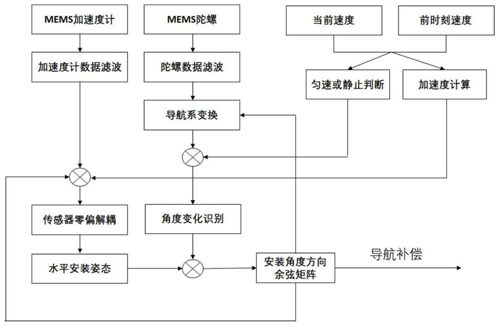
[0054] The invention provides a free installation method of a GNSS / MEMS inertial integrated navigation system, such as figure 1 As shown, it is a free installation technology of a GNSS / MEMS inertial sensor integrated navigation system assisted by GNSS velocity and gravity field projection information on a pan-carrier. The carrier involves but is not limited to automobiles, trains, bicycles, motorcycles, and small aircraft. , this technology can estimate the relative installation angle between the integrated navigation system and the carrier online, and accept the navigation system hardware equipment to be installed and placed at any angle on the carrier. Specifically, it is implemented according to the following steps: Assume that the initial value of the error angle is installed; in a static state, use this value to project the acceleration ...


PUM


Abstract

The invention discloses a free installation method of a GNSS / MEMS inertial integrated navigation system, which is characterized in that the initial value of the installation error angle is assumed; in a static state, the gravity acceleration is projected on the MEMS inertial sensor coordinate system by using the value, and its Compared with the output of the filtered MEMS accelerometer and gyroscope, the power-on zero bias of the MEMS accelerometer and gyroscope can be decoupled and estimated; the horizontal attitude of the decoupled navigation is estimated through filtering, and the assumed value of the horizontal installation angle is gradually corrected. Make the estimated value converge to the real horizontal installation angle; use the dynamic GNSS velocity information, acceleration measurement information and decoupled horizontal attitude to establish the heading of the filter decoupled navigation and gradually correct the azimuth installation angle; Identify the installation angle changes of the navigation system hardware equipment during use. This method can quickly complete the online dynamic calibration of the inertial sensor.

Description

technical field [0001] The invention belongs to the technical field of inertial navigation and satellite navigation, and in particular relates to a free installation method of a GNSS / MEMS inertial integrated navigation system. Background technique [0002] The Beidou satellite navigation system is a major national strategy of our country. It is a global satellite-based navigation system (GNSS) that keeps pace with the US GPS, Russia's GLONASS and Europe's GALILEO. With the gradual improvement of the Beidou Phase III network deployment, the Beidou system is being gradually popularized and applied to various military and civilian carriers in the sea, land and air. The salient feature of the satellite navigation system is that it directly provides absolute positioning coordinates, and the error does not accumulate over time, but there are deficiencies that radio signals are easily blocked and interfered. The inertial navigation system (Inertial Navigation System, INS) can inde...

Claims


Application Information

Patent Timeline
Patent Type & Authority Patents(China)
IPC IPC(8): G01S19/47G01C21/18G01C21/16G01C25/00G01C21/00
CPCG01C21/005G01C21/165G01C21/18G01C25/005G01S19/47
Inventor 杨勇刘华韩晓
Owner 北京沙谷科技有限责任公司
Why Eureka
Try Eureka