
Self-adaptive IDW interpolation method
An interpolation method and interpolation technology, applied in the fields of cartography and geographic information science, to achieve the effects of advanced methods, improved interpolation accuracy, and error avoidance
- Summary
- Abstract
- Description
- Claims
- Application Information
AI Technical Summary
Problems solved by technology
Method used
Image

Examples
Embodiment Construction
[0017] In order to describe the technical content, structural features, objectives and effects of the present invention in detail, the following will be described in detail in conjunction with specific embodiments.
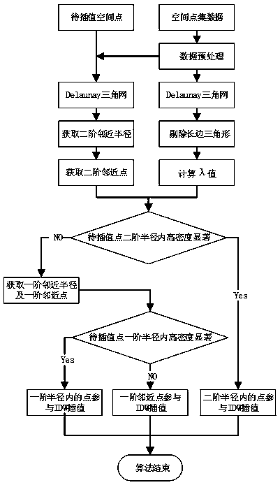
[0018] The implementation steps of the present invention can be summarized into two parts: data preprocessing and high-density saliency analysis within the second-order radius and first-order radius of the space point to be interpolated. Each implementation step is further described below.
[0019] The steps of data preprocessing include:
[0020] Step 1: Data cleaning. Due to the actual distribution of spatial data points, there may be cases of overlapping each other, that is, there are two or more points in one position, which will affect the subsequent generation of Delaunay triangulation. Therefore, keep any one of the spatial points located at the same position and with capping;
[0021] Step 2: Generate a Delaunay triangulation from the cleaned spatial po...
PUM
 Abstract
Description
Claims
Application Information