Data sharing system for driverless car, and path adjustment method

A technology for unmanned vehicles and unmanned vehicles, applied in the field of unmanned vehicle data sharing system and route adjustment, which can solve the problem of forced disclosure of information data, large amount of data processing, increased braking and lane change time of unmanned vehicles And other issues

Pending Publication Date: 2018-10-02
XUZHOU BLUE LAKE INFORMATION TECH CO LTD
View PDF8 Cites 19 Cited by
  • Summary
  • Abstract
  • Description
  • Claims
  • Application Information

AI Technical Summary

Problems solved by technology

[0002] At present, with the popularization of unmanned vehicles, the current driving of existing unmanned vehicles is to sense the surrounding environment through a large number of on-board sensors, and to control the movement of the vehicle based on the acquired information such as the road, the position of the vehicle on the road, and roadblocks. Road, steering path selection and speed change to ensure that the vehicle can travel reliably on the road. The sensor can only perceive the external environment of the vehicle. When there are a large number of unmanned vehicles on the road, the path selection of other unmanned vehicles cannot be pre-judged. After the unmanned car is detected by the sensor, it takes time to make judgments and control actions, which increases the time for a series of actions such as braking and lane changing of the unmanned car, and the processing time that can be reserved for high-speed driving is very short. Especially in the long road ahead, when there is a traffic accident, the unmanned car can only perceive it when it is close, and it cannot optimize the path in advance and replace it in time to avoid the problematic road section. The existing unmanned car data It will be stored on the data platform, and the data will be processed through the data platform. The data processing volume is huge, and the information update is slow, and timely interactive prediction and route optimization cannot be performed. , there will be driving problems for unmanned vehicles, and the large amount of data on the data platform is prone to the problem of forced disclosure of information and data
[0003] When unmanned vehicles are driving at high speed, they rely on data platforms to provide and analyze travel route data. Once they travel to remote places or places where the signal is blocked, they cannot receive real-time road conditions from the data platform in time, and unmanned vehicles are prone to misjudgment of routes. , the existing navigation maps rely on remote access to road condition information. For unmanned vehicles, the lag of the data is too strong, and the authenticity of the data is relatively poor

Method used


Image

  • Data sharing system for driverless car, and path adjustment method
  • Data sharing system for driverless car, and path adjustment method

Examples


Embodiment Construction

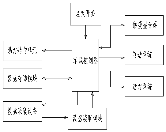
[0071] A kind of unmanned vehicle data sharing system of the present invention is realized like this:

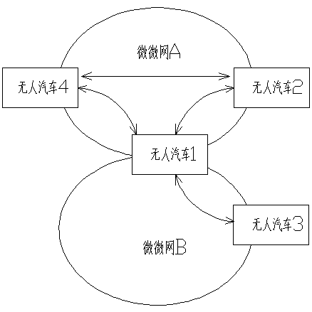
[0072] An unmanned vehicle data sharing system according to the present invention is characterized in that the unmanned vehicle obtains the required driving road condition data through the piconet sharing the driving data, and then performs data fitting, adjusts and changes the route and optimizes the driving route.

[0073] The piconet includes a piconet established between multiple unmanned vehicles, a piconet established by unmanned vehicles and traffic lights, and a piconet established by unmanned vehicles and other smart devices;

[0074] The piconet is established between the peer-to-peer devices carried on the unmanned vehicle, or between the peer-to-peer devices carried by the unmanned vehicle and the collection equipment on the traffic lights, or it can be established by the unmanned vehicle and other smart devices. Establish,

[0075] The peer-to-peer device inclu...


PUM


Abstract

The invention relates to a data sharing system for a driverless car, and discloses the building of a piconet for sharing the path driving data of the driverless car, a data sharing system for replanning of an optimal path and a path adjustment method. Through cooperating with the Internet big data platform, the system and method can improve the driving efficiency of the driverless car. The systemis characterized in that the driverless car obtains the required driving condition data through the piconet for sharing the driving data, performs the data fitting, and adjusts and changes the path for optimizing the path; the piconets comprise the piconet built among a plurality of driverless cars, the piconet between the driverless cars and the traffic lights, and the piconet between the driverless cars and other smart equipment; the piconet are built between the equivalent devices on the driverless cars, or build between the equivalent devices on the driverless cars and the traffic lights,and also can be built between the driverless cars and other smart equipment.

Description

technical field [0001] The invention discloses a data sharing system and a route adjustment method for unmanned vehicles, relating to a system and a route adjustment method for data sharing of unmanned vehicles within an area in an unmanned driving environment, and belongs to the field of vehicle engineering. Background technique [0002] At present, with the popularization of unmanned vehicles, the current driving of existing unmanned vehicles is to sense the surrounding environment through a large number of on-board sensors, and to control the movement of the vehicle based on the acquired information such as the road, the position of the vehicle on the road, and roadblocks. Road, steering path selection and speed change to ensure that the vehicle can travel reliably on the road. The sensor can only perceive the external environment of the vehicle. When there are a large number of unmanned vehicles on the road, the path selection of other unmanned vehicles cannot be pre-judg...

Claims


Application Information

Patent Timeline
Patent Type & Authority Applications(China)
IPC IPC(8): G08G1/0967G08G1/0968H04L29/08
CPCG08G1/096725G08G1/096791G08G1/096844G08G1/096866H04L67/12
Inventor 王国庆
Owner XUZHOU BLUE LAKE INFORMATION TECH CO LTD
Why Eureka
Try Eureka