Auxiliary decision-making system and planning method for regional agricultural planning based on gis

An auxiliary decision-making and regional planning technology, applied in data processing applications, forecasting, instruments, etc., can solve the problems of planners' backward technical methods, many uncertain factors, and insufficient dynamic analysis, etc., to achieve wide practicability, popularization, and rich Methods and means to improve scientific and intelligent effects

Active Publication Date: 2022-02-01
广东省农业科学院农业经济与信息研究所
View PDF3 Cites 0 Cited by
  • Summary
  • Abstract
  • Description
  • Claims
  • Application Information

AI Technical Summary

Problems solved by technology

Because regional agricultural planning is a complex systematic project, it has the characteristics of large amount of data, many uncertain factors, wide range of fields involved, and rapid changes in the status quo. In addition, the professional limitations of planners and backward technical methods have led to the long-term existence of data in current agricultural planning. Scattered and messy, repeated data statistics, less spatial quantitative analysis, difficulty in accurate landing, insufficient dynamic analysis, etc.

Method used


Image

  • Auxiliary decision-making system and planning method for regional agricultural planning based on gis
  • Auxiliary decision-making system and planning method for regional agricultural planning based on gis

Examples


Embodiment

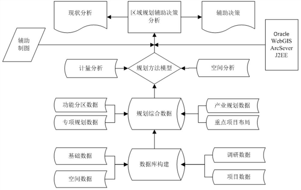
[0052] data management

[0053] (1) Statistical yearbook data. Realize the import and view of statistical yearbook data. With the town as the unit, the economic and industrial data over the years can be established, and the administrative division can be visualized with the town as the unit. The yearbook data is maintained and managed by another database and obtained through the interface. Support WPS template data import. The imported statistical yearbook data is summarized and displayed by category, and tables and histograms are supported.

[0054] (2) Spatial data management. For scanned images or raster images, perform registration, spatial element plotting, and attribute data entry. For raster data, such as remote sensing images, coordinates are registered through the Tiandi map, and then human-computer interaction is used to plot point, line, and area elements, and input the attribute data of the elements. For vector data, such as CAD files, it can be imported with...


PUM


Abstract

The present invention is an auxiliary decision-making system for regional agricultural planning based on GIS. The system includes: a data management module for managing input data; a regional planning module for analyzing data in different regions and assisting in making planning decisions . Aiming at the problems in regional agricultural planning such as scattered and disordered data, less spatial quantitative analysis, difficulty in accurate landing, insufficient dynamic analysis, etc., the present invention introduces powerful data management and spatial analysis functions of GIS, and develops A regional agricultural planning auxiliary decision-making system integrating data management, current situation analysis, planning positioning, functional zoning, industrial planning, key projects, and investment estimation has been established, and the standardized storage of agricultural planning data, quantitative analysis of spatial data and planning auxiliary mapping have been realized. It can effectively improve the standardization, scientificity and accuracy of planning.

Description

technical field [0001] The invention belongs to a computing system for regional planning, in particular to a GIS-based auxiliary decision-making system for regional agricultural planning and a planning method. Background technique [0002] Regional agricultural planning is based on the needs of national economic development in a certain period of time, and on the basis of fully considering the existing agricultural development status, natural resources, social and economic conditions, ecological environment, etc. The overall deployment of efficient resource utilization and rational space layout is a systematic project of goals and constraints, organization and implementation. Scientific and reasonable agricultural planning plays an important strategic role in the development of regional modern agriculture. [0003] As an important means for the government to control the market, regional agricultural planning has been increasingly valued by government departments at all leve...

Claims


Application Information

Patent Timeline
Patent Type & Authority Patents(China)
IPC IPC(8): G06Q10/04G06Q50/02
CPCG06Q10/04G06Q50/02
Inventor 周灿芳刘序余华荣雷百战
Owner 广东省农业科学院农业经济与信息研究所
Why Eureka
Try Eureka