
Remote sensing monitoring method of waterlogging of winter wheat, based on fusion of satellite-ground multi-source rainfall data

A technology of data fusion and remote sensing monitoring, applied in data processing applications, resources, instruments, etc., can solve problems such as spatial monitoring errors of winter wheat wet damage

Active Publication Date: 2018-11-06
ZHEJIANG UNIV
View PDF5 Cites 14 Cited by
  • Summary
  • Abstract
  • Description
  • Claims
  • Application Information

AI Technical Summary

Problems solved by technology

[0005] The purpose of the present invention is to solve the difficulty of using the surface rain gauge alone to observe the precipitation to monitor the space of winter wheat wet damage, and to use satellite inversion precipitation products alone to have a large error in the spatial monitoring of winter wheat wet damage. Geographically weighted regression Klicking method fuses precipitation data from surface rain gauges and satellite retrieval products to obtain a high-quality, high-spatial-resolution spatial precipitation data set, and uses the data for spatial monitoring of wet-soaked winter wheat

Method used


Image

  • Remote sensing monitoring method of waterlogging of winter wheat, based on fusion of satellite-ground multi-source rainfall data
  • Remote sensing monitoring method of waterlogging of winter wheat, based on fusion of satellite-ground multi-source rainfall data
  • Remote sensing monitoring method of waterlogging of winter wheat, based on fusion of satellite-ground multi-source rainfall data

Examples


Embodiment Construction

[0033] In the following, Jiangsu, Anhui and Hubei provinces of my country are taken as example study areas, and typical waterlogging years (2001, 2002, 2003, 2010, 2013 and 2014) from 2001 to 2014 recorded in literature and field surveys are taken as examples, combined with specific drawings The present invention is described in further detail.

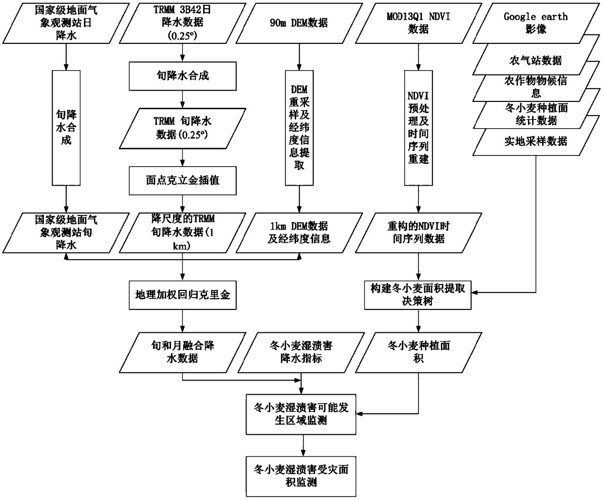
[0034] Such as figure 1 As shown, it is a flow chart of the remote sensing monitoring method for wet waterlogging damage of winter wheat based on the fusion of satellite-earth multi-source precipitation data according to the present invention. It includes the following steps:

[0035] Step 1. Obtain and organize the precipitation data set observed by surface rain gauges (daily precipitation at national surface meteorological observation stations), satellite inversion precipitation data set (TRMM 3B42 daily precipitation data (0.25°)), NDVI data set (MOD13Q1NDVI data), DEM data (90m), Google earth images, winter wheat growth period da...


PUM


Abstract

The invention discloses a remote sensing monitoring method of waterlogging of winter wheat, based on fusion of satellite-ground multi-source rainfall data. The remote sensing monitoring method includes the steps: collecting and arranging a ground pluviometer to observe a rainfall data set, a satellite inversion rainfall data set, an NDVI data set, DEM data, phenology information of crops, statistical data of cultivated area of winter wheat, and field sampling data of winter wheat planting region, and preprocessing and filtering the NDVI data; extracting the spatial information of the cultivated area of winter wheat by means of the NDVI time sequence data after processing; constructing a quantitative model of rainfall information fusion by means of a geographic weighted regression Kriging method, and obtaining a rainfall data set; and by means of the rainfall data set and the extracted cultivated area of winter wheat, combining with the waterlogging disaster index, monitoring the waterlogging damage area of winter wheat. The remote sensing monitoring method of waterlogging of winter wheat, based on fusion of satellite-ground multi-source rainfall data is an effective method of monitoring the waterlogging space of crops in a large range by means of the data, and has stable technical practicability.

Description

technical field [0001] The invention belongs to the field of agricultural meteorological disaster monitoring, and in particular relates to a remote sensing monitoring method for winter wheat wet soil damage based on fusion of satellite-earth multi-source precipitation data. Background technique [0002] Under the background of climate change, the increase of extreme weather and climate events has made agricultural meteorological disasters present a trend of high frequency, high intensity, and increasingly serious danger, and the impact on agricultural production is increasing. Wet waterlogging is one of the common agricultural meteorological disasters in the world. It occurs in the United States, Australia, Russia, central and eastern Africa, China, Pakistan, India, Nepal, Bangladesh and other countries, and it will cause damage to crops in different growth stages. different degrees of harm. It is estimated that about 10% of the world's land is severely affected by soil wat...

Claims


Application Information

Patent Timeline
IPC IPC(8): G06Q10/06G06Q50/02
CPCG06Q10/06393G06Q50/02
Inventor 陈圆圆黄敬峰
Owner ZHEJIANG UNIV
Learn More